array:1 [
"RF Query: /Property?$select=ALL&$orderby=LivingArea DESC&$top=12&$skip=88836&$filter=(StandardStatus in ('Active','Pending','Active Under Contract','Coming Soon') and PropertyType in ('Residential','Land'))/Property?$select=ALL&$orderby=LivingArea DESC&$top=12&$skip=88836&$filter=(StandardStatus in ('Active','Pending','Active Under Contract','Coming Soon') and PropertyType in ('Residential','Land'))&$expand=Media/Property?$select=ALL&$orderby=LivingArea DESC&$top=12&$skip=88836&$filter=(StandardStatus in ('Active','Pending','Active Under Contract','Coming Soon') and PropertyType in ('Residential','Land'))/Property?$select=ALL&$orderby=LivingArea DESC&$top=12&$skip=88836&$filter=(StandardStatus in ('Active','Pending','Active Under Contract','Coming Soon') and PropertyType in ('Residential','Land'))&$expand=Media&$count=true" => array:2 [
"RF Response" => Realtyna\MlsOnTheFly\Components\CloudPost\SubComponents\RFClient\SDK\RF\RFResponse {#4682
+items: array:12 [
0 => Realtyna\MlsOnTheFly\Components\CloudPost\SubComponents\RFClient\SDK\RF\Entities\RFProperty {#4691
+post_id: "119950"
+post_author: 1
+"ListingKey": "1119717921"
+"ListingId": "21007336"
+"PropertyType": "Land"
+"PropertySubType": "Unimproved Land"
+"StandardStatus": "Active"
+"ModificationTimestamp": "2025-07-22T01:11:06Z"
+"RFModificationTimestamp": "2025-07-22T04:53:35Z"
+"ListPrice": 15000.0
+"BathroomsTotalInteger": 0
+"BathroomsHalf": 0
+"BedroomsTotal": 0
+"LotSizeArea": 0.331
+"LivingArea": 0
+"BuildingAreaTotal": 0
+"City": "Rice"
+"PostalCode": "75155"
+"UnparsedAddress": "Tbd Nw Private Road 0190m, Rice, Texas 75155"
+"Coordinates": array:2 [
0 => -96.523836
1 => 32.254626
]
+"Latitude": 32.254626
+"Longitude": -96.523836
+"YearBuilt": 0
+"InternetAddressDisplayYN": true
+"FeedTypes": "IDX"
+"ListAgentFullName": "Jeffery Smith"
+"ListOfficeName": "Century 21 Mike Bowman, Inc."
+"ListAgentMlsId": "0467722"
+"ListOfficeMlsId": "BWMN01EU"
+"OriginatingSystemName": "NTR"
+"PublicRemarks": "Small residential lot priced to move quick!"
+"AttributionContact": "817-354-7653"
+"Cooling": "None"
+"Country": "US"
+"CountyOrParish": "Navarro"
+"CreationDate": "2025-07-22T04:53:25.032164+00:00"
+"DevelopmentStatus": "Site Plan Approved"
+"Directions": "From Alma going South on IH 45, stay on the Southbound service road Lindle Road, Go right then left onto Old Alma Rd. Go right on County Line Rd, cross RR tracks, follow to NE CR 190, left onto NW Private Road 190M. Go down to sign on property on the left."
+"DocumentsAvailable": "Aerial"
+"ElementarySchool": "Rice"
+"ElementarySchoolDistrict": "Rice ISD"
+"Heating": "None"
+"HighSchool": "Rice"
+"HighSchoolDistrict": "Rice ISD"
+"RFTransactionType": "For Sale"
+"InternetAutomatedValuationDisplayYN": true
+"InternetConsumerCommentYN": true
+"InternetEntireListingDisplayYN": true
+"ListAgentAOR": "Metrotex Association of Realtors Inc"
+"ListAgentDirectPhone": "903-654-0411"
+"ListAgentEmail": "jeff.smith@c21bowman.com"
+"ListAgentFirstName": "Jeffery"
+"ListAgentKey": "20463196"
+"ListAgentKeyNumeric": "20463196"
+"ListAgentLastName": "Smith"
+"ListAgentMiddleName": "G"
+"ListOfficeKey": "4511715"
+"ListOfficeKeyNumeric": "4511715"
+"ListOfficePhone": "817-354-7653"
+"ListingAgreement": "Exclusive Right To Sell"
+"ListingContractDate": "2025-07-21"
+"ListingKeyNumeric": 1119717921
+"ListingTerms": "Cash, Conventional"
+"LockBoxType": "None"
+"LotFeatures": "Other"
+"LotSizeAcres": 0.331
+"LotSizeSquareFeet": 14418.36
+"MajorChangeTimestamp": "2025-07-21T16:34:24Z"
+"MiddleOrJuniorSchool": "Rice"
+"MlsStatus": "Active"
+"OriginalListPrice": 15000.0
+"OriginatingSystemKey": "459573004"
+"OwnerName": "Angela L and Roosevelt McElroy"
+"ParcelNumber": "49878"
+"PhotosChangeTimestamp": "2025-07-21T21:35:41Z"
+"PhotosCount": 3
+"Possession": "Close Of Escrow"
+"RoadFrontageType": "Private Road"
+"RoadSurfaceType": "Gravel"
+"ShowingRequirements": "Go Direct"
+"SpecialListingConditions": "Standard"
+"StateOrProvince": "TX"
+"StatusChangeTimestamp": "2025-07-21T16:34:24Z"
+"StreetDirPrefix": "NW"
+"StreetName": "Private Road 0190m"
+"StreetNumber": "TBD"
+"SubdivisionName": "Valley View Ranch Estates"
+"SyndicateTo": "Homes.com,IDX Sites,Realtor.com,RPR,Syndication Allowed"
+"TaxAnnualAmount": "56.0"
+"TaxLegalDescription": "V0050 VALLEY VIEW RANCH ESTATES LOT 23A .331"
+"TaxLot": "23A"
+"VirtualTourURLUnbranded": "https://www.propertypanorama.com/instaview/ntreis/21007336"
+"ZoningDescription": "Residential"
+"Restrictions": "No Restrictions"
+"HumanModifiedYN": false
+"GarageDimensions": ",,"
+"TitleCompanyPhone": "999-999-9999"
+"TitleCompanyAddress": "TBD"
+"TitleCompanyPreferred": "TBD"
+"OriginatingSystemSubName": "NTR_NTREIS"
+"@odata.id": "https://api.realtyfeed.com/reso/odata/Property('1119717921')"
+"provider_name": "NTREIS"
+"short_address": "Rice, Texas 75155, US"
+"RecordSignature": -2142689831
+"UniversalParcelId": "urn:reso:upi:2.0:US:48349:49878"
+"CountrySubdivision": "48349"
+"Media": array:3 [
0 => array:57 [
"Order" => 1
"ImageOf" => "Other"
"ListAOR" => "Metrotex Association of Realtors Inc"
"MediaKey" => "2004111711052"
"MediaURL" => "https://cdn.realtyfeed.com/cdn/119/1119717921/08e8a5f01131cb809a0023081aa5d496.webp"
"ClassName" => null
"MediaHTML" => null
"MediaSize" => 339856
"MediaType" => "webp"
"Thumbnail" => "https://cdn.realtyfeed.com/cdn/119/1119717921/thumbnail-08e8a5f01131cb809a0023081aa5d496.webp"
"ImageWidth" => null
"Permission" => null
"ImageHeight" => null
"MediaStatus" => null
"SyndicateTo" => "Homes.com,IDX Sites,Realtor.com,RPR,Syndication Allowed"
"ListAgentKey" => "20463196"
"PropertyType" => "Land"
"ResourceName" => "Property"
"ListOfficeKey" => "4511715"
"MediaCategory" => "Photo"
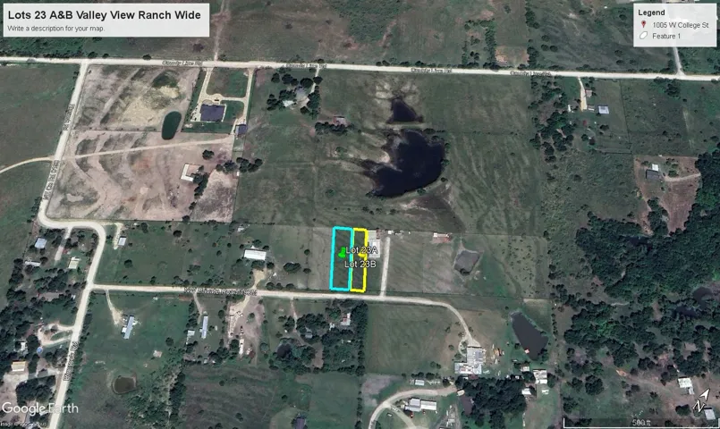
"MediaObjectID" => "Lots 23 A&B Valley View Ranch Close.jpg"
"OffMarketDate" => null
"X_MediaStream" => null
"SourceSystemID" => "TRESTLE"
"StandardStatus" => "Active"
"HumanModifiedYN" => false
"ListOfficeMlsId" => null
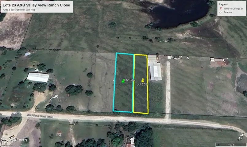
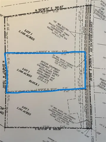
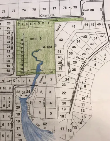
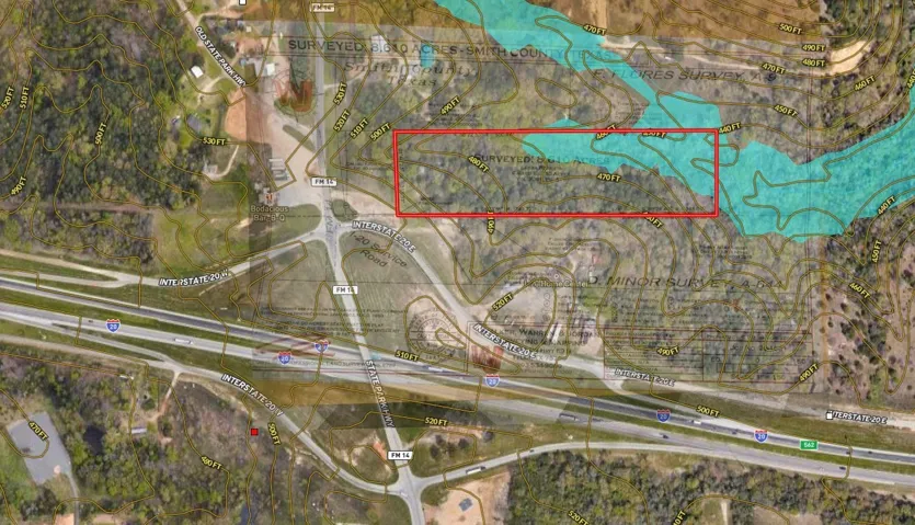
"LongDescription" => "Map / location featuring property boundaries highlighted"
"MediaAlteration" => null
"MediaKeyNumeric" => 2004111711052
"PropertySubType" => "Unimproved Land"
"RecordSignature" => 1388950146
"PreferredPhotoYN" => null
"ResourceRecordID" => "21007336"
"ShortDescription" => null
"SourceSystemName" => null
"ChangedByMemberID" => null
"ListingPermission" => null
"ResourceRecordKey" => "1119717921"
"ChangedByMemberKey" => null
"MediaClassification" => "PHOTO"
"OriginatingSystemID" => null
"ImageSizeDescription" => null
"SourceSystemMediaKey" => null
"ModificationTimestamp" => "2025-07-21T21:34:49.453-00:00"
"OriginatingSystemName" => "NTR"
"MediaStatusDescription" => null
"OriginatingSystemSubName" => "NTR_NTREIS"
"ResourceRecordKeyNumeric" => 1119717921
"ChangedByMemberKeyNumeric" => null
"OriginatingSystemMediaKey" => "459579676"
"PropertySubTypeAdditional" => "Unimproved Land"
"MediaModificationTimestamp" => "2025-07-21T21:34:49.453-00:00"
"SourceSystemResourceRecordKey" => null
"InternetEntireListingDisplayYN" => true
"OriginatingSystemResourceRecordId" => null
"OriginatingSystemResourceRecordKey" => "459573004"
]
1 => array:57 [
"Order" => 2
"ImageOf" => "Other"
"ListAOR" => "Metrotex Association of Realtors Inc"
"MediaKey" => "2004111711054"
"MediaURL" => "https://cdn.realtyfeed.com/cdn/119/1119717921/4ec38d713bf013abf19a340e2c6494c5.webp"
"ClassName" => null
"MediaHTML" => null
"MediaSize" => 490728
"MediaType" => "webp"
"Thumbnail" => "https://cdn.realtyfeed.com/cdn/119/1119717921/thumbnail-4ec38d713bf013abf19a340e2c6494c5.webp"
"ImageWidth" => null
"Permission" => null
"ImageHeight" => null
"MediaStatus" => null
"SyndicateTo" => "Homes.com,IDX Sites,Realtor.com,RPR,Syndication Allowed"
"ListAgentKey" => "20463196"
"PropertyType" => "Land"
"ResourceName" => "Property"
"ListOfficeKey" => "4511715"
"MediaCategory" => "Photo"
"MediaObjectID" => "Lots 23 A&B Valley View Ranch Wide.jpg"
"OffMarketDate" => null
"X_MediaStream" => null
"SourceSystemID" => "TRESTLE"
"StandardStatus" => "Active"
"HumanModifiedYN" => false
"ListOfficeMlsId" => null
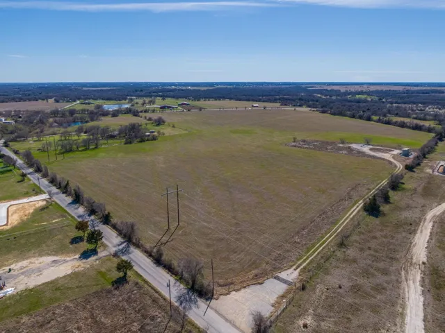
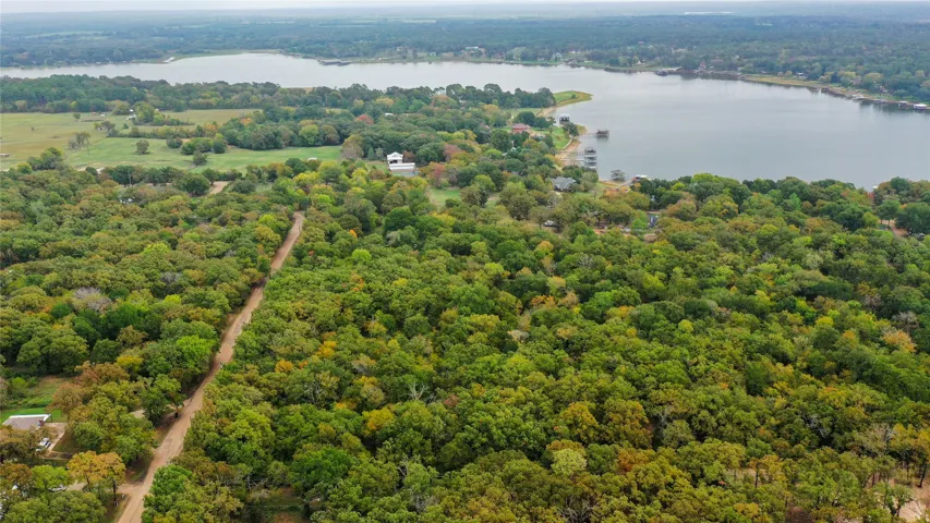
"LongDescription" => "Aerial overview of property's location with property boundaries highlighted"
"MediaAlteration" => null
"MediaKeyNumeric" => 2004111711054
"PropertySubType" => "Unimproved Land"
"RecordSignature" => 1388950146
"PreferredPhotoYN" => null
"ResourceRecordID" => "21007336"
"ShortDescription" => null
"SourceSystemName" => null
"ChangedByMemberID" => null
"ListingPermission" => null
"ResourceRecordKey" => "1119717921"
"ChangedByMemberKey" => null
"MediaClassification" => "PHOTO"
"OriginatingSystemID" => null
"ImageSizeDescription" => null
"SourceSystemMediaKey" => null
"ModificationTimestamp" => "2025-07-21T21:34:49.453-00:00"
"OriginatingSystemName" => "NTR"
"MediaStatusDescription" => null
"OriginatingSystemSubName" => "NTR_NTREIS"
"ResourceRecordKeyNumeric" => 1119717921
"ChangedByMemberKeyNumeric" => null
"OriginatingSystemMediaKey" => "459579678"
"PropertySubTypeAdditional" => "Unimproved Land"
"MediaModificationTimestamp" => "2025-07-21T21:34:49.453-00:00"
"SourceSystemResourceRecordKey" => null
"InternetEntireListingDisplayYN" => true
"OriginatingSystemResourceRecordId" => null
"OriginatingSystemResourceRecordKey" => "459573004"
]
2 => array:57 [
"Order" => 3
"ImageOf" => "Other"
"ListAOR" => "Metrotex Association of Realtors Inc"
"MediaKey" => "2004111711055"
"MediaURL" => "https://cdn.realtyfeed.com/cdn/119/1119717921/16709809ef5071c3d6f9ad8ed167d515.webp"
"ClassName" => null
"MediaHTML" => null
"MediaSize" => 543733
"MediaType" => "webp"
"Thumbnail" => "https://cdn.realtyfeed.com/cdn/119/1119717921/thumbnail-16709809ef5071c3d6f9ad8ed167d515.webp"
"ImageWidth" => null
"Permission" => null
"ImageHeight" => null
"MediaStatus" => null
"SyndicateTo" => "Homes.com,IDX Sites,Realtor.com,RPR,Syndication Allowed"
"ListAgentKey" => "20463196"
"PropertyType" => "Land"
"ResourceName" => "Property"
"ListOfficeKey" => "4511715"
"MediaCategory" => "Photo"
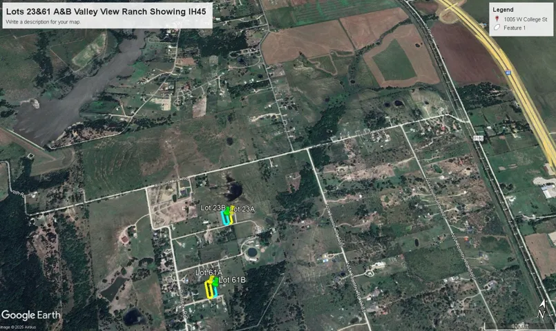
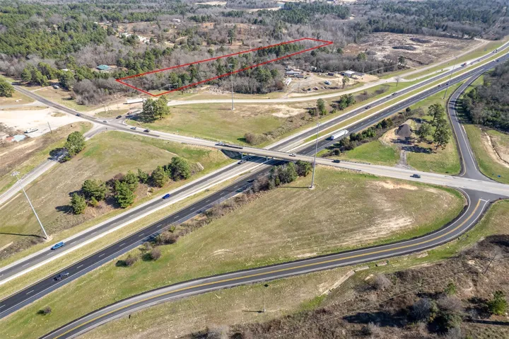
"MediaObjectID" => "Lots 23&61 A&B Valley View Ranch Showing IH45.jpg"
"OffMarketDate" => null
"X_MediaStream" => null
"SourceSystemID" => "TRESTLE"
"StandardStatus" => "Active"
"HumanModifiedYN" => false
"ListOfficeMlsId" => null
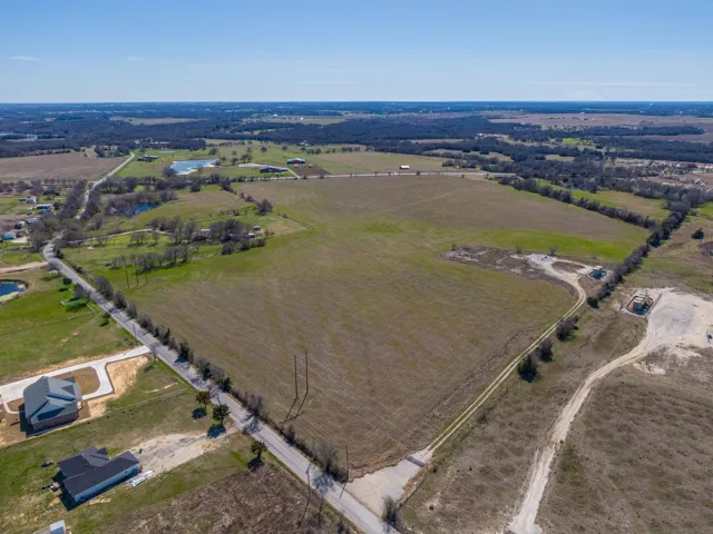
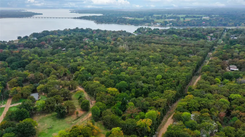
"LongDescription" => "Aerial map of property and surrounding area"
"MediaAlteration" => null
"MediaKeyNumeric" => 2004111711055
"PropertySubType" => "Unimproved Land"
"RecordSignature" => 1388950146
"PreferredPhotoYN" => null
"ResourceRecordID" => "21007336"
"ShortDescription" => null
"SourceSystemName" => null
"ChangedByMemberID" => null
"ListingPermission" => null
"ResourceRecordKey" => "1119717921"
"ChangedByMemberKey" => null
"MediaClassification" => "PHOTO"
"OriginatingSystemID" => null
"ImageSizeDescription" => null
"SourceSystemMediaKey" => null
"ModificationTimestamp" => "2025-07-21T21:34:49.453-00:00"
"OriginatingSystemName" => "NTR"
"MediaStatusDescription" => null
"OriginatingSystemSubName" => "NTR_NTREIS"
"ResourceRecordKeyNumeric" => 1119717921
"ChangedByMemberKeyNumeric" => null
"OriginatingSystemMediaKey" => "459579679"
"PropertySubTypeAdditional" => "Unimproved Land"
"MediaModificationTimestamp" => "2025-07-21T21:34:49.453-00:00"
"SourceSystemResourceRecordKey" => null
"InternetEntireListingDisplayYN" => true
"OriginatingSystemResourceRecordId" => null
"OriginatingSystemResourceRecordKey" => "459573004"
]
]
+"ID": "119950"
}
1 => Realtyna\MlsOnTheFly\Components\CloudPost\SubComponents\RFClient\SDK\RF\Entities\RFProperty {#4689
+post_id: "27872"
+post_author: 1
+"ListingKey": "1086923499"
+"ListingId": "20729279"
+"PropertyType": "Land"
+"PropertySubType": "Unimproved Land"
+"StandardStatus": "Active"
+"ModificationTimestamp": "2025-07-22T02:31:15Z"
+"RFModificationTimestamp": "2025-07-22T04:07:08Z"
+"ListPrice": 10712800.0
+"BathroomsTotalInteger": 0
+"BathroomsHalf": 0
+"BedroomsTotal": 0
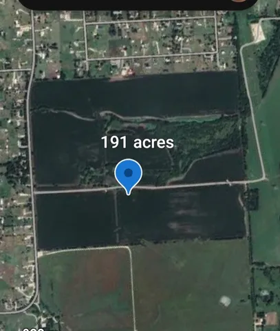
+"LotSizeArea": 191.3
+"LivingArea": 0
+"BuildingAreaTotal": 0
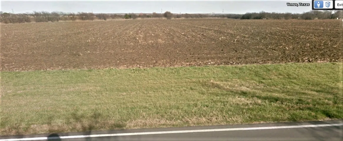
+"City": "Venus"
+"PostalCode": "76084"
+"UnparsedAddress": "3632 Cr-619 Highway, Venus, Texas 76084"
+"Coordinates": array:2 [
0 => -97.107142
1 => 32.479762
]
+"Latitude": 32.479762
+"Longitude": -97.107142
+"YearBuilt": 0
+"InternetAddressDisplayYN": true
+"FeedTypes": "IDX"
+"ListAgentFullName": "Rick Vehon"
+"ListOfficeName": "Vehon Realtor Group"
+"ListAgentMlsId": "0486447"
+"ListOfficeMlsId": "VHNR010AR"
+"OriginatingSystemName": "NTR"
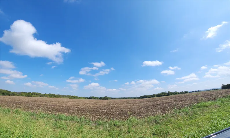
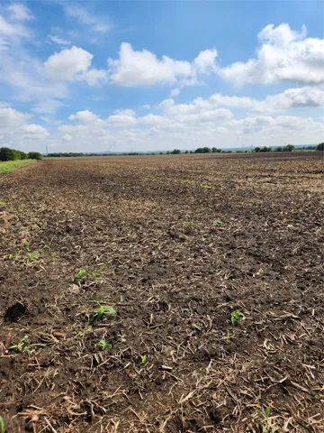
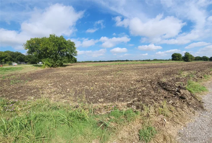
+"PublicRemarks": "This is the last of the undeveloped mostly cleared and flat acreage between Mansfield and Venus Tx. It's in unincorporated area and not zoned. This location is where it's happening with Southeast connector from 820 south on Hwy 287 to 67, Lone Star redevelopment and TXDOT realigning FM 157 from Mansfield. Road down middle of property that has over 2,500 feet of frontage. Land is not in flood zone, no high wires, no gas collection machinery. Easy access to 6 major highways, approximately 20 miles to Dallas, Fort Worth and DFW airport. Surface rights convey to new Buyer. Sellers retain subsurface mineral rights. There's no contract in place for a farmer who plants corn and harvests it. He's allowed to harvest crops if in ground. All offers must include a Proof of Funds or a Letter of Approval from valid financial institution. Per Fielder Farm Partners I'm only allowed too submit offers that have proof that Buyer can pay the price they offer."
+"AttributionContact": "214-801-4586"
+"CLIP": 2747708744
+"Country": "US"
+"CountyOrParish": "Johnson"
+"CreationDate": "2024-09-18T15:17:18.731257+00:00"
+"CumulativeDaysOnMarket": 209
+"CurrentUse": "Agricultural"
+"Directions": "From Hwy 287 take Lone Star Rd business 287 exit. Turn west onto FM 157. Land on left approximately 4 miles behind row of mailboxes. From Hwy 67 in Venus, N on FM 157 3 miles around second curve. Land will be on your right after first big curve. Gravel road down middle of land. Entry is from 157."
+"DocumentsAvailable": "Other,Aerial,Environmental Study,Survey"
+"ElementarySchool": "Venus"
+"ElementarySchoolDistrict": "Venus ISD"
+"Exclusions": "All Subsurface Minerals"
+"ExteriorFeatures": "Other"
+"Fencing": "Partial"
+"HighSchool": "Venus"
+"HighSchoolDistrict": "Venus ISD"
+"HorseAmenities": "Other"
+"HumanModifiedYN": true
+"RFTransactionType": "For Sale"
+"InternetConsumerCommentYN": true
+"InternetEntireListingDisplayYN": true
+"ListAgentAOR": "Arlington Board Of Realtors"
+"ListAgentDirectPhone": "214-801-4586"
+"ListAgentEmail": "rickve1215@yahoo.com"
+"ListAgentFirstName": "Rick"
+"ListAgentKey": "20465799"
+"ListAgentKeyNumeric": "20465799"
+"ListAgentLastName": "Vehon"
+"ListAgentMiddleName": "M"
+"ListOfficeKey": "4511544"
+"ListOfficeKeyNumeric": "4511544"
+"ListOfficePhone": "214-801-4586"
+"ListingAgreement": "Exclusive Right To Sell"
+"ListingContractDate": "2024-09-18"
+"ListingKeyNumeric": 1086923499
+"ListingTerms": "Cash, Other"
+"LockBoxType": "None"
+"LotFeatures": "Acreage,Greenbelt,Level,Many Trees"
+"LotSizeAcres": 191.3
+"LotSizeSource": "See Remarks"
+"LotSizeSquareFeet": 8333028.0
+"MajorChangeTimestamp": "2025-07-21T21:30:43Z"
+"MiddleOrJuniorSchool": "Venus"
+"MlsStatus": "Active"
+"OccupantType": "Vacant"
+"OriginalListPrice": 9565000.0
+"OriginatingSystemKey": "444444534"
+"OwnerName": "See Tax"
+"ParcelNumber": "126049700060"
+"PhotosChangeTimestamp": "2025-07-04T07:59:30Z"
+"PhotosCount": 19
+"Possession": "Close Of Escrow"
+"PossibleUse": "Development,Multi-Family,Residential,Retail,Single Family"
+"PriceChangeTimestamp": "2025-07-21T21:30:43Z"
+"PrivateRemarks": "POF or Lending Approval required with all LOI or offers. CR 619 does not exist near this land and address should be a FM address. Contact Johnson County Tx for info. TXDOT just closed on 6.4-acre ROW to widen 157 to four lanes. Check TXDOT Fort Worth Division for all road projects."
+"RoadFrontageType": "Other"
+"RoadSurfaceType": "Asphalt"
+"ShowingInstructions": "Vacant land"
+"ShowingRequirements": "Go Direct"
+"SpecialListingConditions": "Standard"
+"StateOrProvince": "TX"
+"StatusChangeTimestamp": "2025-07-04T02:54:33Z"
+"StreetName": "CR-619"
+"StreetNumber": "3632"
+"StreetNumberNumeric": "3632"
+"SubdivisionName": "none"
+"SyndicateTo": "Homes.com,IDX Sites,Realtor.com,RPR,Syndication Allowed"
+"TaxAnnualAmount": "663.0"
+"TaxLegalDescription": "ABST 497 TR 1 A LARRISON"
+"Utilities": "Electricity Available"
+"Vegetation": "Crop(s),Partially Wooded"
+"VirtualTourURLUnbranded": "https://www.propertypanorama.com/instaview/ntreis/20729279"
+"ZoningDescription": "Not Zoned"
+"Restrictions": "Easement(s),No Restrictions"
+"GarageDimensions": ",,"
+"TitleCompanyPhone": "8179211220"
+"TitleCompanyAddress": "4217 Camp Bowie Blvd Ft Worth"
+"TitleCompanyPreferred": "Alamo Title Company"
+"OriginatingSystemSubName": "NTR_NTREIS"
+"@odata.id": "https://api.realtyfeed.com/reso/odata/Property('1086923499')"
+"provider_name": "NTREIS"
+"RecordSignature": -1313073152
+"UniversalParcelId": "urn:reso:upi:2.0:US:48251:126049700060"
+"CountrySubdivision": "48251"
+"Media": array:19 [
0 => array:57 [
"Order" => 1
"ImageOf" => "View"
"ListAOR" => "Arlington Board Of Realtors"
"MediaKey" => "2003512579533"
"MediaURL" => "https://cdn.realtyfeed.com/cdn/119/1086923499/82c9436488fea9b46422653f9623aff6.webp"
"ClassName" => null
"MediaHTML" => null
"MediaSize" => 135146
"MediaType" => "webp"
"Thumbnail" => "https://cdn.realtyfeed.com/cdn/119/1086923499/thumbnail-82c9436488fea9b46422653f9623aff6.webp"
"ImageWidth" => null
"Permission" => null
"ImageHeight" => null
"MediaStatus" => null
"SyndicateTo" => "Homes.com,IDX Sites,Realtor.com,RPR,Syndication Allowed"
"ListAgentKey" => "20465799"
"PropertyType" => "Land"
"ResourceName" => "Property"
"ListOfficeKey" => "4511544"
"MediaCategory" => "Photo"
"MediaObjectID" => "STREET TO RIGHT.jpg"
"OffMarketDate" => null
"X_MediaStream" => null
"SourceSystemID" => "TRESTLE"
"StandardStatus" => "Active"
"HumanModifiedYN" => false
"ListOfficeMlsId" => null
"LongDescription" => "GRAVAL IN MIDDLE OF LAND."
"MediaAlteration" => null
"MediaKeyNumeric" => 2003512579533
"PropertySubType" => "Unimproved Land"
"RecordSignature" => -300345380
"PreferredPhotoYN" => null
"ResourceRecordID" => "20729279"
"ShortDescription" => null
"SourceSystemName" => null
"ChangedByMemberID" => null
"ListingPermission" => null
"ResourceRecordKey" => "1086923499"
"ChangedByMemberKey" => null
"MediaClassification" => "PHOTO"
"OriginatingSystemID" => null
"ImageSizeDescription" => null
"SourceSystemMediaKey" => null
"ModificationTimestamp" => "2025-07-04T07:59:08.077-00:00"
"OriginatingSystemName" => "NTR"
"MediaStatusDescription" => null
"OriginatingSystemSubName" => "NTR_NTREIS"
"ResourceRecordKeyNumeric" => 1086923499
"ChangedByMemberKeyNumeric" => null
"OriginatingSystemMediaKey" => "444783169"
"PropertySubTypeAdditional" => "Unimproved Land"
"MediaModificationTimestamp" => "2025-07-04T07:59:08.077-00:00"
"SourceSystemResourceRecordKey" => null
"InternetEntireListingDisplayYN" => true
"OriginatingSystemResourceRecordId" => null
"OriginatingSystemResourceRecordKey" => "444444534"
]
1 => array:57 [
"Order" => 2
"ImageOf" => "Aerial View"
"ListAOR" => "Arlington Board Of Realtors"
"MediaKey" => "2003512579532"
"MediaURL" => "https://cdn.realtyfeed.com/cdn/119/1086923499/17083dd13348df4a000d0e247791befb.webp"
"ClassName" => null
"MediaHTML" => null
"MediaSize" => 128804
"MediaType" => "webp"
"Thumbnail" => "https://cdn.realtyfeed.com/cdn/119/1086923499/thumbnail-17083dd13348df4a000d0e247791befb.webp"
"ImageWidth" => null
"Permission" => null
"ImageHeight" => null
"MediaStatus" => null
"SyndicateTo" => "Homes.com,IDX Sites,Realtor.com,RPR,Syndication Allowed"
"ListAgentKey" => "20465799"
"PropertyType" => "Land"
"ResourceName" => "Property"
"ListOfficeKey" => "4511544"
"MediaCategory" => "Photo"
"MediaObjectID" => "SKY VIEW 2.jpg"
"OffMarketDate" => null
"X_MediaStream" => null
"SourceSystemID" => "TRESTLE"
"StandardStatus" => "Active"
"HumanModifiedYN" => false
"ListOfficeMlsId" => null
"LongDescription" => null
"MediaAlteration" => null
"MediaKeyNumeric" => 2003512579532
"PropertySubType" => "Unimproved Land"
"RecordSignature" => -300345380
"PreferredPhotoYN" => null
"ResourceRecordID" => "20729279"
"ShortDescription" => null
"SourceSystemName" => null
"ChangedByMemberID" => null
"ListingPermission" => null
"ResourceRecordKey" => "1086923499"
"ChangedByMemberKey" => null
"MediaClassification" => "PHOTO"
"OriginatingSystemID" => null
"ImageSizeDescription" => null
"SourceSystemMediaKey" => null
"ModificationTimestamp" => "2025-07-04T07:59:08.077-00:00"
"OriginatingSystemName" => "NTR"
"MediaStatusDescription" => null
"OriginatingSystemSubName" => "NTR_NTREIS"
"ResourceRecordKeyNumeric" => 1086923499
"ChangedByMemberKeyNumeric" => null
"OriginatingSystemMediaKey" => "444783168"
"PropertySubTypeAdditional" => "Unimproved Land"
"MediaModificationTimestamp" => "2025-07-04T07:59:08.077-00:00"
"SourceSystemResourceRecordKey" => null
"InternetEntireListingDisplayYN" => true
"OriginatingSystemResourceRecordId" => null
"OriginatingSystemResourceRecordKey" => "444444534"
]
2 => array:57 [
"Order" => 3
"ImageOf" => "Aerial View"
"ListAOR" => "Arlington Board Of Realtors"
"MediaKey" => "2003519925691"
"MediaURL" => "https://cdn.realtyfeed.com/cdn/119/1086923499/7873a70137c039563e46ab03d14f8edf.webp"
"ClassName" => null
"MediaHTML" => null
"MediaSize" => 180050
"MediaType" => "webp"
"Thumbnail" => "https://cdn.realtyfeed.com/cdn/119/1086923499/thumbnail-7873a70137c039563e46ab03d14f8edf.webp"
"ImageWidth" => null
"Permission" => null
"ImageHeight" => null
"MediaStatus" => null
"SyndicateTo" => "Homes.com,IDX Sites,Realtor.com,RPR,Syndication Allowed"
"ListAgentKey" => "20465799"
"PropertyType" => "Land"
"ResourceName" => "Property"
"ListOfficeKey" => "4511544"
"MediaCategory" => "Photo"
"MediaObjectID" => "1000012640.jpg"
"OffMarketDate" => null
"X_MediaStream" => null
"SourceSystemID" => "TRESTLE"
"StandardStatus" => "Active"
"HumanModifiedYN" => false
"ListOfficeMlsId" => null
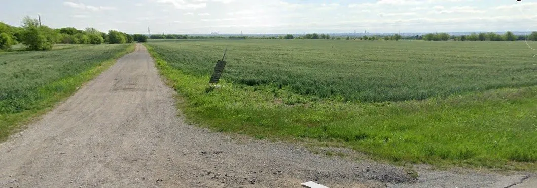
"LongDescription" => "OVER 2,500 FEET OF FRONTAGE ROAD"
"MediaAlteration" => null
"MediaKeyNumeric" => 2003519925691
"PropertySubType" => "Unimproved Land"
"RecordSignature" => -300345380
"PreferredPhotoYN" => null
"ResourceRecordID" => "20729279"
"ShortDescription" => null
"SourceSystemName" => null
"ChangedByMemberID" => null
"ListingPermission" => null
"ResourceRecordKey" => "1086923499"
"ChangedByMemberKey" => null
"MediaClassification" => "PHOTO"
"OriginatingSystemID" => null
"ImageSizeDescription" => null
"SourceSystemMediaKey" => null
"ModificationTimestamp" => "2025-07-04T07:59:08.077-00:00"
"OriginatingSystemName" => "NTR"
"MediaStatusDescription" => null
"OriginatingSystemSubName" => "NTR_NTREIS"
"ResourceRecordKeyNumeric" => 1086923499
"ChangedByMemberKeyNumeric" => null
"OriginatingSystemMediaKey" => "444862704"
"PropertySubTypeAdditional" => "Unimproved Land"
"MediaModificationTimestamp" => "2025-07-04T07:59:08.077-00:00"
"SourceSystemResourceRecordKey" => null
"InternetEntireListingDisplayYN" => true
"OriginatingSystemResourceRecordId" => null
"OriginatingSystemResourceRecordKey" => "444444534"
]
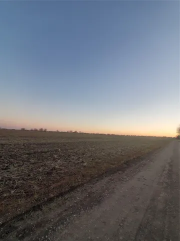
3 => array:57 [
"Order" => 4
"ImageOf" => "View"
"ListAOR" => "Arlington Board Of Realtors"
"MediaKey" => "2003519925687"
"MediaURL" => "https://cdn.realtyfeed.com/cdn/119/1086923499/724874a2e3aa16c318781bb78316d4fd.webp"
"ClassName" => null
"MediaHTML" => null
"MediaSize" => 764981
"MediaType" => "webp"
"Thumbnail" => "https://cdn.realtyfeed.com/cdn/119/1086923499/thumbnail-724874a2e3aa16c318781bb78316d4fd.webp"
"ImageWidth" => null
"Permission" => null
"ImageHeight" => null
"MediaStatus" => null
"SyndicateTo" => "Homes.com,IDX Sites,Realtor.com,RPR,Syndication Allowed"
"ListAgentKey" => "20465799"
"PropertyType" => "Land"
"ResourceName" => "Property"
"ListOfficeKey" => "4511544"
"MediaCategory" => "Photo"
"MediaObjectID" => "1000012740.jpg"
"OffMarketDate" => null
"X_MediaStream" => null
"SourceSystemID" => "TRESTLE"
"StandardStatus" => "Active"
"HumanModifiedYN" => false
"ListOfficeMlsId" => null
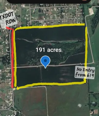
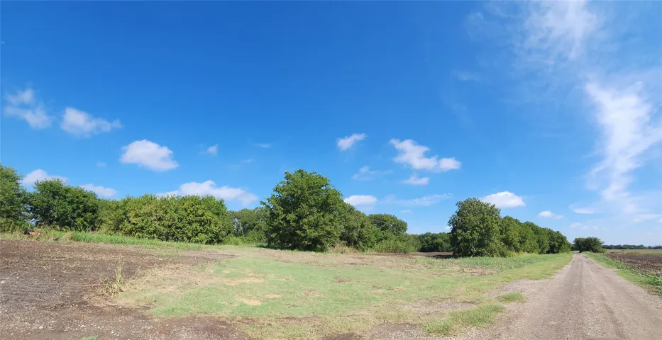
"LongDescription" => "Greenbelt in middle of 191 acres"
"MediaAlteration" => null
"MediaKeyNumeric" => 2003519925687
"PropertySubType" => "Unimproved Land"
"RecordSignature" => -300345380
"PreferredPhotoYN" => null
"ResourceRecordID" => "20729279"
"ShortDescription" => null
"SourceSystemName" => null
"ChangedByMemberID" => null
"ListingPermission" => null
"ResourceRecordKey" => "1086923499"
"ChangedByMemberKey" => null
"MediaClassification" => "PHOTO"
"OriginatingSystemID" => null
"ImageSizeDescription" => null
"SourceSystemMediaKey" => null
"ModificationTimestamp" => "2025-07-04T07:59:08.077-00:00"
"OriginatingSystemName" => "NTR"
"MediaStatusDescription" => null
"OriginatingSystemSubName" => "NTR_NTREIS"
"ResourceRecordKeyNumeric" => 1086923499
"ChangedByMemberKeyNumeric" => null
"OriginatingSystemMediaKey" => "444862700"
"PropertySubTypeAdditional" => "Unimproved Land"
"MediaModificationTimestamp" => "2025-07-04T07:59:08.077-00:00"
"SourceSystemResourceRecordKey" => null
"InternetEntireListingDisplayYN" => true
"OriginatingSystemResourceRecordId" => null
"OriginatingSystemResourceRecordKey" => "444444534"
]
4 => array:57 [
"Order" => 5
"ImageOf" => "Other"
"ListAOR" => "Arlington Board Of Realtors"
"MediaKey" => "2003603676317"
"MediaURL" => "https://cdn.realtyfeed.com/cdn/119/1086923499/460969e35a62049e3652c2d9b148421b.webp"
"ClassName" => null
"MediaHTML" => null
"MediaSize" => 534613
"MediaType" => "webp"
"Thumbnail" => "https://cdn.realtyfeed.com/cdn/119/1086923499/thumbnail-460969e35a62049e3652c2d9b148421b.webp"
"ImageWidth" => null
"Permission" => null
"ImageHeight" => null
"MediaStatus" => null
"SyndicateTo" => "Homes.com,IDX Sites,Realtor.com,RPR,Syndication Allowed"
"ListAgentKey" => "20465799"
"PropertyType" => "Land"
"ResourceName" => "Property"
"ListOfficeKey" => "4511544"
"MediaCategory" => "Photo"
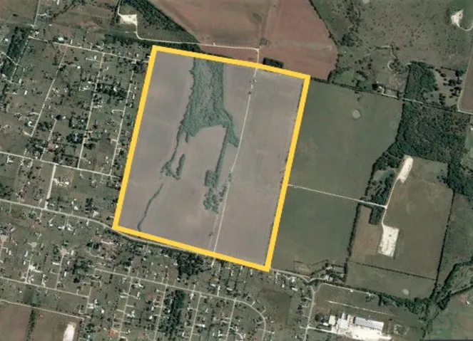
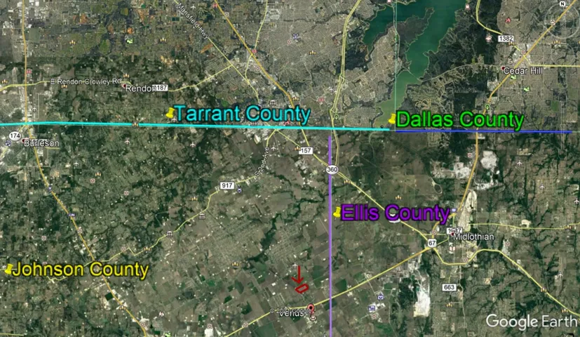
"MediaObjectID" => "Location per counties.jpg"
"OffMarketDate" => null
"X_MediaStream" => null
"SourceSystemID" => "TRESTLE"
"StandardStatus" => "Active"
"HumanModifiedYN" => false
"ListOfficeMlsId" => null
"LongDescription" => "Four Counties, six highways, state park, entertainment, dining, shopping"
"MediaAlteration" => null
"MediaKeyNumeric" => 2003603676317
"PropertySubType" => "Unimproved Land"
"RecordSignature" => -300345380
"PreferredPhotoYN" => null
"ResourceRecordID" => "20729279"
"ShortDescription" => null
"SourceSystemName" => null
"ChangedByMemberID" => null
"ListingPermission" => null
"ResourceRecordKey" => "1086923499"
"ChangedByMemberKey" => null
"MediaClassification" => "PHOTO"
"OriginatingSystemID" => null
"ImageSizeDescription" => null
"SourceSystemMediaKey" => null
"ModificationTimestamp" => "2025-07-04T07:59:08.077-00:00"
"OriginatingSystemName" => "NTR"
"MediaStatusDescription" => null
"OriginatingSystemSubName" => "NTR_NTREIS"
"ResourceRecordKeyNumeric" => 1086923499
"ChangedByMemberKeyNumeric" => null
"OriginatingSystemMediaKey" => "446105893"
"PropertySubTypeAdditional" => "Unimproved Land"
"MediaModificationTimestamp" => "2025-07-04T07:59:08.077-00:00"
"SourceSystemResourceRecordKey" => null
"InternetEntireListingDisplayYN" => true
"OriginatingSystemResourceRecordId" => null
"OriginatingSystemResourceRecordKey" => "444444534"
]
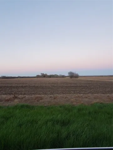
5 => array:57 [
"Order" => 6
"ImageOf" => "View"
"ListAOR" => "Arlington Board Of Realtors"
"MediaKey" => "2003482724799"
"MediaURL" => "https://cdn.realtyfeed.com/cdn/119/1086923499/833a0f1ddd5ff1031a917e13c57d7548.webp"
"ClassName" => null
"MediaHTML" => null
"MediaSize" => 565739
"MediaType" => "webp"
"Thumbnail" => "https://cdn.realtyfeed.com/cdn/119/1086923499/thumbnail-833a0f1ddd5ff1031a917e13c57d7548.webp"
"ImageWidth" => null
"Permission" => null
"ImageHeight" => null
"MediaStatus" => null
"SyndicateTo" => "Homes.com,IDX Sites,Realtor.com,RPR,Syndication Allowed"
"ListAgentKey" => "20465799"
"PropertyType" => "Land"
"ResourceName" => "Property"
"ListOfficeKey" => "4511544"
"MediaCategory" => "Photo"
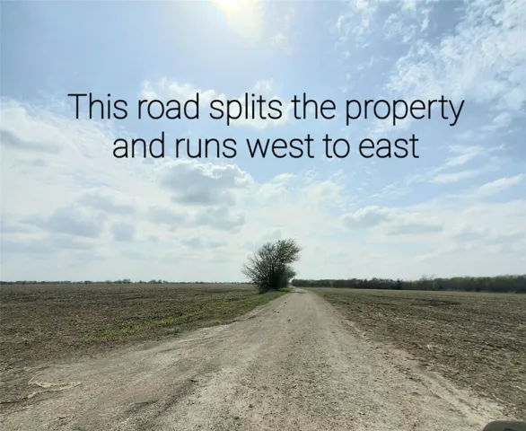
"MediaObjectID" => "road in middle2.jpg"
"OffMarketDate" => null
"X_MediaStream" => null
"SourceSystemID" => "TRESTLE"
"StandardStatus" => "Active"
"HumanModifiedYN" => false
"ListOfficeMlsId" => null
"LongDescription" => "Acreage is flat and mostly cleared for agriculture."
"MediaAlteration" => null
"MediaKeyNumeric" => 2003482724799
"PropertySubType" => "Unimproved Land"
"RecordSignature" => -292037412
"PreferredPhotoYN" => null
"ResourceRecordID" => "20729279"
"ShortDescription" => null
"SourceSystemName" => null
"ChangedByMemberID" => null
"ListingPermission" => null
"ResourceRecordKey" => "1086923499"
"ChangedByMemberKey" => null
"MediaClassification" => "PHOTO"
"OriginatingSystemID" => null
"ImageSizeDescription" => null
"SourceSystemMediaKey" => null
"ModificationTimestamp" => "2025-07-04T07:59:08.077-00:00"
"OriginatingSystemName" => "NTR"
"MediaStatusDescription" => null
"OriginatingSystemSubName" => "NTR_NTREIS"
"ResourceRecordKeyNumeric" => 1086923499
"ChangedByMemberKeyNumeric" => null
"OriginatingSystemMediaKey" => "444609844"
"PropertySubTypeAdditional" => "Unimproved Land"
"MediaModificationTimestamp" => "2025-07-04T07:59:08.077-00:00"
"SourceSystemResourceRecordKey" => null
"InternetEntireListingDisplayYN" => true
"OriginatingSystemResourceRecordId" => null
"OriginatingSystemResourceRecordKey" => "444444534"
]
6 => array:57 [
"Order" => 7
"ImageOf" => "View"
"ListAOR" => "Arlington Board Of Realtors"
"MediaKey" => "2003473088553"
"MediaURL" => "https://cdn.realtyfeed.com/cdn/119/1086923499/6abe2cc9cc99bd9b40f8e891efecc3eb.webp"
"ClassName" => null
"MediaHTML" => null
"MediaSize" => 833416
"MediaType" => "webp"
"Thumbnail" => "https://cdn.realtyfeed.com/cdn/119/1086923499/thumbnail-6abe2cc9cc99bd9b40f8e891efecc3eb.webp"
"ImageWidth" => null
"Permission" => null
"ImageHeight" => null
"MediaStatus" => null
"SyndicateTo" => "Homes.com,IDX Sites,Realtor.com,RPR,Syndication Allowed"
"ListAgentKey" => "20465799"
"PropertyType" => "Land"
"ResourceName" => "Property"
"ListOfficeKey" => "4511544"
"MediaCategory" => "Photo"
"MediaObjectID" => "1.jpg"
"OffMarketDate" => null
"X_MediaStream" => null
"SourceSystemID" => "TRESTLE"
"StandardStatus" => "Active"
"HumanModifiedYN" => false
"ListOfficeMlsId" => null
"LongDescription" => null
"MediaAlteration" => null
"MediaKeyNumeric" => 2003473088553
"PropertySubType" => "Unimproved Land"
"RecordSignature" => -292037412
"PreferredPhotoYN" => null
"ResourceRecordID" => "20729279"
"ShortDescription" => null
"SourceSystemName" => null
"ChangedByMemberID" => null
"ListingPermission" => null
"ResourceRecordKey" => "1086923499"
"ChangedByMemberKey" => null
"MediaClassification" => "PHOTO"
"OriginatingSystemID" => null
"ImageSizeDescription" => null
"SourceSystemMediaKey" => null
"ModificationTimestamp" => "2025-07-04T07:59:08.077-00:00"
"OriginatingSystemName" => "NTR"
"MediaStatusDescription" => null
"OriginatingSystemSubName" => "NTR_NTREIS"
"ResourceRecordKeyNumeric" => 1086923499
"ChangedByMemberKeyNumeric" => null
"OriginatingSystemMediaKey" => "444556146"
"PropertySubTypeAdditional" => "Unimproved Land"
"MediaModificationTimestamp" => "2025-07-04T07:59:08.077-00:00"
"SourceSystemResourceRecordKey" => null
"InternetEntireListingDisplayYN" => true
"OriginatingSystemResourceRecordId" => null
"OriginatingSystemResourceRecordKey" => "444444534"
]
7 => array:57 [
"Order" => 8
"ImageOf" => "View"
"ListAOR" => "Arlington Board Of Realtors"
"MediaKey" => "2003512579536"
"MediaURL" => "https://cdn.realtyfeed.com/cdn/119/1086923499/c9c7c3332c0bc6d1dbc51249d6d22344.webp"
"ClassName" => null
"MediaHTML" => null
"MediaSize" => 188903
"MediaType" => "webp"
"Thumbnail" => "https://cdn.realtyfeed.com/cdn/119/1086923499/thumbnail-c9c7c3332c0bc6d1dbc51249d6d22344.webp"
"ImageWidth" => null
"Permission" => null
"ImageHeight" => null
"MediaStatus" => null
"SyndicateTo" => "Homes.com,IDX Sites,Realtor.com,RPR,Syndication Allowed"
"ListAgentKey" => "20465799"
"PropertyType" => "Land"
"ResourceName" => "Property"
"ListOfficeKey" => "4511544"
"MediaCategory" => "Photo"
"MediaObjectID" => "land3.jpg"
"OffMarketDate" => null
"X_MediaStream" => null
"SourceSystemID" => "TRESTLE"
"StandardStatus" => "Active"
"HumanModifiedYN" => false
"ListOfficeMlsId" => null
"LongDescription" => null
"MediaAlteration" => null
"MediaKeyNumeric" => 2003512579536
"PropertySubType" => "Unimproved Land"
"RecordSignature" => -300345380
"PreferredPhotoYN" => null
"ResourceRecordID" => "20729279"
"ShortDescription" => null
"SourceSystemName" => null
"ChangedByMemberID" => null
"ListingPermission" => null
"ResourceRecordKey" => "1086923499"
"ChangedByMemberKey" => null
"MediaClassification" => "PHOTO"
"OriginatingSystemID" => null
"ImageSizeDescription" => null
"SourceSystemMediaKey" => null
"ModificationTimestamp" => "2025-07-04T07:59:08.077-00:00"
"OriginatingSystemName" => "NTR"
"MediaStatusDescription" => null
"OriginatingSystemSubName" => "NTR_NTREIS"
"ResourceRecordKeyNumeric" => 1086923499
"ChangedByMemberKeyNumeric" => null
"OriginatingSystemMediaKey" => "444783172"
"PropertySubTypeAdditional" => "Unimproved Land"
"MediaModificationTimestamp" => "2025-07-04T07:59:08.077-00:00"
"SourceSystemResourceRecordKey" => null
"InternetEntireListingDisplayYN" => true
"OriginatingSystemResourceRecordId" => null
"OriginatingSystemResourceRecordKey" => "444444534"
]
8 => array:57 [
"Order" => 9
"ImageOf" => "View"
"ListAOR" => "Arlington Board Of Realtors"
"MediaKey" => "2003512579535"
"MediaURL" => "https://cdn.realtyfeed.com/cdn/119/1086923499/1122ece4ce957b7c195270ba0afd65c8.webp"
"ClassName" => null
"MediaHTML" => null
"MediaSize" => 198419
"MediaType" => "webp"
"Thumbnail" => "https://cdn.realtyfeed.com/cdn/119/1086923499/thumbnail-1122ece4ce957b7c195270ba0afd65c8.webp"
"ImageWidth" => null
"Permission" => null
"ImageHeight" => null
"MediaStatus" => null
"SyndicateTo" => "Homes.com,IDX Sites,Realtor.com,RPR,Syndication Allowed"
"ListAgentKey" => "20465799"
"PropertyType" => "Land"
"ResourceName" => "Property"
"ListOfficeKey" => "4511544"
"MediaCategory" => "Photo"
"MediaObjectID" => "land2.jpg"
"OffMarketDate" => null
"X_MediaStream" => null
"SourceSystemID" => "TRESTLE"
"StandardStatus" => "Active"
"HumanModifiedYN" => false
"ListOfficeMlsId" => null
"LongDescription" => null
"MediaAlteration" => null
"MediaKeyNumeric" => 2003512579535
"PropertySubType" => "Unimproved Land"
"RecordSignature" => -300345380
"PreferredPhotoYN" => null
"ResourceRecordID" => "20729279"
"ShortDescription" => null
"SourceSystemName" => null
"ChangedByMemberID" => null
"ListingPermission" => null
"ResourceRecordKey" => "1086923499"
"ChangedByMemberKey" => null
"MediaClassification" => "PHOTO"
"OriginatingSystemID" => null
"ImageSizeDescription" => null
"SourceSystemMediaKey" => null
"ModificationTimestamp" => "2025-07-04T07:59:08.077-00:00"
"OriginatingSystemName" => "NTR"
"MediaStatusDescription" => null
"OriginatingSystemSubName" => "NTR_NTREIS"
"ResourceRecordKeyNumeric" => 1086923499
"ChangedByMemberKeyNumeric" => null
"OriginatingSystemMediaKey" => "444783171"
"PropertySubTypeAdditional" => "Unimproved Land"
"MediaModificationTimestamp" => "2025-07-04T07:59:08.077-00:00"
"SourceSystemResourceRecordKey" => null
"InternetEntireListingDisplayYN" => true
"OriginatingSystemResourceRecordId" => null
"OriginatingSystemResourceRecordKey" => "444444534"
]
9 => array:57 [
"Order" => 10
"ImageOf" => "Aerial View"
"ListAOR" => "Arlington Board Of Realtors"
"MediaKey" => "2003485921574"
"MediaURL" => "https://cdn.realtyfeed.com/cdn/119/1086923499/475c1f1d2c8b95414724346018f0faf0.webp"
"ClassName" => null
"MediaHTML" => null
"MediaSize" => 162026
"MediaType" => "webp"
"Thumbnail" => "https://cdn.realtyfeed.com/cdn/119/1086923499/thumbnail-475c1f1d2c8b95414724346018f0faf0.webp"
"ImageWidth" => null
"Permission" => null
"ImageHeight" => null
"MediaStatus" => null
"SyndicateTo" => "Homes.com,IDX Sites,Realtor.com,RPR,Syndication Allowed"
"ListAgentKey" => "20465799"
"PropertyType" => "Land"
"ResourceName" => "Property"
"ListOfficeKey" => "4511544"
"MediaCategory" => "Photo"
"MediaObjectID" => "1000012640.jpg"
"OffMarketDate" => null
"X_MediaStream" => null
"SourceSystemID" => "TRESTLE"
"StandardStatus" => "Active"
"HumanModifiedYN" => false
"ListOfficeMlsId" => null
"LongDescription" => "Map location"
"MediaAlteration" => null
"MediaKeyNumeric" => 2003485921574
"PropertySubType" => "Unimproved Land"
"RecordSignature" => -292037412
"PreferredPhotoYN" => null
"ResourceRecordID" => "20729279"
"ShortDescription" => null
"SourceSystemName" => null
"ChangedByMemberID" => null
"ListingPermission" => null
"ResourceRecordKey" => "1086923499"
"ChangedByMemberKey" => null
"MediaClassification" => "PHOTO"
"OriginatingSystemID" => null
"ImageSizeDescription" => null
"SourceSystemMediaKey" => null
"ModificationTimestamp" => "2025-07-04T07:59:08.077-00:00"
"OriginatingSystemName" => "NTR"
"MediaStatusDescription" => null
"OriginatingSystemSubName" => "NTR_NTREIS"
"ResourceRecordKeyNumeric" => 1086923499
"ChangedByMemberKeyNumeric" => null
"OriginatingSystemMediaKey" => "444618940"
"PropertySubTypeAdditional" => "Unimproved Land"
"MediaModificationTimestamp" => "2025-07-04T07:59:08.077-00:00"
"SourceSystemResourceRecordKey" => null
"InternetEntireListingDisplayYN" => true
"OriginatingSystemResourceRecordId" => null
"OriginatingSystemResourceRecordKey" => "444444534"
]
10 => array:57 [
"Order" => 11
"ImageOf" => "View"
"ListAOR" => "Arlington Board Of Realtors"
"MediaKey" => "2003473088555"
"MediaURL" => "https://cdn.realtyfeed.com/cdn/119/1086923499/44bbb414f629eb714f863954674ca0ec.webp"
"ClassName" => null
"MediaHTML" => null
"MediaSize" => 332147
"MediaType" => "webp"
"Thumbnail" => "https://cdn.realtyfeed.com/cdn/119/1086923499/thumbnail-44bbb414f629eb714f863954674ca0ec.webp"
"ImageWidth" => null
"Permission" => null
"ImageHeight" => null
"MediaStatus" => null
"SyndicateTo" => "Homes.com,IDX Sites,Realtor.com,RPR,Syndication Allowed"
"ListAgentKey" => "20465799"
"PropertyType" => "Land"
"ResourceName" => "Property"
"ListOfficeKey" => "4511544"
"MediaCategory" => "Photo"
"MediaObjectID" => "20210318_194525.jpg"
"OffMarketDate" => null
"X_MediaStream" => null
"SourceSystemID" => "TRESTLE"
"StandardStatus" => "Active"
"HumanModifiedYN" => false
"ListOfficeMlsId" => null
"LongDescription" => null
"MediaAlteration" => null
"MediaKeyNumeric" => 2003473088555
"PropertySubType" => "Unimproved Land"
"RecordSignature" => -292037412
"PreferredPhotoYN" => null
"ResourceRecordID" => "20729279"
"ShortDescription" => null
"SourceSystemName" => null
"ChangedByMemberID" => null
"ListingPermission" => null
"ResourceRecordKey" => "1086923499"
"ChangedByMemberKey" => null
"MediaClassification" => "PHOTO"
"OriginatingSystemID" => null
"ImageSizeDescription" => null
"SourceSystemMediaKey" => null
"ModificationTimestamp" => "2025-07-04T07:59:08.077-00:00"
"OriginatingSystemName" => "NTR"
"MediaStatusDescription" => null
"OriginatingSystemSubName" => "NTR_NTREIS"
"ResourceRecordKeyNumeric" => 1086923499
"ChangedByMemberKeyNumeric" => null
"OriginatingSystemMediaKey" => "444556147"
"PropertySubTypeAdditional" => "Unimproved Land"
"MediaModificationTimestamp" => "2025-07-04T07:59:08.077-00:00"
"SourceSystemResourceRecordKey" => null
"InternetEntireListingDisplayYN" => true
"OriginatingSystemResourceRecordId" => null
"OriginatingSystemResourceRecordKey" => "444444534"
]
11 => array:57 [
"Order" => 12
"ImageOf" => "View"
"ListAOR" => "Arlington Board Of Realtors"
"MediaKey" => "2003482724800"
"MediaURL" => "https://cdn.realtyfeed.com/cdn/119/1086923499/7bf7dedaf67d7361a3bfb120fc59481a.webp"
"ClassName" => null
"MediaHTML" => null
"MediaSize" => 333926
"MediaType" => "webp"
"Thumbnail" => "https://cdn.realtyfeed.com/cdn/119/1086923499/thumbnail-7bf7dedaf67d7361a3bfb120fc59481a.webp"
"ImageWidth" => null
"Permission" => null
"ImageHeight" => null
"MediaStatus" => null
"SyndicateTo" => "Homes.com,IDX Sites,Realtor.com,RPR,Syndication Allowed"
"ListAgentKey" => "20465799"
"PropertyType" => "Land"
"ResourceName" => "Property"
"ListOfficeKey" => "4511544"
"MediaCategory" => "Photo"
"MediaObjectID" => "south side of gravel.jpg"
"OffMarketDate" => null
"X_MediaStream" => null
"SourceSystemID" => "TRESTLE"
"StandardStatus" => "Active"
"HumanModifiedYN" => false
"ListOfficeMlsId" => null
"LongDescription" => null
"MediaAlteration" => null
"MediaKeyNumeric" => 2003482724800
"PropertySubType" => "Unimproved Land"
"RecordSignature" => -292037412
"PreferredPhotoYN" => null
"ResourceRecordID" => "20729279"
"ShortDescription" => null
"SourceSystemName" => null
"ChangedByMemberID" => null
"ListingPermission" => null
"ResourceRecordKey" => "1086923499"
"ChangedByMemberKey" => null
"MediaClassification" => "PHOTO"
"OriginatingSystemID" => null
"ImageSizeDescription" => null
"SourceSystemMediaKey" => null
"ModificationTimestamp" => "2025-07-04T07:59:08.077-00:00"
"OriginatingSystemName" => "NTR"
"MediaStatusDescription" => null
"OriginatingSystemSubName" => "NTR_NTREIS"
"ResourceRecordKeyNumeric" => 1086923499
"ChangedByMemberKeyNumeric" => null
"OriginatingSystemMediaKey" => "444609845"
"PropertySubTypeAdditional" => "Unimproved Land"
"MediaModificationTimestamp" => "2025-07-04T07:59:08.077-00:00"
"SourceSystemResourceRecordKey" => null
"InternetEntireListingDisplayYN" => true
"OriginatingSystemResourceRecordId" => null
"OriginatingSystemResourceRecordKey" => "444444534"
]
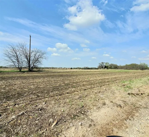
12 => array:57 [
"Order" => 13
"ImageOf" => "Other"
"ListAOR" => "Arlington Board Of Realtors"
"MediaKey" => "2003485888400"
"MediaURL" => "https://cdn.realtyfeed.com/cdn/119/1086923499/74f4b4206bc918aed682d3615bd8b648.webp"
"ClassName" => null
"MediaHTML" => null
"MediaSize" => 40343
"MediaType" => "webp"
"Thumbnail" => "https://cdn.realtyfeed.com/cdn/119/1086923499/thumbnail-74f4b4206bc918aed682d3615bd8b648.webp"
"ImageWidth" => null
"Permission" => null
"ImageHeight" => null
"MediaStatus" => null
"SyndicateTo" => "Homes.com,IDX Sites,Realtor.com,RPR,Syndication Allowed"
"ListAgentKey" => "20465799"
"PropertyType" => "Land"
"ResourceName" => "Property"
"ListOfficeKey" => "4511544"
"MediaCategory" => "Photo"
"MediaObjectID" => "Screenshot_20240916_084948_Yahoo Mail.jpg"
"OffMarketDate" => null
"X_MediaStream" => null
"SourceSystemID" => "TRESTLE"
"StandardStatus" => "Active"
"HumanModifiedYN" => false
"ListOfficeMlsId" => null
"LongDescription" => "TXDOT ROW along front of land ON 157"
"MediaAlteration" => null
"MediaKeyNumeric" => 2003485888400
"PropertySubType" => "Unimproved Land"
"RecordSignature" => -292037412
"PreferredPhotoYN" => null
"ResourceRecordID" => "20729279"
"ShortDescription" => null
"SourceSystemName" => null
"ChangedByMemberID" => null
"ListingPermission" => null
"ResourceRecordKey" => "1086923499"
"ChangedByMemberKey" => null
"MediaClassification" => "PHOTO"
"OriginatingSystemID" => null
"ImageSizeDescription" => null
"SourceSystemMediaKey" => null
"ModificationTimestamp" => "2025-07-04T07:59:08.077-00:00"
"OriginatingSystemName" => "NTR"
"MediaStatusDescription" => null
"OriginatingSystemSubName" => "NTR_NTREIS"
"ResourceRecordKeyNumeric" => 1086923499
"ChangedByMemberKeyNumeric" => null
"OriginatingSystemMediaKey" => "444618728"
"PropertySubTypeAdditional" => "Unimproved Land"
"MediaModificationTimestamp" => "2025-07-04T07:59:08.077-00:00"
"SourceSystemResourceRecordKey" => null
"InternetEntireListingDisplayYN" => true
"OriginatingSystemResourceRecordId" => null
"OriginatingSystemResourceRecordKey" => "444444534"
]
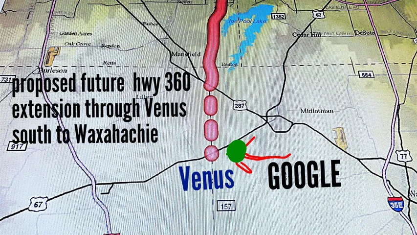
13 => array:57 [
"Order" => 14
"ImageOf" => "Other"
"ListAOR" => "Arlington Board Of Realtors"
"MediaKey" => "2003506613135"
"MediaURL" => "https://cdn.realtyfeed.com/cdn/119/1086923499/d491372bea71fbd9868c3de8db64ebe7.webp"
"ClassName" => null
"MediaHTML" => null
"MediaSize" => 1470304
"MediaType" => "webp"
"Thumbnail" => "https://cdn.realtyfeed.com/cdn/119/1086923499/thumbnail-d491372bea71fbd9868c3de8db64ebe7.webp"
"ImageWidth" => null
"Permission" => null
"ImageHeight" => null
"MediaStatus" => null
"SyndicateTo" => "Homes.com,IDX Sites,Realtor.com,RPR,Syndication Allowed"
"ListAgentKey" => "20465799"
"PropertyType" => "Land"
"ResourceName" => "Property"
"ListOfficeKey" => "4511544"
"MediaCategory" => "Photo"
"MediaObjectID" => "IMG_20190814_181742.jpg"
"OffMarketDate" => null
"X_MediaStream" => null
"SourceSystemID" => "TRESTLE"
"StandardStatus" => "Active"
"HumanModifiedYN" => false
"ListOfficeMlsId" => null
"LongDescription" => "Possible extension of Hey 360 south through Venus south to Hillsboro."
"MediaAlteration" => null
"MediaKeyNumeric" => 2003506613135
"PropertySubType" => "Unimproved Land"
"RecordSignature" => -300345380
"PreferredPhotoYN" => null
"ResourceRecordID" => "20729279"
"ShortDescription" => null
"SourceSystemName" => null
"ChangedByMemberID" => null
"ListingPermission" => null
"ResourceRecordKey" => "1086923499"
"ChangedByMemberKey" => null
"MediaClassification" => "PHOTO"
"OriginatingSystemID" => null
"ImageSizeDescription" => null
"SourceSystemMediaKey" => null
"ModificationTimestamp" => "2025-07-04T07:59:08.077-00:00"
"OriginatingSystemName" => "NTR"
"MediaStatusDescription" => null
"OriginatingSystemSubName" => "NTR_NTREIS"
"ResourceRecordKeyNumeric" => 1086923499
"ChangedByMemberKeyNumeric" => null
"OriginatingSystemMediaKey" => "444733191"
"PropertySubTypeAdditional" => "Unimproved Land"
"MediaModificationTimestamp" => "2025-07-04T07:59:08.077-00:00"
"SourceSystemResourceRecordKey" => null
"InternetEntireListingDisplayYN" => true
"OriginatingSystemResourceRecordId" => null
"OriginatingSystemResourceRecordKey" => "444444534"
]
14 => array:57 [
"Order" => 15
"ImageOf" => "View"
"ListAOR" => "Arlington Board Of Realtors"
"MediaKey" => "2003508299607"
"MediaURL" => "https://cdn.realtyfeed.com/cdn/119/1086923499/c0f6d880b9f7bb9b5aa0f259618d85e5.webp"
"ClassName" => null
"MediaHTML" => null
"MediaSize" => 874060
"MediaType" => "webp"
"Thumbnail" => "https://cdn.realtyfeed.com/cdn/119/1086923499/thumbnail-c0f6d880b9f7bb9b5aa0f259618d85e5.webp"
"ImageWidth" => null
"Permission" => null
"ImageHeight" => null
"MediaStatus" => null
…43
]
15 => array:57 [ …57]
16 => array:57 [ …57]
17 => array:57 [ …57]
18 => array:57 [ …57]
]
+"ID": "27872"
}
2 => Realtyna\MlsOnTheFly\Components\CloudPost\SubComponents\RFClient\SDK\RF\Entities\RFProperty {#4692
+post_id: "119964"
+post_author: 1
+"ListingKey": "1119711824"
+"ListingId": "21007298"
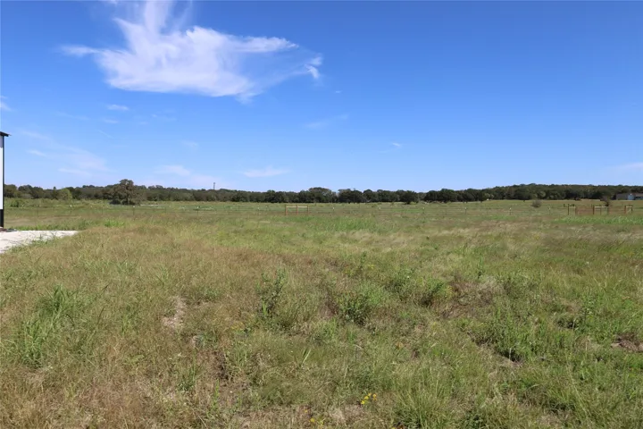
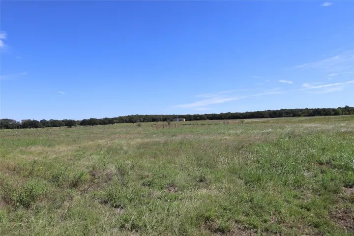
+"PropertyType": "Land"
+"PropertySubType": "Unimproved Land"
+"StandardStatus": "Active"
+"ModificationTimestamp": "2025-07-22T01:11:06Z"
+"RFModificationTimestamp": "2025-07-22T05:03:10Z"
+"ListPrice": 165000.0
+"BathroomsTotalInteger": 0
+"BathroomsHalf": 0
+"BedroomsTotal": 0
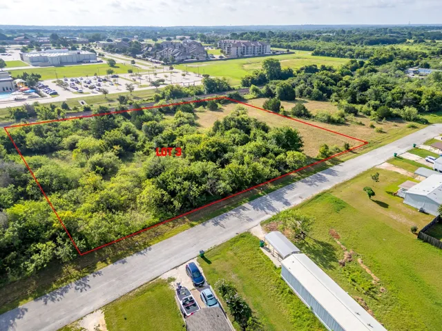
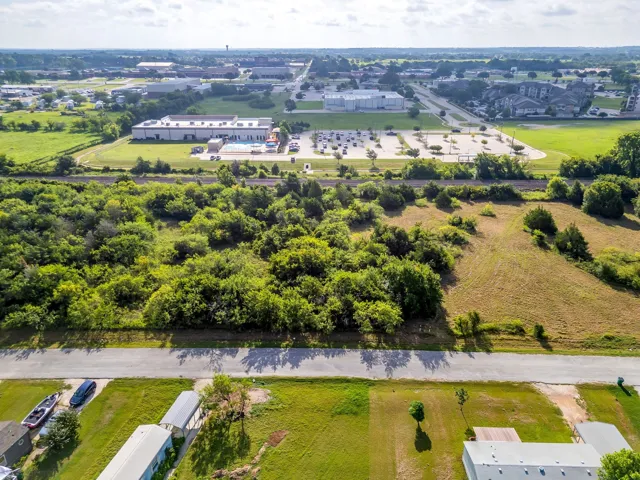
+"LotSizeArea": 3.3
+"LivingArea": 0
+"BuildingAreaTotal": 0
+"City": "Alvarado"
+"PostalCode": "76009"
+"UnparsedAddress": "3960 Cr 405, Alvarado, Texas 76009"
+"Coordinates": array:2 [
0 => -97.250163
1 => 32.357043
]
+"Latitude": 32.357043
+"Longitude": -97.250163
+"YearBuilt": 0
+"InternetAddressDisplayYN": true
+"FeedTypes": "IDX"
+"ListAgentFullName": "Leslie Majors"
+"ListOfficeName": "Legacy Realty Group"
+"ListAgentMlsId": "0521444"
+"ListOfficeMlsId": "LJJM01"
+"OriginatingSystemName": "NTR"
+"PublicRemarks": "READY TO CLOSE!! Come build or place your home on this beautiful 3.300 acre property! No mobile homes. 1500 sqft min, no unregistered vehicles visible from the road WATER TAPS ARE COMPLETE AND READY FOR METER. Bring your animals, build your barns, and enjoy the quiet country surroundings. Property has been owned and farmed by the same family for over100 years! Schedule your viewing today!"
+"AttributionContact": "972-905-6333"
+"CLIP": 8830136827
+"Country": "US"
+"CountyOrParish": "Johnson"
+"CreationDate": "2025-07-21T23:27:43.910382+00:00"
+"CurrentUse": "Other"
+"DevelopmentStatus": "Other"
+"Directions": "From 67 South. Left on Baugh St, Left on S Sparks St, Left on S Parkway Dr, Right on IH-35V BL, Right on FM 2415, Right on CR 405."
+"ElementarySchoolDistrict": "Alvarado ISD"
+"HighSchool": "Alvarado"
+"HighSchoolDistrict": "Alvarado ISD"
+"RFTransactionType": "For Sale"
+"InternetEntireListingDisplayYN": true
+"ListAgentAOR": "Arlington Board Of Realtors"
+"ListAgentDirectPhone": "972-921-6880"
+"ListAgentEmail": "leslie@lesliemajors.com"
+"ListAgentFirstName": "Leslie"
+"ListAgentKey": "20479959"
+"ListAgentKeyNumeric": "20479959"
+"ListAgentLastName": "Majors"
+"ListOfficeKey": "4510246"
+"ListOfficeKeyNumeric": "4510246"
+"ListOfficePhone": "972-905-6333"
+"ListingAgreement": "Exclusive Right To Sell"
+"ListingContractDate": "2025-07-21"
+"ListingKeyNumeric": 1119711824
+"LockBoxType": "None"
+"LotFeatures": "Acreage"
+"LotSizeAcres": 3.3
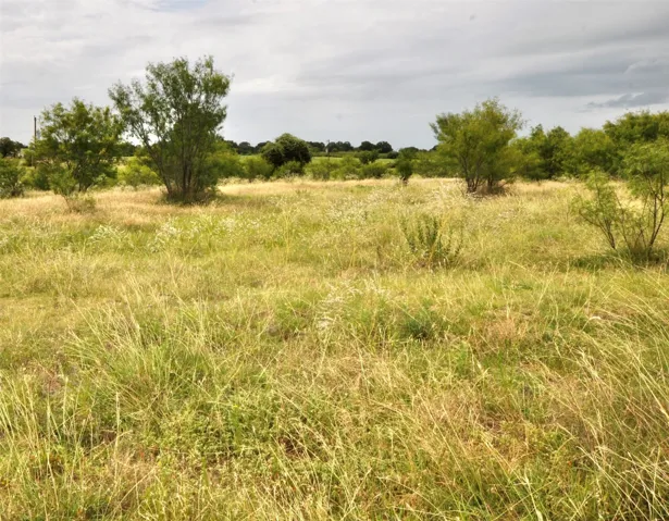
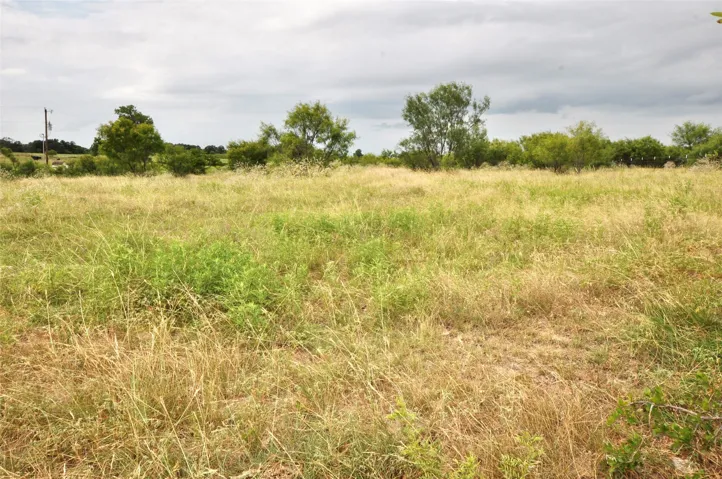
+"LotSizeSquareFeet": 143748.0
+"MajorChangeTimestamp": "2025-07-21T14:44:41Z"
+"MlsStatus": "Active"
+"OriginalListPrice": 165000.0
+"OriginatingSystemKey": "459572091"
+"OwnerName": "Shannon Heeter"
+"ParcelNumber": "126020202130"
+"PhotosChangeTimestamp": "2025-07-21T19:46:33Z"
+"PhotosCount": 3
+"Possession": "Close Of Escrow"
+"PostalCodePlus4": "3002"
+"PriceChangeTimestamp": "2025-07-21T14:44:41Z"
+"PrivateRemarks": "Seller does not own mineral rights, so they do not convey"
+"ShowingContactPhone": "(800) 257-1242"
+"ShowingContactType": "Showing Service"
+"ShowingRequirements": "Showing Service"
+"SpecialListingConditions": "Standard"
+"StateOrProvince": "TX"
+"StatusChangeTimestamp": "2025-07-21T14:44:41Z"
+"StreetName": "CR 405"
+"StreetNumber": "3960"
+"StreetNumberNumeric": "3960"
+"SubdivisionName": "none"
+"SyndicateTo": "Homes.com,IDX Sites,Realtor.com,RPR,Syndication Allowed"
+"TaxAnnualAmount": "31.0"
+"TaxLegalDescription": "ABST 202 Tract 3: 3.480 Acres"
+"Utilities": "Other"
+"VirtualTourURLUnbranded": "https://www.propertypanorama.com/instaview/ntreis/21007298"
+"ZoningDescription": "Currently AG"
+"Restrictions": "Building Restrictions,No Mobile Home,Other Restrictions"
+"HumanModifiedYN": false
+"GarageDimensions": ",,"
+"TitleCompanyPhone": "469-699-4099"
+"TitleCompanyAddress": "16 Northgate Dr, Ste 200"
+"TitleCompanyPreferred": "Diversified- Kim Barr"
+"OriginatingSystemSubName": "NTR_NTREIS"
+"@odata.id": "https://api.realtyfeed.com/reso/odata/Property('1119711824')"
+"provider_name": "NTREIS"
+"RecordSignature": -864216838
+"UniversalParcelId": "urn:reso:upi:2.0:US:48251:126020202130"
+"CountrySubdivision": "48251"
+"Media": array:3 [
0 => array:57 [ …57]
1 => array:57 [ …57]
2 => array:57 [ …57]
]
+"ID": "119964"
}
3 => Realtyna\MlsOnTheFly\Components\CloudPost\SubComponents\RFClient\SDK\RF\Entities\RFProperty {#4688
+post_id: "119856"
+post_author: 1
+"ListingKey": "1119722329"
+"ListingId": "21007665"
+"PropertyType": "Land"
+"PropertySubType": "Unimproved Land"
+"StandardStatus": "Active"
+"ModificationTimestamp": "2025-07-22T06:10:45Z"
+"RFModificationTimestamp": "2025-07-22T06:17:35Z"
+"ListPrice": 32000.0
+"BathroomsTotalInteger": 0
+"BathroomsHalf": 0
+"BedroomsTotal": 0
+"LotSizeArea": 0.144
+"LivingArea": 0
+"BuildingAreaTotal": 0
+"City": "Fort Worth"
+"PostalCode": "76115"
+"UnparsedAddress": "1345 Blodgett Avenue, Fort Worth, Texas 76115"
+"Coordinates": array:2 [
0 => -97.307688
1 => 32.690452
]
+"Latitude": 32.690452
+"Longitude": -97.307688
+"YearBuilt": 0
+"InternetAddressDisplayYN": true
+"FeedTypes": "IDX"
+"ListAgentFullName": "Mariela Borjon"
+"ListOfficeName": "Su Kaza Realty, LLC"
+"ListAgentMlsId": "0712726"
+"ListOfficeMlsId": "SUKR00FW"
+"OriginatingSystemName": "NTR"
+"PublicRemarks": "Check out 1341 Blodgett and 1345 Blodgett Avenue two cleared lots side by side ready for your next project! Alot of new construction in the area! Minutes from Downtown FW, highways and retail."
+"AccessCode": "NO gate"
+"AttributionContact": "817-889-3522"
+"CLIP": 4906267037
+"Country": "US"
+"CountyOrParish": "Tarrant"
+"CreationDate": "2025-07-22T01:47:48.599963+00:00"
+"CumulativeDaysOnMarket": 1
+"Directions": "See GPS, lots will be at the end of the street to the left."
+"ElementarySchool": "Carterpark"
+"ElementarySchoolDistrict": "Fort Worth ISD"
+"HighSchool": "Wyatt Od"
+"HighSchoolDistrict": "Fort Worth ISD"
+"RFTransactionType": "For Sale"
+"InternetEntireListingDisplayYN": true
+"ListAgentAOR": "Greater Fort Worth Association Of Realtors"
+"ListAgentDirectPhone": "817-714-5173"
+"ListAgentEmail": "mariela@sukaza Realty.com"
+"ListAgentFirstName": "Mariela"
+"ListAgentKey": "20478260"
+"ListAgentKeyNumeric": "20478260"
+"ListAgentLastName": "Borjon"
+"ListAgentMiddleName": "I"
+"ListOfficeKey": "4507202"
+"ListOfficeKeyNumeric": "4507202"
+"ListOfficePhone": "817-889-3522"
+"ListingAgreement": "Exclusive Right With Exception"
+"ListingContractDate": "2025-07-21"
+"ListingKeyNumeric": 1119722329
+"ListingTerms": "Cash, Conventional"
+"LockBoxType": "None"
+"LotFeatures": "Corner Lot,City Lot"
+"LotSizeAcres": 0.144
+"LotSizeSquareFeet": 6272.64
+"MajorChangeTimestamp": "2025-07-21T18:43:54Z"
+"MiddleOrJuniorSchool": "Forest Oak"
+"MlsStatus": "Active"
+"OriginalListPrice": 32000.0
+"OriginatingSystemKey": "459584509"
+"OwnerName": "see tax record"
+"ParcelNumber": "03378365"
+"PhotosChangeTimestamp": "2025-07-21T23:45:30Z"
+"PhotosCount": 3
+"Possession": "Close Of Escrow"
+"PostalCodePlus4": "1715"
+"PriceChangeTimestamp": "2025-07-21T18:43:54Z"
+"PrivateRemarks": "Flood zone Code AE, buyer and buyers agent do your due diligence."
+"ShowingInstructions": "No Gates just drive by and see"
+"SpecialListingConditions": "Standard"
+"StateOrProvince": "TX"
+"StatusChangeTimestamp": "2025-07-21T18:43:54Z"
+"StreetName": "Blodgett"
+"StreetNumber": "1345"
+"StreetNumberNumeric": "1345"
+"StreetSuffix": "Avenue"
+"SubdivisionName": "Weisenberger Add"
+"SyndicateTo": "Homes.com,IDX Sites,Realtor.com,RPR,Syndication Allowed"
+"TaxAnnualAmount": "358.0"
+"TaxBlock": "3"
+"TaxLegalDescription": "WEISENBERGER ADDITION #4 BLOCK 3 LOT 17"
+"TaxLot": "17"
+"Utilities": "Other"
+"VirtualTourURLUnbranded": "https://www.propertypanorama.com/instaview/ntreis/21007665"
+"ZoningDescription": "TAD is reflecting as Residential"
+"Restrictions": "Unknown"
+"HumanModifiedYN": false
+"GarageDimensions": ",,"
+"TitleCompanyPhone": "817-810-9594"
+"TitleCompanyAddress": "River Run FW"
+"TitleCompanyPreferred": "Kathy Montes Providence"
+"OriginatingSystemSubName": "NTR_NTREIS"
+"@odata.id": "https://api.realtyfeed.com/reso/odata/Property('1119722329')"
+"provider_name": "NTREIS"
+"RecordSignature": -1048661077
+"UniversalParcelId": "urn:reso:upi:2.0:US:48439:03378365"
+"CountrySubdivision": "48439"
+"Media": array:3 [
0 => array:57 [ …57]
1 => array:57 [ …57]
2 => array:57 [ …57]
]
+"ID": "119856"
}
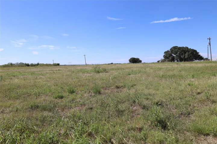
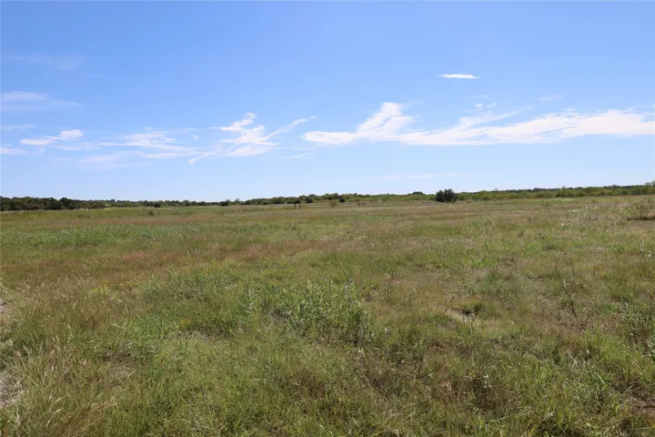
4 => Realtyna\MlsOnTheFly\Components\CloudPost\SubComponents\RFClient\SDK\RF\Entities\RFProperty {#4690
+post_id: "121258"
+post_author: 1
+"ListingKey": "1119106344"
+"ListingId": "20998591"
+"PropertyType": "Land"
+"PropertySubType": "Unimproved Land"
+"StandardStatus": "Active"
+"ModificationTimestamp": "2025-07-22T06:10:45Z"
+"RFModificationTimestamp": "2025-07-22T06:33:15Z"
+"ListPrice": 100000.0
+"BathroomsTotalInteger": 0
+"BathroomsHalf": 0
+"BedroomsTotal": 0
+"LotSizeArea": 2.302
+"LivingArea": 0
+"BuildingAreaTotal": 0
+"City": "Joshua"
+"PostalCode": "76058"
+"UnparsedAddress": "Tract 3 Joshua Ryan Drive, Joshua, Texas 76058"
+"Coordinates": array:2 [
0 => -97.39024
1 => 32.450089
]
+"Latitude": 32.450089
+"Longitude": -97.39024
+"YearBuilt": 0
+"InternetAddressDisplayYN": true
+"FeedTypes": "IDX"
+"ListAgentFullName": "Amy Rumfield"
+"ListOfficeName": "All City Real Estate, Ltd. Co."
+"ListAgentMlsId": "0749602"
+"ListOfficeMlsId": "ALLC01"
+"OriginatingSystemName": "NTR"
+"PublicRemarks": "Hard to Find Treed Acreage in Joshua ISD –Tract 3- 2.302 acres Don’t miss this rare opportunity to own beautiful, tree studded acreage in the highly sought after Joshua Independent School District! Nestled in a quiet rural area just minutes from town, this picturesque property offers both privacy and convenience in a serene, natural setting. Scattered mature trees provide shade, character, and the perfect backdrop for your dream home, barndominium, or weekend getaway. Whether you're looking to build, invest, or create your own private retreat, the possibilities are endless. Water and sewer is available through Johnson County Special Utility District, or you can install your own well and septic. Acreage like this complete with trees and located in Joshua ISD is hard to find."
+"AttributionContact": "866-277-6005"
+"Country": "US"
+"CountyOrParish": "Johnson"
+"CreationDate": "2025-07-12T12:46:26.180957+00:00"
+"CumulativeDaysOnMarket": 10
+"Directions": "From Burleson on SH 174 go 6 miles and turn right on E. 14Th St. Turn left on Eddy Ave. Turn left on Ranchette Dr. Turn left on SW 24th St. 1001 Joshua Ryan Dr. will be on your left. Signs marking each tract."
+"ElementarySchool": "Staples"
+"ElementarySchoolDistrict": "Joshua ISD"
+"HighSchool": "Joshua"
+"HighSchoolDistrict": "Joshua ISD"
+"RFTransactionType": "For Sale"
+"InternetAutomatedValuationDisplayYN": true
+"InternetConsumerCommentYN": true
+"InternetEntireListingDisplayYN": true
+"ListAgentAOR": "Metrotex Association of Realtors Inc"
+"ListAgentDirectPhone": "817-313-0485"
+"ListAgentEmail": "dusty@rumfields.com"
+"ListAgentFirstName": "Amy"
+"ListAgentKey": "20444637"
+"ListAgentKeyNumeric": "20444637"
+"ListAgentLastName": "Rumfield"
+"ListAgentMiddleName": "B"
+"ListOfficeKey": "4511807"
+"ListOfficeKeyNumeric": "4511807"
+"ListOfficePhone": "866-277-6005"
+"ListingAgreement": "Exclusive Right To Sell"
+"ListingContractDate": "2025-07-12"
+"ListingKeyNumeric": 1119106344
+"LockBoxType": "None"
+"LotFeatures": "Acreage,City Lot"
+"LotSizeAcres": 2.302
+"LotSizeSquareFeet": 100275.12
+"MajorChangeTimestamp": "2025-07-12T07:44:31Z"
+"MiddleOrJuniorSchool": "Loflin"
+"MlsStatus": "Active"
+"OriginalListPrice": 100000.0
+"OriginatingSystemKey": "459194562"
+"OwnerName": "Rumfield Properties, Inc."
+"ParcelNumber": "126017303496"
+"PhotosChangeTimestamp": "2025-07-21T19:13:30Z"
+"PhotosCount": 10
+"Possession": "Close Of Escrow"
+"PriceChangeTimestamp": "2025-07-12T07:44:31Z"
+"PrivateRemarks": "Listing agent is related to seller. Buyers agent to verify all information in this listing"
+"ShowingInstructions": "Go and show"
+"SpecialListingConditions": "Standard"
+"StateOrProvince": "TX"
+"StatusChangeTimestamp": "2025-07-12T07:44:31Z"
+"StreetName": "Joshua Ryan"
+"StreetNumber": "Tract 3"
+"StreetSuffix": "Drive"
+"SubdivisionName": "G Casseland"
+"SyndicateTo": "Homes.com,IDX Sites,Realtor.com,RPR,Syndication Allowed"
+"TaxAnnualAmount": "26.0"
+"TaxBlock": "ABST 173"
+"TaxLegalDescription": "ABST 173 TR 3 G CASSELAND"
+"TaxLot": "Tract"
+"Utilities": "Other"
+"VirtualTourURLUnbranded": "https://www.propertypanorama.com/instaview/ntreis/20998591"
+"ZoningDescription": "Residential"
+"Restrictions": "Other Restrictions"
+"HumanModifiedYN": false
+"GarageDimensions": ",,"
+"OriginatingSystemSubName": "NTR_NTREIS"
+"@odata.id": "https://api.realtyfeed.com/reso/odata/Property('1119106344')"
+"provider_name": "NTREIS"
+"RecordSignature": -122846924
+"UniversalParcelId": "urn:reso:upi:2.0:US:48251:126017303496"
+"CountrySubdivision": "48251"
+"Media": array:10 [
0 => array:57 [ …57]
1 => array:57 [ …57]
2 => array:57 [ …57]
3 => array:57 [ …57]
4 => array:57 [ …57]
5 => array:57 [ …57]
6 => array:57 [ …57]
7 => array:57 [ …57]
8 => array:57 [ …57]
9 => array:57 [ …57]
]
+"ID": "121258"
}
5 => Realtyna\MlsOnTheFly\Components\CloudPost\SubComponents\RFClient\SDK\RF\Entities\RFProperty {#4743
+post_id: "42538"
+post_author: 1
+"ListingKey": "1109536987"
+"ListingId": "20888138"
+"PropertyType": "Land"
+"PropertySubType": "Unimproved Land"
+"StandardStatus": "Active"
+"ModificationTimestamp": "2025-07-22T04:09:40Z"
+"RFModificationTimestamp": "2025-07-22T05:29:56Z"
+"ListPrice": 720000.0
+"BathroomsTotalInteger": 0
+"BathroomsHalf": 0
+"BedroomsTotal": 0
+"LotSizeArea": 60.0
+"LivingArea": 0
+"BuildingAreaTotal": 0
+"City": "Meridian"
+"PostalCode": "76665"
+"UnparsedAddress": "Tbd Cr 2371, Meridian, Texas 76665"
+"Coordinates": array:2 [
0 => -97.7517172
1 => 31.98918956
]
+"Latitude": 31.98918956
+"Longitude": -97.7517172
+"YearBuilt": 0
+"InternetAddressDisplayYN": true
+"FeedTypes": "IDX"
+"ListAgentFullName": "Jeanie Cosper"
+"ListOfficeName": "Jeanie Cosper Real Estate"
+"ListAgentMlsId": "0461574"
+"ListOfficeMlsId": "JCRE00SV"
+"OriginatingSystemName": "NTR"
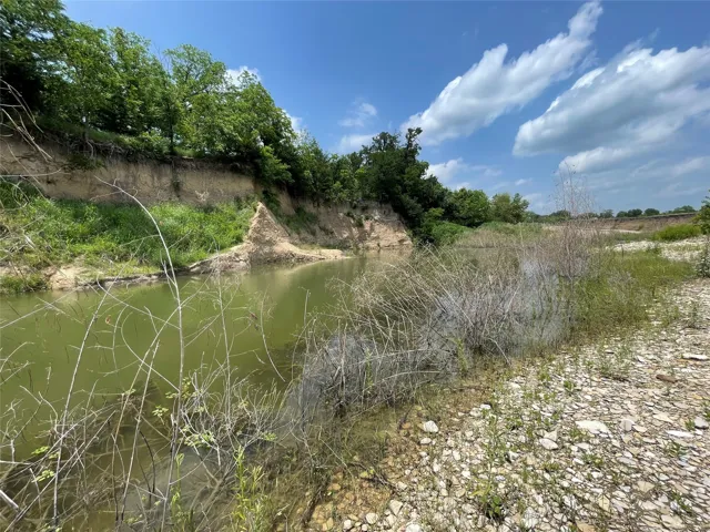
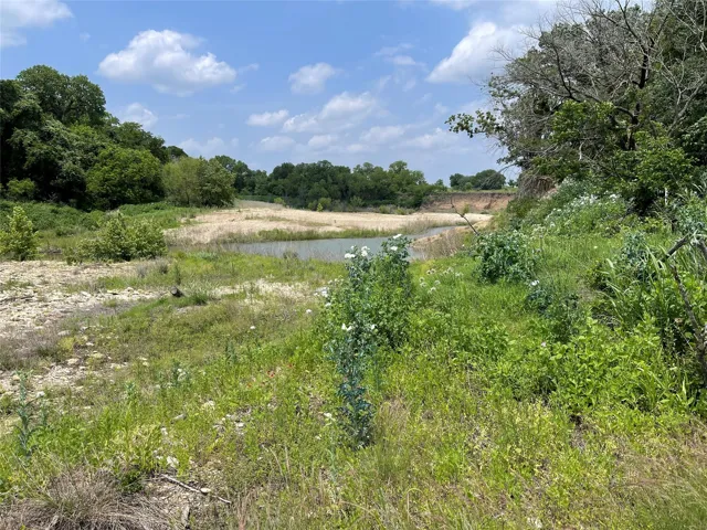
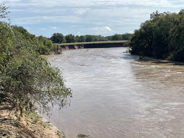
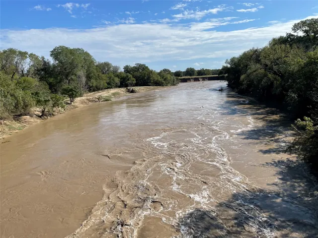
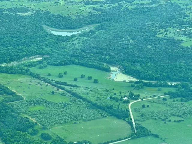
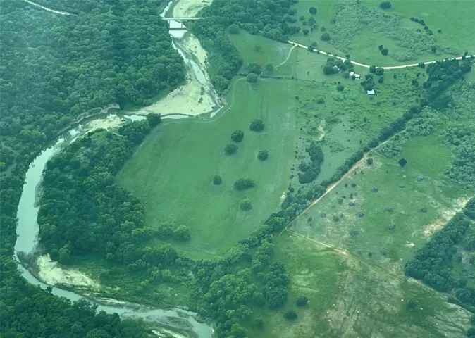
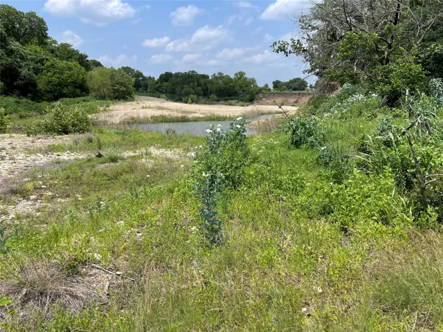
+"PublicRemarks": "Amazing 60 + or - acre tract located in Beautiful Bosque County. This Bosque River property will not disappoint with so much to offer. Beautiful park like setting. Perfect mix of wooded and open areas. Lush grasses. Wildlife paradise with abundant deer, turkey, hogs. Excellent country neighborhood offers the beauty and tranquility Bosque County is known for. Don't miss out on your chance to own a sought after river front property. Perfect mix of wooded area and open pasture. Sandy loam soil great for crops, hay production and improved grasses. River on two sides of the property! Hay Barn. Survey required. 72 Miles to Fort Worth, 78 Miles to Dallas, 119 Miles to Austin."
+"AttributionContact": "254-226-5263"
+"CLIP": 6285501729
+"Country": "US"
+"CountyOrParish": "Bosque"
+"CreationDate": "2025-04-01T12:48:12.231308+00:00"
+"CumulativeDaysOnMarket": 111
+"CurrentUse": "Agricultural, Hunting, Ranch, Recreational"
+"Directions": "Take Hwy 6 N from Meridian, right on CR 2365, right on CR 2370, left on CR 2371, 1.3 miles and property is on the right."
+"DocumentsAvailable": "Aerial"
+"ElementarySchool": "Walnut Sp"
+"ElementarySchoolDistrict": "Walnut Springs ISD"
+"Fencing": "Barbed Wire"
+"HighSchool": "Walnut Sp"
+"HighSchoolDistrict": "Walnut Springs ISD"
+"HumanModifiedYN": true
+"RFTransactionType": "For Sale"
+"InternetAutomatedValuationDisplayYN": true
+"InternetConsumerCommentYN": true
+"InternetEntireListingDisplayYN": true
+"ListAgentAOR": "Stephenville Association Of Realtors"
+"ListAgentDirectPhone": "254-226-5263"
+"ListAgentEmail": "jeaniecosper@gmail.com"
+"ListAgentFirstName": "Jeanie"
+"ListAgentKey": "20459497"
+"ListAgentKeyNumeric": "20459497"
+"ListAgentLastName": "Cosper"
+"ListAgentMiddleName": "M"
+"ListOfficeKey": "4503960"
+"ListOfficeKeyNumeric": "4503960"
+"ListOfficePhone": "254-226-5263"
+"ListingAgreement": "Exclusive Right To Sell"
+"ListingContractDate": "2025-04-01"
+"ListingKeyNumeric": 1109536987
+"ListingTerms": "Cash,Conventional,1031 Exchange"
+"LockBoxType": "None"
+"LotFeatures": "Acreage, Agricultural"
+"LotSizeAcres": 60.0
+"LotSizeSource": "Owner"
+"LotSizeSquareFeet": 2613600.0
+"MajorChangeTimestamp": "2025-07-21T23:09:18Z"
+"MiddleOrJuniorSchool": "Walnut Sp"
+"MlsStatus": "Active"
+"OriginalListPrice": 875000.0
+"OriginatingSystemKey": "453248053"
+"OwnerName": "Travis"
+"ParcelNumber": "36013"
+"PhotosChangeTimestamp": "2025-06-24T03:44:30Z"
+"PhotosCount": 32
+"Possession": "Close Of Escrow"
+"PossibleUse": "Agricultural, Cattle"
+"PriceChangeTimestamp": "2025-07-21T23:09:18Z"
+"RoadFrontageType": "County Road"
+"RoadSurfaceType": "Gravel"
+"ShowingAttendedYN": true
+"ShowingContactPhone": "2542265263"
+"ShowingContactType": "Agent"
+"ShowingRequirements": "Appointment Only"
+"SpecialListingConditions": "Standard"
+"StateOrProvince": "TX"
+"StatusChangeTimestamp": "2025-04-01T07:39:17Z"
+"StreetName": "CR 2371"
+"StreetNumber": "TBD"
+"SubdivisionName": "None"
+"SyndicateTo": "Homes.com,IDX Sites,Realtor.com,RPR,Syndication Allowed"
+"Utilities": "Electricity Available,None"
+"Vegetation": "Brush,Grassed,Partially Wooded"
+"VirtualTourURLUnbranded": "https://www.propertypanorama.com/instaview/ntreis/20888138"
+"WaterfrontFeatures": "River Front"
+"WaterfrontYN": true
+"ZoningDescription": "Agriculture"
+"Restrictions": "No Restrictions"
+"GarageDimensions": ",,"
+"TitleCompanyPhone": "2544352973"
+"TitleCompanyAddress": "Meridian, Tx"
+"TitleCompanyPreferred": "Bosque Cen-Tex"
+"OriginatingSystemSubName": "NTR_NTREIS"
+"@odata.id": "https://api.realtyfeed.com/reso/odata/Property('1109536987')"
+"provider_name": "NTREIS"
+"RecordSignature": 1087454950
+"UniversalParcelId": "urn:reso:upi:2.0:US:48035:36013"
+"CountrySubdivision": "48035"
+"Media": array:32 [
0 => array:57 [ …57]
1 => array:57 [ …57]
2 => array:57 [ …57]
3 => array:57 [ …57]
4 => array:57 [ …57]
5 => array:57 [ …57]
6 => array:57 [ …57]
7 => array:57 [ …57]
8 => array:57 [ …57]
9 => array:57 [ …57]
10 => array:57 [ …57]
11 => array:57 [ …57]
12 => array:57 [ …57]
13 => array:57 [ …57]
14 => array:57 [ …57]
15 => array:57 [ …57]
16 => array:57 [ …57]
17 => array:57 [ …57]
18 => array:57 [ …57]
19 => array:57 [ …57]
20 => array:57 [ …57]
21 => array:57 [ …57]
22 => array:57 [ …57]
23 => array:57 [ …57]
24 => array:57 [ …57]
25 => array:57 [ …57]
26 => array:57 [ …57]
27 => array:57 [ …57]
28 => array:57 [ …57]
29 => array:57 [ …57]
30 => array:57 [ …57]
31 => array:57 [ …57]
]
+"ID": "42538"
}
6 => Realtyna\MlsOnTheFly\Components\CloudPost\SubComponents\RFClient\SDK\RF\Entities\RFProperty {#4744
+post_id: "121277"
+post_author: 1
+"ListingKey": "1119106225"
+"ListingId": "20998588"
+"PropertyType": "Land"
+"PropertySubType": "Unimproved Land"
+"StandardStatus": "Active"
+"ModificationTimestamp": "2025-07-22T06:10:45Z"
+"RFModificationTimestamp": "2025-07-22T06:21:53Z"
+"ListPrice": 100000.0
+"BathroomsTotalInteger": 0
+"BathroomsHalf": 0
+"BedroomsTotal": 0
+"LotSizeArea": 2.303
+"LivingArea": 0
+"BuildingAreaTotal": 0
+"City": "Joshua"
+"PostalCode": "76058"
+"UnparsedAddress": "Tract 2 Joshua Ryan Drive, Joshua, Texas 76058"
+"Coordinates": array:2 [
0 => -97.38991194
1 => 32.44936283
]
+"Latitude": 32.44936283
+"Longitude": -97.38991194
+"YearBuilt": 0
+"InternetAddressDisplayYN": true
+"FeedTypes": "IDX"
+"ListAgentFullName": "Amy Rumfield"
+"ListOfficeName": "All City Real Estate, Ltd. Co."
+"ListAgentMlsId": "0749602"
+"ListOfficeMlsId": "ALLC01"
+"OriginatingSystemName": "NTR"
+"PublicRemarks": "Hard to Find Treed Acreage in Joshua ISD –Tract 2-2.303 acres Don’t miss this rare opportunity to own beautiful, tree studded acreage in the highly sought after Joshua Independent School District! Nestled in a quiet rural area just minutes from town, this picturesque property offers both privacy and convenience in a serene, natural setting. Scattered mature trees provide shade, character, and the perfect backdrop for your dream home, barndominium, or weekend getaway. Whether you're looking to build, invest, or create your own private retreat, the possibilities are endless. Water and sewer is available through Johnson County Special Utility District, or you can install your own well and septic. Acreage like this complete with trees and located in Joshua ISD is hard to find."
+"AttributionContact": "866-277-6005"
+"Country": "US"
+"CountyOrParish": "Johnson"
+"CreationDate": "2025-07-12T12:36:36.673451+00:00"
+"CumulativeDaysOnMarket": 10
+"Directions": "From Burleson on SH 174 go 6 miles and turn right on E. 14Th St. Turn left on Eddy Ave. Turn left on Ranchette Dr. Turn left on SW 24th St. Joshua Ryan Dr. will be on your left. Signs marking each tract."
+"ElementarySchool": "Staples"
+"ElementarySchoolDistrict": "Joshua ISD"
+"HighSchool": "Joshua"
+"HighSchoolDistrict": "Joshua ISD"
+"RFTransactionType": "For Sale"
+"InternetAutomatedValuationDisplayYN": true
+"InternetConsumerCommentYN": true
+"InternetEntireListingDisplayYN": true
+"ListAgentAOR": "Metrotex Association of Realtors Inc"
+"ListAgentDirectPhone": "817-313-0485"
+"ListAgentEmail": "dusty@rumfields.com"
+"ListAgentFirstName": "Amy"
+"ListAgentKey": "20444637"
+"ListAgentKeyNumeric": "20444637"
+"ListAgentLastName": "Rumfield"
+"ListAgentMiddleName": "B"
+"ListOfficeKey": "4511807"
+"ListOfficeKeyNumeric": "4511807"
+"ListOfficePhone": "866-277-6005"
+"ListingAgreement": "Exclusive Right To Sell"
+"ListingContractDate": "2025-07-12"
+"ListingKeyNumeric": 1119106225
+"LockBoxType": "None"
+"LotFeatures": "Acreage,City Lot"
+"LotSizeAcres": 2.303
+"LotSizeSquareFeet": 100318.68
+"MajorChangeTimestamp": "2025-07-12T07:35:17Z"
+"MiddleOrJuniorSchool": "Loflin"
+"MlsStatus": "Active"
+"OriginalListPrice": 100000.0
+"OriginatingSystemKey": "459194502"
+"OwnerName": "Rumfield Properties, Inc."
+"ParcelNumber": "126017303496"
+"PhotosChangeTimestamp": "2025-07-21T19:12:30Z"
+"PhotosCount": 10
+"Possession": "Close Of Escrow"
+"PriceChangeTimestamp": "2025-07-12T07:35:17Z"
+"PrivateRemarks": "Listing agent related to seller. Buyers agent to verify all information in listing."
+"ShowingInstructions": "Go and show"
+"SpecialListingConditions": "Standard"
+"StateOrProvince": "TX"
+"StatusChangeTimestamp": "2025-07-12T07:35:17Z"
+"StreetName": "Joshua Ryan"
+"StreetNumber": "Tract 2"
+"StreetSuffix": "Drive"
+"SubdivisionName": "G Casseland"
+"SyndicateTo": "Homes.com,IDX Sites,Realtor.com,RPR,Syndication Allowed"
+"TaxAnnualAmount": "26.0"
+"TaxBlock": "ABST 173"
+"TaxLegalDescription": "ABST 173 TR 2 G CASSELAND-2.303 acres"
+"TaxLot": "2"
+"Utilities": "Other"
+"VirtualTourURLUnbranded": "https://www.propertypanorama.com/instaview/ntreis/20998588"
+"ZoningDescription": "Residential"
+"Restrictions": "Other Restrictions"
+"HumanModifiedYN": false
+"GarageDimensions": ",,"
+"OriginatingSystemSubName": "NTR_NTREIS"
+"@odata.id": "https://api.realtyfeed.com/reso/odata/Property('1119106225')"
+"provider_name": "NTREIS"
+"RecordSignature": -1193903972
+"UniversalParcelId": "urn:reso:upi:2.0:US:48251:126017303496"
+"CountrySubdivision": "48251"
+"Media": array:10 [
0 => array:57 [ …57]
1 => array:57 [ …57]
2 => array:57 [ …57]
3 => array:57 [ …57]
4 => array:57 [ …57]
5 => array:57 [ …57]
6 => array:57 [ …57]
7 => array:57 [ …57]
8 => array:57 [ …57]
9 => array:57 [ …57]
]
+"ID": "121277"
}
7 => Realtyna\MlsOnTheFly\Components\CloudPost\SubComponents\RFClient\SDK\RF\Entities\RFProperty {#4687
+post_id: "153922"
+post_author: 1
+"ListingKey": "1118768640"
+"ListingId": "20988470"
+"PropertyType": "Land"
+"PropertySubType": "Unimproved Land"
+"StandardStatus": "Active"
+"ModificationTimestamp": "2025-07-21T20:21:54Z"
+"RFModificationTimestamp": "2025-07-21T21:05:41Z"
+"ListPrice": 360000.0
+"BathroomsTotalInteger": 0
+"BathroomsHalf": 0
+"BedroomsTotal": 0
+"LotSizeArea": 4.4628
+"LivingArea": 0
+"BuildingAreaTotal": 0
+"City": "Weatherford"
+"PostalCode": "76087"
+"UnparsedAddress": "Tbd Old Brock Road, Weatherford, Texas 76087"
+"Coordinates": array:2 [
0 => -97.85045
1 => 32.720387
]
+"Latitude": 32.720387
+"Longitude": -97.85045
+"YearBuilt": 0
+"InternetAddressDisplayYN": true
+"FeedTypes": "IDX"
+"ListAgentFullName": "Patti Hale"
+"ListOfficeName": "Mitchell Real Estate & Mgt, LL"
+"ListAgentMlsId": "0655900"
+"ListOfficeMlsId": "MITC01WF"
+"OriginatingSystemName": "NTR"
+"PublicRemarks": "Hard To Find! 4+ Acres of UNRESTRICTED Land in Brock ISD! No HOA! This is the Perfect Location for Anyone Wanting a Small Tract Outside of a Large Subdivision. Enjoy Quiet Living with Room for a Few Animals. This Property is Outside of the City Limits & Only Minutes from Highly Acclaimed Brock Schools, I-20 for Easy Commuting & the Brazos River. Come to the Country and Build Your New Home Today!"
+"AttributionContact": "(817) 550-6610"
+"CLIP": 3729153277
+"CoListAgentDirectPhone": "(817) 613-6945"
+"CoListAgentEmail": "paulamitchell2010@yahoo.com"
+"CoListAgentFirstName": "Paula"
+"CoListAgentFullName": "Paula Mitchell"
+"CoListAgentKey": "20435471"
+"CoListAgentKeyNumeric": "20435471"
+"CoListAgentLastName": "Mitchell"
+"CoListAgentMlsId": "0470220"
+"CoListAgentMobilePhone": "(817) 613-6945"
+"CoListOfficeKey": "4496734"
+"CoListOfficeKeyNumeric": "4496734"
+"CoListOfficeMlsId": "MITC01WF"
+"CoListOfficeName": "Mitchell Real Estate & Mgt, LL"
+"CoListOfficePhone": "(817) 550-6610"
+"Country": "US"
+"CountyOrParish": "Parker"
+"CreationDate": "2025-07-04T03:16:35.888027+00:00"
+"CumulativeDaysOnMarket": 19
+"Directions": "From Weatherford. Take I-20 West. Take Exit 403 Dennis Rd. Go South of Dennis Rd. Turn Right onto Old Brock Rd. Property is on the Right."
+"DocumentsAvailable": "Survey"
+"ElementarySchool": "Brock"
+"ElementarySchoolDistrict": "Brock ISD"
+"HighSchool": "Brock"
+"HighSchoolDistrict": "Brock ISD"
+"HumanModifiedYN": true
+"RFTransactionType": "For Sale"
+"InternetAutomatedValuationDisplayYN": true
+"InternetConsumerCommentYN": true
+"InternetEntireListingDisplayYN": true
+"ListAgentAOR": "Greater Metro West Association Realtors Inc"
+"ListAgentDirectPhone": "(817) 694-7201"
+"ListAgentEmail": "pattihale@msn.com"
+"ListAgentFirstName": "Patti"
+"ListAgentKey": "20435019"
+"ListAgentKeyNumeric": "20435019"
+"ListAgentLastName": "Hale"
+"ListAgentMiddleName": "Ann"
+"ListOfficeKey": "4496734"
+"ListOfficeKeyNumeric": "4496734"
+"ListOfficePhone": "(817) 550-6610"
+"ListingAgreement": "Exclusive Right To Sell"
+"ListingContractDate": "2025-07-02"
+"ListingKeyNumeric": 1118768640
+"LockBoxType": "None"
+"LotFeatures": "Acreage"
+"LotSizeAcres": 4.4628
+"LotSizeSquareFeet": 194399.57
+"MajorChangeTimestamp": "2025-07-03T19:08:27Z"
+"MiddleOrJuniorSchool": "Brock"
+"MlsStatus": "Active"
+"OriginalListPrice": 360000.0
+"OriginatingSystemKey": "457624396"
+"OwnerName": "Benton"
+"ParcelNumber": "9999"
+"PhotosChangeTimestamp": "2025-07-21T20:22:31Z"
+"PhotosCount": 10
+"Possession": "Close Of Escrow"
+"PrivateRemarks": """
This property is TRACT FOUR - 4.4628 Acres - on the uploaded survey with 272.96' of road frontage on Old Brock Rd. \r\n
\r\n
All information in this advertisement & herein is considered reliable but not guaranteed. Buyer to verify all information in MLS, marketing or website including but not limited to schools, square footage, acres, taxes, easements & minerals.
"""
+"RoadFrontageType": "County Road"
+"RoadSurfaceType": "Asphalt"
+"ShowingContactPhone": "817-694-7201"
+"ShowingContactType": "Agent"
+"ShowingInstructions": "Text or Email Agent."
+"ShowingRequirements": "See Remarks"
+"SpecialListingConditions": "Standard"
+"StateOrProvince": "TX"
+"StatusChangeTimestamp": "2025-07-03T19:08:27Z"
+"StreetName": "Old Brock"
+"StreetNumber": "TBD"
+"StreetSuffix": "Road"
+"SubdivisionName": "None"
+"SyndicateTo": "Homes.com,IDX Sites,Realtor.com,RPR,Syndication Allowed"
+"Utilities": "None"
+"VirtualTourURLUnbranded": "https://www.propertypanorama.com/instaview/ntreis/20988470"
+"ZoningDescription": "None"
+"Restrictions": "No Restrictions"
+"GarageDimensions": ",,"
+"TitleCompanyPhone": "817-341-0700"
+"TitleCompanyAddress": "Weatherford"
+"TitleCompanyPreferred": "Providence Title-Slimp"
+"OriginatingSystemSubName": "NTR_NTREIS"
+"@odata.id": "https://api.realtyfeed.com/reso/odata/Property('1118768640')"
+"provider_name": "NTREIS"
+"RecordSignature": 626518241
+"UniversalParcelId": "urn:reso:upi:2.0:US:48367:9999"
+"CountrySubdivision": "48367"
+"Media": array:10 [
0 => array:57 [ …57]
1 => array:57 [ …57]
2 => array:57 [ …57]
3 => array:57 [ …57]
4 => array:57 [ …57]
5 => array:57 [ …57]
6 => array:57 [ …57]
7 => array:57 [ …57]
8 => array:57 [ …57]
9 => array:57 [ …57]
]
+"ID": "153922"
}
8 => Realtyna\MlsOnTheFly\Components\CloudPost\SubComponents\RFClient\SDK\RF\Entities\RFProperty {#4686
+post_id: "96920"
+post_author: 1
+"ListingKey": "1103659032"
+"ListingId": "20831340"
+"PropertyType": "Land"
+"PropertySubType": "Unimproved Land"
+"StandardStatus": "Active"
+"ModificationTimestamp": "2025-07-21T20:47:44Z"
+"RFModificationTimestamp": "2025-07-21T22:53:41Z"
+"ListPrice": 315000.0
+"BathroomsTotalInteger": 0
+"BathroomsHalf": 0
+"BedroomsTotal": 0
+"LotSizeArea": 10.185
+"LivingArea": 0
+"BuildingAreaTotal": 0
+"City": "Eustace"
+"PostalCode": "75124"
+"UnparsedAddress": "0 Charlotte, Eustace, Texas 75124"
+"Coordinates": array:2 [
0 => -96.019651
1 => 32.249057
]
+"Latitude": 32.249057
+"Longitude": -96.019651
+"YearBuilt": 0
+"InternetAddressDisplayYN": true
+"FeedTypes": "IDX"
+"ListAgentFullName": "Amy Farris"
+"ListOfficeName": "Allie Beth Allman & Assoc."
+"ListAgentMlsId": "0681839"
+"ListOfficeMlsId": "ABAR01"
+"OriginatingSystemName": "NTR"
+"PublicRemarks": "Nestled away from the water's edge of Cedar Creek Lake, this unique 10 acre property backs up to the end of a channel, which gracefully transforms into a meandering creek that winds through the very heart of this expansive property. Plotted for 17 lots and sitting with 900 feet of road frontage, it is ready for a charming residential community or perhaps an exclusive enclave of custom-built homes, RV park or even a tiny home community, each with their own unique slice of paradise. Whether you're considering a serene personal retreat, a real estate investment, or a community development project, this 10-acre gem at Cedar Creek Lake is the canvas of your dreams."
+"AttributionContact": "469-236-1533"
+"CLIP": 2718838007
+"CoListAgentDirectPhone": "214-697-4019"
+"CoListAgentEmail": "holly.davis@alliebeth.com"
+"CoListAgentFirstName": "Holly"
+"CoListAgentFullName": "Holly Davis"
+"CoListAgentKey": "20469332"
+"CoListAgentKeyNumeric": "20469332"
+"CoListAgentLastName": "Davis"
+"CoListAgentMiddleName": "H"
+"CoListAgentMlsId": "0704209"
+"CoListOfficeKey": "4511595"
+"CoListOfficeKeyNumeric": "4511595"
+"CoListOfficeMlsId": "ABAR01"
+"CoListOfficeName": "Allie Beth Allman & Assoc."
+"CoListOfficePhone": "214-521-7355"
+"Country": "US"
+"CountyOrParish": "Henderson"
+"CreationDate": "2025-01-30T21:24:02.853452+00:00"
+"CumulativeDaysOnMarket": 172
+"CurrentUse": "Unimproved, Vacant"
+"DevelopmentStatus": "Other"
+"Directions": "From Dallas take 175 East towards Eustace. Take a Right on FM 316. Left on CR 2813. Turn Right on Charlotte Trail. Property will be on your left."
+"ElementarySchool": "Eustace"
+"ElementarySchoolDistrict": "Eustace ISD"
+"HighSchool": "Eustace"
+"HighSchoolDistrict": "Eustace ISD"
+"HumanModifiedYN": true
+"RFTransactionType": "For Sale"
+"InternetAutomatedValuationDisplayYN": true
+"InternetEntireListingDisplayYN": true
+"ListAgentAOR": "Metrotex Association of Realtors Inc"
+"ListAgentDirectPhone": "469-236-1533"
+"ListAgentEmail": "amy.farris@alliebeth.com"
+"ListAgentFirstName": "Amy"
+"ListAgentKey": "20466772"
+"ListAgentKeyNumeric": "20466772"
+"ListAgentLastName": "Farris"
+"ListAgentMiddleName": "R"
+"ListOfficeKey": "4511595"
+"ListOfficeKeyNumeric": "4511595"
+"ListOfficePhone": "214-521-7355"
+"ListingAgreement": "Exclusive Right To Sell"
+"ListingContractDate": "2025-01-30"
+"ListingKeyNumeric": 1103659032
+"LockBoxType": "None"
+"LotFeatures": "Acreage"
+"LotSizeAcres": 10.185
+"LotSizeSquareFeet": 443658.6
+"MajorChangeTimestamp": "2025-07-21T15:47:14Z"
+"MiddleOrJuniorSchool": "Eustace"
+"MlsStatus": "Active"
+"OriginalListPrice": 350000.0
+"OriginatingSystemKey": "448969939"
+"OwnerName": "Individual"
+"ParcelNumber": "R000005445"
+"PhotosChangeTimestamp": "2025-04-23T14:08:30Z"
+"PhotosCount": 5
+"Possession": "Close Of Escrow"
+"PriceChangeTimestamp": "2025-07-21T15:47:14Z"
+"PrivateRemarks": "Information provided is deemed reliable, but is not guaranteed & should be independently verified. Buyer or Buyer's Agent to verify measurements, schools, & tax, etc."
+"ShowingContactPhone": "(800) 257-1242"
+"ShowingContactType": "Showing Service"
+"ShowingInstructions": "Schedule through Broker Bay or call agent"
+"ShowingRequirements": "Call Before Showing"
+"SpecialListingConditions": "Standard"
+"StateOrProvince": "TX"
+"StatusChangeTimestamp": "2025-01-30T14:42:08Z"
+"StreetName": "Charlotte"
+"StreetNumber": "0"
+"SubdivisionName": "na"
+"SyndicateTo": "Homes.com,IDX Sites,Realtor.com,RPR,Syndication Allowed"
+"Utilities": "None"
+"VirtualTourURLUnbranded": "https://www.propertypanorama.com/instaview/ntreis/20831340"
+"ZoningDescription": "Residential"
+"Restrictions": "No Restrictions"
+"GarageDimensions": ",,"
+"TitleCompanyPhone": "(214) 647-9748"
+"TitleCompanyAddress": "8343 Douglas #175, Dallas"
+"TitleCompanyPreferred": "Lawyers Title - Ramsey"
+"OriginatingSystemSubName": "NTR_NTREIS"
+"@odata.id": "https://api.realtyfeed.com/reso/odata/Property('1103659032')"
+"provider_name": "NTREIS"
+"RecordSignature": -1030960521
+"UniversalParcelId": "urn:reso:upi:2.0:US:48213:R000005445"
+"CountrySubdivision": "48213"
+"Media": array:5 [
0 => array:57 [ …57]
1 => array:57 [ …57]
2 => array:58 [ …58]
3 => array:58 [ …58]
4 => array:58 [ …58]
]
+"ID": "96920"
}
9 => Realtyna\MlsOnTheFly\Components\CloudPost\SubComponents\RFClient\SDK\RF\Entities\RFProperty {#4685
+post_id: "151333"
+post_author: 1
+"ListingKey": "1119194632"
+"ListingId": "20998951"
+"PropertyType": "Land"
+"PropertySubType": "Unimproved Land"
+"StandardStatus": "Pending"
+"ModificationTimestamp": "2025-07-21T20:10:52Z"
+"RFModificationTimestamp": "2025-07-21T22:59:49Z"
+"ListPrice": 29500.0
+"BathroomsTotalInteger": 0
+"BathroomsHalf": 0
+"BedroomsTotal": 0
+"LotSizeArea": 22.63
+"LivingArea": 0
+"BuildingAreaTotal": 0
+"City": "Shreveport"
+"PostalCode": "71061"
+"UnparsedAddress": "00 Belchard Oil City Road, Shreveport, Louisiana 71061"
+"Coordinates": array:2 [
0 => -93.96328451
1 => 32.76861224
]
+"Latitude": 32.76861224
+"Longitude": -93.96328451
+"YearBuilt": 0
+"InternetAddressDisplayYN": true
+"FeedTypes": "IDX"
+"ListAgentFullName": "Andy Osborn"
+"ListOfficeName": "Osborn Hays Real Estate, LLC"
+"ListAgentMlsId": "ANDO"
+"ListOfficeMlsId": "HAYS01NL"
+"OriginatingSystemName": "NTR"
+"PublicRemarks": "Here’s your shot at owning 22 acres of prime waterfowl habitat smack in the middle of the flyway. Nestled between Caddo Lake and the Red River, this beautiful cypress swamp features hardwood ridges, excellent roosting cover, and everything ducks (and duck hunters) love.A well-placed blind is already set up, complete with a float boom to help maintain open water—just bring your decoys and thermos. The property offers great opportunities for crawfish during the spring, and you’ll get a front-row seat to Louisiana’s wildlife all year long. Whether you’re looking for a personal hunting paradise, a unique recreational tract, or just want to get your boots muddy in something special—this one’s hard to beat. Don’t miss out. Seller does not own the minerals. Seller is licensed real estate agent in the State of Louisiana."
+"CoListAgentDirectPhone": "318-218-7418"
+"CoListAgentEmail": "emilyhaysrealtor@gmail.com"
+"CoListAgentFirstName": "Emily"
+"CoListAgentFullName": "Emily Hays"
+"CoListAgentKey": "20501420"
+"CoListAgentKeyNumeric": "20501420"
+"CoListAgentLastName": "Hays"
+"CoListAgentMlsId": "EMHA"
+"CoListAgentMobilePhone": "318-218-7418"
+"CoListOfficeKey": "5065163"
+"CoListOfficeKeyNumeric": "5065163"
+"CoListOfficeMlsId": "HAYS01NL"
+"CoListOfficeName": "Osborn Hays Real Estate, LLC"
+"CoListOfficePhone": "318-603-3641"
+"Country": "US"
+"CountyOrParish": "Caddo"
+"CreationDate": "2025-07-15T04:02:17.463094+00:00"
+"CumulativeDaysOnMarket": 7
+"CurrentUse": "Hunting, Investment, Recreational"
+"Directions": "Take I 49 North out of Shreveport and exit LA HWY 530 (Belchard Oil City Road) and head west. Property is located about 5 miles on the right. Pleas call for access instructions."
+"DocumentsAvailable": "Aerial"
+"ElementarySchoolDistrict": "Caddo PSB"
+"HighSchoolDistrict": "Caddo PSB"
+"HumanModifiedYN": true
+"RFTransactionType": "For Sale"
+"InternetAutomatedValuationDisplayYN": true
+"InternetConsumerCommentYN": true
+"InternetEntireListingDisplayYN": true
+"ListAgentAOR": "Northwest Louisiana Association of REALTORS"
+"ListAgentDirectPhone": "318-564-3701"
+"ListAgentEmail": "andy@andyosborn.com"
+"ListAgentFirstName": "Andy"
+"ListAgentKey": "20499796"
+"ListAgentKeyNumeric": "20499796"
+"ListAgentLastName": "Osborn"
+"ListOfficeKey": "5065163"
+"ListOfficeKeyNumeric": "5065163"
+"ListOfficePhone": "318-603-3641"
+"ListingAgreement": "Exclusive Right To Sell"
+"ListingContractDate": "2025-07-14"
+"ListingKeyNumeric": 1119194632
+"ListingTerms": "Cash"
+"LockBoxType": "None"
+"LotFeatures": "Acreage, Wooded, Wetlands, Waterfront"
+"LotSizeAcres": 22.63
+"LotSizeSource": "Assessor"
+"LotSizeSquareFeet": 985762.8
+"MajorChangeTimestamp": "2025-07-21T15:10:41Z"
+"MlsStatus": "Pending"
+"OffMarketDate": "2025-07-21"
+"OriginalListPrice": 29500.0
+"OriginatingSystemKey": "459213378"
+"OwnerName": "seller"
+"ParcelNumber": "211531-0-13"
+"PhotosChangeTimestamp": "2025-07-14T22:39:30Z"
+"PhotosCount": 3
+"Possession": "Close Of Escrow"
+"PossibleUse": "Hunting, Recreational"
+"PrivateRemarks": "Property is sold as is without warranities at closing."
+"PurchaseContractDate": "2025-07-21"
+"RoadFrontageType": "None"
+"ShowingContactPhone": "(800) 257-1242"
+"ShowingContactType": "Agent"
+"ShowingRequirements": "No Lockbox,No Sign"
+"SpecialListingConditions": "Standard"
+"StateOrProvince": "LA"
+"StatusChangeTimestamp": "2025-07-21T15:10:41Z"
+"StreetName": "Belchard Oil City"
+"StreetNumber": "00"
+"StreetSuffix": "Road"
+"SubdivisionName": "rural"
+"SyndicateTo": "Homes.com,IDX Sites,Realtor.com,RPR,Syndication Allowed"
+"TaxLegalDescription": "22.63 ACS - IN SW/4 OF NW/4 OF SEC 31-21-15"
+"Utilities": "None"
+"VirtualTourURLUnbranded": "https://www.propertypanorama.com/instaview/ntreis/20998951"
+"WaterfrontFeatures": "Lake Front,Waterfront"
+"WaterfrontYN": true
+"ZoningDescription": "AV"
+"Restrictions": "No Restrictions"
+"GarageDimensions": ",,"
+"OriginatingSystemSubName": "NTR_NTREIS"
+"@odata.id": "https://api.realtyfeed.com/reso/odata/Property('1119194632')"
+"provider_name": "NTREIS"
+"RecordSignature": -1764143913
+"UniversalParcelId": "urn:reso:upi:2.0:US:22017:211531-0-13"
+"CountrySubdivision": "22017"
+"Media": array:3 [
0 => array:57 [ …57]
1 => array:57 [ …57]
2 => array:57 [ …57]
]
+"ID": "151333"
}
10 => Realtyna\MlsOnTheFly\Components\CloudPost\SubComponents\RFClient\SDK\RF\Entities\RFProperty {#4684
+post_id: "33965"
+post_author: 1
+"ListingKey": "1107789621"
+"ListingId": "20854300"
+"PropertyType": "Land"
+"PropertySubType": "Unimproved Land"
+"StandardStatus": "Active"
+"ModificationTimestamp": "2025-07-21T21:04:41Z"
+"RFModificationTimestamp": "2025-07-21T22:34:08Z"
+"ListPrice": 295000.0
+"BathroomsTotalInteger": 0
+"BathroomsHalf": 0
+"BedroomsTotal": 0
+"LotSizeArea": 8.615
+"LivingArea": 0
+"BuildingAreaTotal": 0
+"City": "Tyler"
+"PostalCode": "75706"
+"UnparsedAddress": "449 E I-20, Tyler, Texas 75706"
+"Coordinates": array:2 [
0 => -95.28099192
1 => 32.45499865
]
+"Latitude": 32.45499865
+"Longitude": -95.28099192
+"YearBuilt": 0
+"InternetAddressDisplayYN": true
+"FeedTypes": "IDX"
+"ListAgentFullName": "Matthew Marshall"
+"ListOfficeName": "Drake Real Estate & Investment"
+"ListAgentMlsId": "0544812"
+"ListOfficeMlsId": "DRAK01"
+"OriginatingSystemName": "NTR"
+"PublicRemarks": """
Don't miss this opportunity for 8.61 unrestricted acres with I-20 visibility in a rapidly growing area! Positioned on the northeast side of I-20 & FM 14 State Park Highway. Prime for development or investment. Perfect for businesses looking for great exposure and easy access. Ideal for commercial, residential, industrial, warehousing, storage units, RV park, truck or car wash center, restaurant, and more. \r\n
\r\n
Key Features:\r\n
105.83 feet of I-20 frontage access. \r\n
38,000+ annual average daily traffic (TxDOT). \r\n
Unrestricted use. \r\n
Owner Financing Available. \r\n
Survey available.
"""
+"AttributionContact": "903-581-3737"
+"CLIP": 1048473066
+"Country": "US"
+"CountyOrParish": "Smith"
+"CreationDate": "2025-02-26T15:06:21.815031+00:00"
+"CumulativeDaysOnMarket": 145
+"CurrentUse": "Recreational, Timber"
+"Directions": "From Tyler, head north on FM 14. Land will be on the right, just after passing under I-20."
+"ElementarySchool": "Winona"
+"ElementarySchoolDistrict": "Winona ISD"
+"HighSchool": "Winona"
+"HighSchoolDistrict": "Winona ISD"
+"HumanModifiedYN": true
+"RFTransactionType": "For Sale"
+"InternetAutomatedValuationDisplayYN": true
+"InternetEntireListingDisplayYN": true
+"ListAgentAOR": "Metrotex Association of Realtors Inc"
+"ListAgentDirectPhone": "903-581-3737"
+"ListAgentEmail": "land@draketexas.com"
+"ListAgentFirstName": "Matthew"
+"ListAgentKey": "20470594"
+"ListAgentKeyNumeric": "20470594"
+"ListAgentLastName": "Marshall"
+"ListOfficeKey": "4510863"
+"ListOfficeKeyNumeric": "4510863"
+"ListOfficePhone": "903-581-3737"
+"ListingAgreement": "Exclusive Right To Sell"
+"ListingContractDate": "2025-02-26"
+"ListingKeyNumeric": 1107789621
+"ListingTerms": "Cash,Conventional,FHA,Owner Will Carry,Other"
+"LockBoxType": "None"
+"LotFeatures": "Acreage,Many Trees"
+"LotSizeAcres": 8.615
+"LotSizeDimensions": "313x1196"
+"LotSizeSquareFeet": 375269.4
+"MajorChangeTimestamp": "2025-07-21T16:04:03Z"
+"MiddleOrJuniorSchool": "Winona"
+"MlsStatus": "Active"
+"OriginalListPrice": 359930.0
+"OriginatingSystemKey": "449974346"
+"OwnerName": "Roberts"
+"ParcelNumber": "117797"
+"PhotosChangeTimestamp": "2025-02-26T15:02:30Z"
+"PhotosCount": 4
+"Possession": "Close Of Escrow"
+"PossibleUse": "Commercial,Development,Industrial,Mini Storage,Mixed Use,Residential,Recreational,Retail,See Remarks,Timber,Warehouse"
+"PriceChangeTimestamp": "2025-07-21T16:04:03Z"
+"PrivateRemarks": "Owner Financing is available with 100k down, 5-7 year note, 10% interest"
+"RoadFrontageType": "Interstate"
+"ShowingContactPhone": "903.630.0582"
+"ShowingContactType": "Agent"
+"ShowingInstructions": "Text Listing Agent"
+"SpecialListingConditions": "Standard"
+"StateOrProvince": "TX"
+"StatusChangeTimestamp": "2025-02-26T08:57:11Z"
+"StreetDirPrefix": "E"
+"StreetName": "I-20"
+"StreetNumber": "449"
+"StreetNumberNumeric": "449"
+"SubdivisionName": "A100006 - A0006 E DEBARD"
+"SyndicateTo": "Homes.com,IDX Sites,Realtor.com,RPR,Syndication Allowed"
+"Utilities": "Other"
+"Vegetation": "Wooded"
+"VirtualTourURLUnbranded": "https://www.propertypanorama.com/instaview/ntreis/20854300"
+"ZoningDescription": "N/A"
+"Restrictions": "No Restrictions"
+"GarageDimensions": ",,"
+"OriginatingSystemSubName": "NTR_NTREIS"
+"@odata.id": "https://api.realtyfeed.com/reso/odata/Property('1107789621')"
+"provider_name": "NTREIS"
+"RecordSignature": -1234920365
+"UniversalParcelId": "urn:reso:upi:2.0:US:48423:117797"
+"CountrySubdivision": "48423"
+"Media": array:4 [
0 => array:58 [ …58]
1 => array:58 [ …58]
2 => array:58 [ …58]
3 => array:58 [ …58]
]
+"ID": "33965"
}
11 => Realtyna\MlsOnTheFly\Components\CloudPost\SubComponents\RFClient\SDK\RF\Entities\RFProperty {#4683
+post_id: "29846"
+post_author: 1
+"ListingKey": "1088848011"
+"ListingId": "20738035"
+"PropertyType": "Land"
+"PropertySubType": "Unimproved Land"
+"StandardStatus": "Active Under Contract"
+"ModificationTimestamp": "2025-07-21T20:58:21Z"
+"RFModificationTimestamp": "2025-07-21T22:41:14Z"
+"ListPrice": 315000.0
+"BathroomsTotalInteger": 0
+"BathroomsHalf": 0
+"BedroomsTotal": 0
+"LotSizeArea": 15.84
+"LivingArea": 0
+"BuildingAreaTotal": 0
+"City": "Whitney"
+"PostalCode": "76692"
+"UnparsedAddress": "452 Hcr 1227, Whitney, Texas 76692"
+"Coordinates": array:2 [
0 => -97.324507
1 => 32.004694
]
+"Latitude": 32.004694
+"Longitude": -97.324507
+"YearBuilt": 0
+"InternetAddressDisplayYN": true
+"FeedTypes": "IDX"
+"ListAgentFullName": "Tara Roden"
+"ListOfficeName": "Fathom Realty LLC"
+"ListAgentMlsId": "0516573"
+"ListOfficeMlsId": "FATHJC01"
+"OriginatingSystemName": "NTR"
+"PublicRemarks": "Looking to move to the country and build your dream home ? This is the one you have been waiting for . 15.84 pretty acres in Whitney isd with a 1 half acre pond that has already had alot of improvements made to the property. There is a 35x45 metal building with water and electric plus the owners have already installed a driveway , perimeter fence, and 2 cross fences . Call today to schedule an appointment to see this great property ."
+"AttributionContact": "(877) 661-1977"
+"CLIP": 5248087080
+"CoListAgentEmail": "rickyroden33@gmail.com"
+"CoListAgentFirstName": "Ricky"
+"CoListAgentFullName": "Ricky Roden"
+"CoListAgentKey": "20438533"
+"CoListAgentKeyNumeric": "20438533"
+"CoListAgentLastName": "Roden"
+"CoListAgentMiddleName": "D"
+"CoListAgentMlsId": "0669593"
+"CoListAgentMobilePhone": "817-202-7458"
+"CoListOfficeKey": "4520178"
+"CoListOfficeKeyNumeric": "4520178"
+"CoListOfficeMlsId": "FATHJC01"
+"CoListOfficeName": "Fathom Realty LLC"
+"CoListOfficePhone": "(877) 661-1977"
+"Country": "US"
+"CountyOrParish": "Hill"
+"CreationDate": "2024-09-27T09:34:18.421647+00:00"
+"CumulativeDaysOnMarket": 300
+"DevelopmentStatus": "Other"
+"Directions": "gps"
+"ElementarySchool": "Whitney"
+"ElementarySchoolDistrict": "Whitney ISD"
+"Exclusions": "dutch elm ranch sign, minerals"
+"HighSchool": "Whitney"
+"HighSchoolDistrict": "Whitney ISD"
+"HumanModifiedYN": true
+"RFTransactionType": "For Sale"
+"InternetAutomatedValuationDisplayYN": true
+"InternetConsumerCommentYN": true
+"InternetEntireListingDisplayYN": true
+"ListAgentAOR": "Johnson County Association Of Realtors"
+"ListAgentDirectPhone": "(817) 202-7459"
+"ListAgentEmail": "tararoden33@gmail.com"
+"ListAgentFirstName": "Tara"
+"ListAgentKey": "20478941"
+"ListAgentKeyNumeric": "20478941"
+"ListAgentLastName": "Roden"
+"ListOfficeKey": "4520178"
+"ListOfficeKeyNumeric": "4520178"
+"ListOfficePhone": "(877) 661-1977"
+"ListingAgreement": "Exclusive Right To Sell"
+"ListingContractDate": "2024-09-24"
+"ListingKeyNumeric": 1088848011
+"LockBoxType": "Combo"
+"LotFeatures": "Acreage,Pond on Lot"
+"LotSizeAcres": 15.84
+"LotSizeSquareFeet": 689990.4
+"MajorChangeTimestamp": "2025-07-21T15:58:09Z"
+"MiddleOrJuniorSchool": "Whitney"
+"MlsStatus": "Active Under Contract"
+"OriginalListPrice": 315000.0
+"OriginatingSystemKey": "444833708"
+"OwnerName": "of record"
+"ParcelNumber": "106272"
+"PhotosChangeTimestamp": "2025-04-08T17:12:30Z"
+"PhotosCount": 35
+"Possession": "Close Of Escrow"
+"PostalCodePlus4": "4767"
+"PrivateRemarks": "Information Deemed Reliable But Not Guaranteed"
+"PurchaseContractDate": "2025-07-19"
+"SpecialListingConditions": "Standard"
+"StateOrProvince": "TX"
+"StatusChangeTimestamp": "2025-07-21T15:58:09Z"
+"StreetName": "Hcr 1227"
+"StreetNumber": "452"
+"StreetNumberNumeric": "452"
+"SubdivisionName": "0"
+"SyndicateTo": "Homes.com,IDX Sites,Realtor.com,RPR,Syndication Allowed"
+"TaxAnnualAmount": "26.0"
+"TaxLegalDescription": "R COLLEGE A-754 TR 22B LT 4 15.84 AC"
+"TaxLot": "4"
+"Utilities": "Electricity Available,Water Available"
+"VirtualTourURLUnbranded": "https://www.propertypanorama.com/instaview/ntreis/20738035"
+"ZoningDescription": "0"
+"Restrictions": "Deed Restrictions"
+"GarageDimensions": ",,"
+"OriginatingSystemSubName": "NTR_NTREIS"
+"@odata.id": "https://api.realtyfeed.com/reso/odata/Property('1088848011')"
+"provider_name": "NTREIS"
+"RecordSignature": -663990431
+"UniversalParcelId": "urn:reso:upi:2.0:US:48217:106272"
+"CountrySubdivision": "48217"
+"Media": array:35 [
0 => array:57 [ …57]
1 => array:58 [ …58]
2 => array:58 [ …58]
3 => array:58 [ …58]
4 => array:58 [ …58]
5 => array:58 [ …58]
6 => array:58 [ …58]
7 => array:58 [ …58]
8 => array:58 [ …58]
9 => array:58 [ …58]
10 => array:58 [ …58]
11 => array:58 [ …58]
12 => array:58 [ …58]
13 => array:58 [ …58]
14 => array:58 [ …58]
15 => array:58 [ …58]
16 => array:58 [ …58]
17 => array:58 [ …58]
18 => array:58 [ …58]
19 => array:58 [ …58]
20 => array:58 [ …58]
21 => array:58 [ …58]
22 => array:58 [ …58]
23 => array:58 [ …58]
24 => array:58 [ …58]
25 => array:58 [ …58]
26 => array:58 [ …58]
27 => array:58 [ …58]
28 => array:58 [ …58]
29 => array:58 [ …58]
30 => array:58 [ …58]
31 => array:58 [ …58]
32 => array:58 [ …58]
33 => array:58 [ …58]
34 => array:58 [ …58]
]
+"ID": "29846"
}
]
+success: true
+page_size: 12
+page_count: 7453
+count: 89433
+after_key: ""
}
"RF Response Time" => "0.25 seconds"
]
]