array:1 [
"RF Query: /Property?$select=ALL&$orderby=LivingArea DESC&$top=12&$skip=88908&$filter=(StandardStatus in ('Active','Pending','Active Under Contract','Coming Soon') and PropertyType in ('Residential','Land'))/Property?$select=ALL&$orderby=LivingArea DESC&$top=12&$skip=88908&$filter=(StandardStatus in ('Active','Pending','Active Under Contract','Coming Soon') and PropertyType in ('Residential','Land'))&$expand=Media/Property?$select=ALL&$orderby=LivingArea DESC&$top=12&$skip=88908&$filter=(StandardStatus in ('Active','Pending','Active Under Contract','Coming Soon') and PropertyType in ('Residential','Land'))/Property?$select=ALL&$orderby=LivingArea DESC&$top=12&$skip=88908&$filter=(StandardStatus in ('Active','Pending','Active Under Contract','Coming Soon') and PropertyType in ('Residential','Land'))&$expand=Media&$count=true" => array:2 [
"RF Response" => Realtyna\MlsOnTheFly\Components\CloudPost\SubComponents\RFClient\SDK\RF\RFResponse {#4635
+items: array:12 [
0 => Realtyna\MlsOnTheFly\Components\CloudPost\SubComponents\RFClient\SDK\RF\Entities\RFProperty {#4626
+post_id: "36604"
+post_author: 1
+"ListingKey": "1076626483"
+"ListingId": "20651016"
+"PropertyType": "Land"
+"PropertySubType": "Unimproved Land"
+"StandardStatus": "Active"
+"ModificationTimestamp": "2025-07-16T15:52:51Z"
+"RFModificationTimestamp": "2025-07-16T16:30:24Z"
+"ListPrice": 125000.0
+"BathroomsTotalInteger": 0
+"BathroomsHalf": 0
+"BedroomsTotal": 0
+"LotSizeArea": 1.88
+"LivingArea": 0
+"BuildingAreaTotal": 0
+"City": "Corsicana"
+"PostalCode": "75109"
+"UnparsedAddress": "3001 Rock Road, Corsicana, Texas 75109"
+"Coordinates": array:2 [
0 => -96.227402
1 => 32.002605
]
+"Latitude": 32.002605
+"Longitude": -96.227402
+"YearBuilt": 0
+"InternetAddressDisplayYN": true
+"FeedTypes": "IDX"
+"ListAgentFullName": "Aric Bonner"
+"ListOfficeName": "The Bonner Group"
+"ListAgentMlsId": "0606253"
+"ListOfficeMlsId": "BONN01"
+"OriginatingSystemName": "NTR"
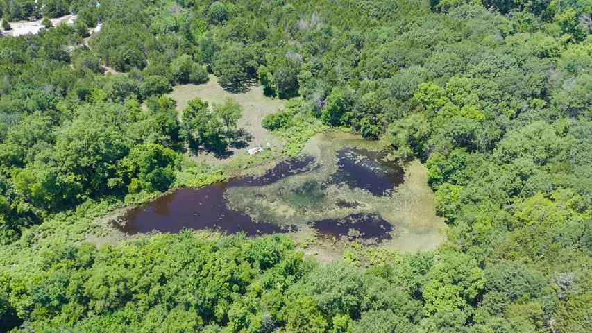
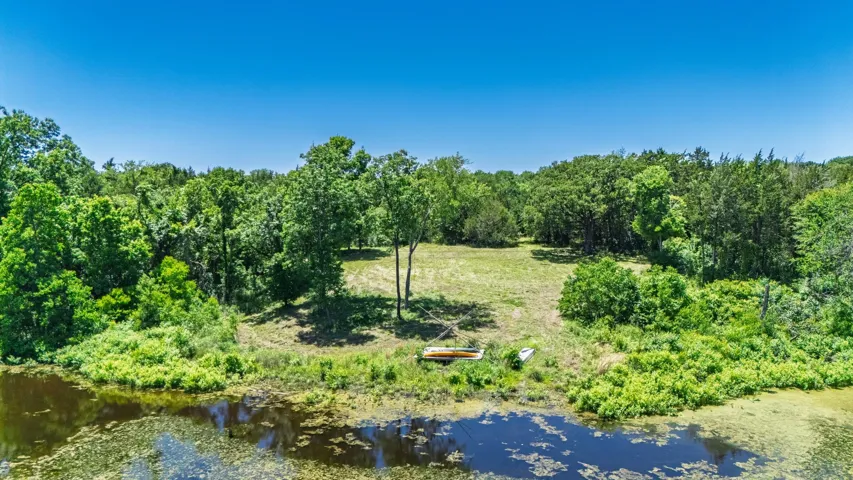
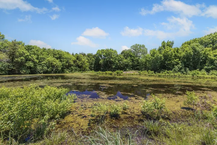
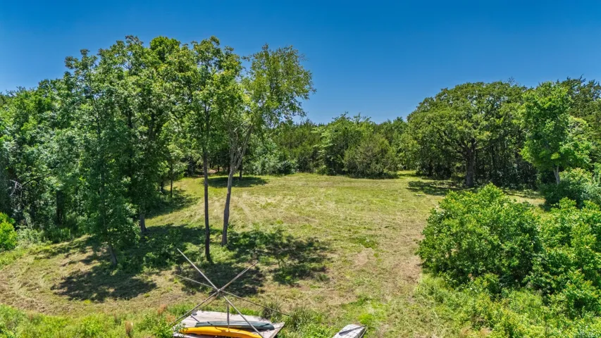
+"PublicRemarks": "Buy Dirt! Beautiful 1.88 acre WATERFRONT lot featuring soaring hardwood trees in one of the premier communities in the Richland Chambers Lake area. Escape the concrete jungle and make the short one hour drive from downtown Dallas to enjoy the peace and tranquility of a slower pace and evenings filled with the biggest stars you have ever seen. Prepare to be amazed by the breath taking canopies offered by the magnificent oak trees covering the property. There is no time limit to start construction, so you have the flexibility to buy now and build your dream home at some point in the future while enjoying your lakefront oasis without any pressure to build until you're ready. 3001 Rock Road is a short drive away from the community boat ramp, or slide up Hwy 287 and launch your watercraft at Oak Cove Marina. Hidden Oaks is deed restricted to site built homes with at least 1,600 square feet of heated & cooled living area."
+"AssociationFee": "450.0"
+"AssociationFeeFrequency": "Annually"
+"AssociationFeeIncludes": "All Facilities"
+"AssociationName": "Hidden Oaks HOA"
+"AssociationPhone": "817-614-4646"
+"AttributionContact": "903-654-7561"
+"CLIP": 2892245650
+"CommunityFeatures": "Dock,Community Mailbox,Lake"
+"Country": "US"
+"CountyOrParish": "Navarro"
+"CreationDate": "2024-06-26T01:01:12.166937+00:00"
+"CumulativeDaysOnMarket": 392
+"CurrentUse": "Residential,Single Family,Unimproved"
+"DevelopmentStatus": "Site Plan Approved,Streets Installed"
+"Directions": "287 South, north on Caddo Trail. Property is at the corner of Caddo Trail and Rock Road. SOP."
+"ElementarySchool": "Mildred"
+"ElementarySchoolDistrict": "Mildred ISD"
+"HighSchool": "Mildred"
+"HighSchoolDistrict": "Mildred ISD"
+"HumanModifiedYN": true
+"RFTransactionType": "For Sale"
+"InternetAutomatedValuationDisplayYN": true
+"InternetConsumerCommentYN": true
+"InternetEntireListingDisplayYN": true
+"ListAgentAOR": "Navarro County Board Of Realtors"
+"ListAgentDirectPhone": "903-654-7561"
+"ListAgentEmail": "aric@thebonnergroup.net"
+"ListAgentFirstName": "Aric"
+"ListAgentKey": "20473129"
+"ListAgentKeyNumeric": "20473129"
+"ListAgentLastName": "Bonner"
+"ListOfficeKey": "4818977"
+"ListOfficeKeyNumeric": "4818977"
+"ListOfficePhone": "903-354-4828"
+"ListingAgreement": "Exclusive Right To Sell"
+"ListingContractDate": "2024-06-19"
+"ListingKeyNumeric": 1076626483
+"ListingTerms": "Cash,Conventional,1031 Exchange,FHA,VA Loan"
+"LockBoxType": "None"
+"LotFeatures": "Acreage,Back Yard,Lawn,Level,Many Trees,Subdivision,Waterfront"
+"LotSizeAcres": 1.88
+"LotSizeSource": "Public Records"
+"LotSizeSquareFeet": 81892.8
+"MajorChangeTimestamp": "2025-05-20T11:23:46Z"
+"MiddleOrJuniorSchool": "Mildred"
+"MlsStatus": "Active"
+"OriginalListPrice": 169900.0
+"OriginatingSystemKey": "440981007"
+"OwnerName": "See Tax"
+"ParcelNumber": "57506"
+"PhotosChangeTimestamp": "2024-06-19T21:20:30Z"
+"PhotosCount": 25
+"Possession": "Negotiable"
+"PossibleUse": "Residential"
+"PostalCodePlus4": "0583"
+"PriceChangeTimestamp": "2025-05-20T11:23:46Z"
+"PrivateRemarks": "Buyer or buyer's representative to verify all information. Information provided is deemed reliable, but not guaranteed. Buyer's representative is encouraged to perform independent due diligence when a purchase decision is being considered."
+"RoadFrontageType": "All Weather Road,Private Road"
+"RoadSurfaceType": "Asphalt"
+"SpecialListingConditions": "Standard"
+"StateOrProvince": "TX"
+"StatusChangeTimestamp": "2024-06-19T16:19:03Z"
+"StreetName": "Rock"
+"StreetNumber": "3001"
+"StreetNumberNumeric": "3001"
+"StreetSuffix": "Road"
+"SubdivisionName": "Hidden Oaks III"
+"SyndicateTo": "Homes.com,IDX Sites,Realtor.com,RPR,Syndication Allowed"
+"TaxAnnualAmount": "1412.0"
+"TaxLegalDescription": "H0180.03 HIDDEN OAKS III LOT 53R 1.88 ACRES"
+"TaxLot": "53R"
+"Utilities": "Electricity Available,None,Overhead Utilities,Water Available"
+"VirtualTourURLUnbranded": "https://www.propertypanorama.com/instaview/ntreis/20651016"
+"WaterBodyName": "Richland-Chambers"
+"WaterfrontFeatures": "Lake Front,Waterfront"
+"WaterfrontYN": true
+"ZoningDescription": "Residential"
+"Restrictions": "Architectural,Building Restrictions,Deed Restrictions,No Mobile Home"
+"GarageDimensions": ",,"
+"TitleCompanyPhone": "(903) 874-3768"
+"TitleCompanyAddress": "500 W 3rd Avenue, Corsicana"
+"TitleCompanyPreferred": "Navarro County Abstract"
+"OriginatingSystemSubName": "NTR_NTREIS"
+"@odata.id": "https://api.realtyfeed.com/reso/odata/Property('1076626483')"
+"provider_name": "NTREIS"
+"RecordSignature": 414971397
+"UniversalParcelId": "urn:reso:upi:2.0:US:48349:57506"
+"CountrySubdivision": "48349"
+"Media": array:25 [
0 => array:54 [
"Order" => 1
"ImageOf" => "Community"
"ListAOR" => "Navarro County Board Of Realtors"
"MediaKey" => "2003319125556"
"MediaURL" => "https://dx41nk9nsacii.cloudfront.net/cdn/119/1076626483/cda9789d2d452f38788a2ebf0b3b7b50.webp"
"ClassName" => null
"MediaHTML" => null
"MediaSize" => 1434107
"MediaType" => "webp"
"Thumbnail" => "https://dx41nk9nsacii.cloudfront.net/cdn/119/1076626483/thumbnail-cda9789d2d452f38788a2ebf0b3b7b50.webp"
"ImageWidth" => null
"Permission" => null
"ImageHeight" => null
"MediaStatus" => null
"SyndicateTo" => "Homes.com,IDX Sites,Realtor.com,RPR,Syndication Allowed"
"ListAgentKey" => "20473129"
"PropertyType" => "Land"
"ResourceName" => "Property"
"ListOfficeKey" => "4818977"
"MediaCategory" => "Photo"
"MediaObjectID" => "IMG_3618.jpg"
"OffMarketDate" => null
"X_MediaStream" => null
"SourceSystemID" => "TRESTLE"
"StandardStatus" => "Active"
"HumanModifiedYN" => false
"ListOfficeMlsId" => null
"LongDescription" => "Cove at the rear of the lot"
"MediaKeyNumeric" => 2003319125556
"PropertySubType" => "Unimproved Land"
"PreferredPhotoYN" => null
"ResourceRecordID" => "20651016"
"ShortDescription" => null
"SourceSystemName" => null
"ChangedByMemberID" => null
"ListingPermission" => null
"PermissionPrivate" => null
"ResourceRecordKey" => "1076626483"
"ChangedByMemberKey" => null
"MediaClassification" => "PHOTO"
"OriginatingSystemID" => null
"ImageSizeDescription" => null
"SourceSystemMediaKey" => null
"ModificationTimestamp" => "2024-06-19T21:19:57.007-00:00"
"OriginatingSystemName" => "NTR"
"OriginatingSystemSubName" => "NTR_NTREIS"
"ResourceRecordKeyNumeric" => 1076626483
"ChangedByMemberKeyNumeric" => null
"OriginatingSystemMediaKey" => "440982736"
"PropertySubTypeAdditional" => "Unimproved Land"
"MediaModificationTimestamp" => "2024-06-19T21:19:57.007-00:00"
"InternetEntireListingDisplayYN" => true
"OriginatingSystemResourceRecordId" => null
"OriginatingSystemResourceRecordKey" => "440981007"
]
1 => array:54 [
"Order" => 2
"ImageOf" => "Other"
"ListAOR" => "Navarro County Board Of Realtors"
"MediaKey" => "2003319125557"
"MediaURL" => "https://dx41nk9nsacii.cloudfront.net/cdn/119/1076626483/7a67ef58f35bc6ff4deabd9d7f28ad9d.webp"
"ClassName" => null
"MediaHTML" => null
"MediaSize" => 1545426
"MediaType" => "webp"
"Thumbnail" => "https://dx41nk9nsacii.cloudfront.net/cdn/119/1076626483/thumbnail-7a67ef58f35bc6ff4deabd9d7f28ad9d.webp"
"ImageWidth" => null
"Permission" => null
"ImageHeight" => null
"MediaStatus" => null
"SyndicateTo" => "Homes.com,IDX Sites,Realtor.com,RPR,Syndication Allowed"
"ListAgentKey" => "20473129"
"PropertyType" => "Land"
"ResourceName" => "Property"
"ListOfficeKey" => "4818977"
"MediaCategory" => "Photo"
"MediaObjectID" => "IMG_3616.jpg"
"OffMarketDate" => null
"X_MediaStream" => null
"SourceSystemID" => "TRESTLE"
"StandardStatus" => "Active"
"HumanModifiedYN" => false
"ListOfficeMlsId" => null
"LongDescription" => "Cove"
"MediaKeyNumeric" => 2003319125557
"PropertySubType" => "Unimproved Land"
"PreferredPhotoYN" => null
"ResourceRecordID" => "20651016"
"ShortDescription" => null
"SourceSystemName" => null
"ChangedByMemberID" => null
"ListingPermission" => null
"PermissionPrivate" => null
"ResourceRecordKey" => "1076626483"
"ChangedByMemberKey" => null
"MediaClassification" => "PHOTO"
"OriginatingSystemID" => null
"ImageSizeDescription" => null
"SourceSystemMediaKey" => null
"ModificationTimestamp" => "2024-06-19T21:19:57.007-00:00"
"OriginatingSystemName" => "NTR"
"OriginatingSystemSubName" => "NTR_NTREIS"
"ResourceRecordKeyNumeric" => 1076626483
"ChangedByMemberKeyNumeric" => null
"OriginatingSystemMediaKey" => "440982737"
"PropertySubTypeAdditional" => "Unimproved Land"
"MediaModificationTimestamp" => "2024-06-19T21:19:57.007-00:00"
"InternetEntireListingDisplayYN" => true
"OriginatingSystemResourceRecordId" => null
"OriginatingSystemResourceRecordKey" => "440981007"
]
2 => array:54 [
"Order" => 3
"ImageOf" => "Other"
"ListAOR" => "Navarro County Board Of Realtors"
"MediaKey" => "2003319125559"
"MediaURL" => "https://dx41nk9nsacii.cloudfront.net/cdn/119/1076626483/5e381b975d2c4299b22aad13dcd42c05.webp"
"ClassName" => null
"MediaHTML" => null
"MediaSize" => 1545858
"MediaType" => "webp"
"Thumbnail" => "https://dx41nk9nsacii.cloudfront.net/cdn/119/1076626483/thumbnail-5e381b975d2c4299b22aad13dcd42c05.webp"
"ImageWidth" => null
"Permission" => null
"ImageHeight" => null
"MediaStatus" => null
"SyndicateTo" => "Homes.com,IDX Sites,Realtor.com,RPR,Syndication Allowed"
"ListAgentKey" => "20473129"
"PropertyType" => "Land"
"ResourceName" => "Property"
"ListOfficeKey" => "4818977"
"MediaCategory" => "Photo"
"MediaObjectID" => "IMG_3615.jpg"
"OffMarketDate" => null
"X_MediaStream" => null
"SourceSystemID" => "TRESTLE"
"StandardStatus" => "Active"
"HumanModifiedYN" => false
"ListOfficeMlsId" => null
"LongDescription" => "View of mother earth's splendor featuring a water view"
"MediaKeyNumeric" => 2003319125559
"PropertySubType" => "Unimproved Land"
"PreferredPhotoYN" => null
"ResourceRecordID" => "20651016"
"ShortDescription" => null
"SourceSystemName" => null
"ChangedByMemberID" => null
"ListingPermission" => null
"PermissionPrivate" => null
"ResourceRecordKey" => "1076626483"
"ChangedByMemberKey" => null
"MediaClassification" => "PHOTO"
"OriginatingSystemID" => null
"ImageSizeDescription" => null
"SourceSystemMediaKey" => null
"ModificationTimestamp" => "2024-06-19T21:19:57.007-00:00"
"OriginatingSystemName" => "NTR"
"OriginatingSystemSubName" => "NTR_NTREIS"
"ResourceRecordKeyNumeric" => 1076626483
"ChangedByMemberKeyNumeric" => null
"OriginatingSystemMediaKey" => "440982739"
"PropertySubTypeAdditional" => "Unimproved Land"
"MediaModificationTimestamp" => "2024-06-19T21:19:57.007-00:00"
"InternetEntireListingDisplayYN" => true
"OriginatingSystemResourceRecordId" => null
"OriginatingSystemResourceRecordKey" => "440981007"
]
3 => array:54 [
"Order" => 4
"ImageOf" => "Aerial View"
"ListAOR" => "Navarro County Board Of Realtors"
"MediaKey" => "2003319125560"
"MediaURL" => "https://dx41nk9nsacii.cloudfront.net/cdn/119/1076626483/a3a1a2163af2f582b9971806e6333b59.webp"
"ClassName" => null
"MediaHTML" => null
"MediaSize" => 981585
"MediaType" => "webp"
"Thumbnail" => "https://dx41nk9nsacii.cloudfront.net/cdn/119/1076626483/thumbnail-a3a1a2163af2f582b9971806e6333b59.webp"
"ImageWidth" => null
"Permission" => null
"ImageHeight" => null
"MediaStatus" => null
"SyndicateTo" => "Homes.com,IDX Sites,Realtor.com,RPR,Syndication Allowed"
"ListAgentKey" => "20473129"
"PropertyType" => "Land"
"ResourceName" => "Property"
"ListOfficeKey" => "4818977"
"MediaCategory" => "Photo"
"MediaObjectID" => "IMG_3608.JPG"
"OffMarketDate" => null
"X_MediaStream" => null
"SourceSystemID" => "TRESTLE"
"StandardStatus" => "Active"
"HumanModifiedYN" => false
"ListOfficeMlsId" => null
"LongDescription" => "Birds eye view of property featuring a water view"
"MediaKeyNumeric" => 2003319125560
"PropertySubType" => "Unimproved Land"
"PreferredPhotoYN" => null
"ResourceRecordID" => "20651016"
"ShortDescription" => null
"SourceSystemName" => null
"ChangedByMemberID" => null
"ListingPermission" => null
"PermissionPrivate" => null
"ResourceRecordKey" => "1076626483"
"ChangedByMemberKey" => null
"MediaClassification" => "PHOTO"
"OriginatingSystemID" => null
"ImageSizeDescription" => null
"SourceSystemMediaKey" => null
"ModificationTimestamp" => "2024-06-19T21:19:57.007-00:00"
"OriginatingSystemName" => "NTR"
"OriginatingSystemSubName" => "NTR_NTREIS"
"ResourceRecordKeyNumeric" => 1076626483
"ChangedByMemberKeyNumeric" => null
"OriginatingSystemMediaKey" => "440982740"
"PropertySubTypeAdditional" => "Unimproved Land"
"MediaModificationTimestamp" => "2024-06-19T21:19:57.007-00:00"
"InternetEntireListingDisplayYN" => true
"OriginatingSystemResourceRecordId" => null
"OriginatingSystemResourceRecordKey" => "440981007"
]
4 => array:54 [
"Order" => 5
"ImageOf" => "Aerial View"
"ListAOR" => "Navarro County Board Of Realtors"
"MediaKey" => "2003319125501"
"MediaURL" => "https://dx41nk9nsacii.cloudfront.net/cdn/119/1076626483/757417f2289f831f08dd5efd55cc37e3.webp"
"ClassName" => null
"MediaHTML" => null
"MediaSize" => 1086318
"MediaType" => "webp"
"Thumbnail" => "https://dx41nk9nsacii.cloudfront.net/cdn/119/1076626483/thumbnail-757417f2289f831f08dd5efd55cc37e3.webp"
"ImageWidth" => null
"Permission" => null
"ImageHeight" => null
"MediaStatus" => null
"SyndicateTo" => "Homes.com,IDX Sites,Realtor.com,RPR,Syndication Allowed"
"ListAgentKey" => "20473129"
"PropertyType" => "Land"
"ResourceName" => "Property"
"ListOfficeKey" => "4818977"
"MediaCategory" => "Photo"
"MediaObjectID" => "IMG_3609.JPG"
"OffMarketDate" => null
"X_MediaStream" => null
"SourceSystemID" => "TRESTLE"
"StandardStatus" => "Active"
"HumanModifiedYN" => false
"ListOfficeMlsId" => null
"LongDescription" => "Drone / aerial view with a water view"
"MediaKeyNumeric" => 2003319125501
"PropertySubType" => "Unimproved Land"
"PreferredPhotoYN" => null
"ResourceRecordID" => "20651016"
"ShortDescription" => null
"SourceSystemName" => null
"ChangedByMemberID" => null
"ListingPermission" => null
"PermissionPrivate" => null
"ResourceRecordKey" => "1076626483"
"ChangedByMemberKey" => null
"MediaClassification" => "PHOTO"
"OriginatingSystemID" => null
"ImageSizeDescription" => null
"SourceSystemMediaKey" => null
"ModificationTimestamp" => "2024-06-19T21:19:57.007-00:00"
"OriginatingSystemName" => "NTR"
"OriginatingSystemSubName" => "NTR_NTREIS"
"ResourceRecordKeyNumeric" => 1076626483
"ChangedByMemberKeyNumeric" => null
"OriginatingSystemMediaKey" => "440982745"
"PropertySubTypeAdditional" => "Unimproved Land"
"MediaModificationTimestamp" => "2024-06-19T21:19:57.007-00:00"
"InternetEntireListingDisplayYN" => true
"OriginatingSystemResourceRecordId" => null
"OriginatingSystemResourceRecordKey" => "440981007"
]
5 => array:54 [
"Order" => 6
"ImageOf" => "Aerial View"
"ListAOR" => "Navarro County Board Of Realtors"
"MediaKey" => "2003319125503"
"MediaURL" => "https://dx41nk9nsacii.cloudfront.net/cdn/119/1076626483/b6c937a3a35967cacf67e610eab3ef75.webp"
"ClassName" => null
"MediaHTML" => null
"MediaSize" => 1108728
"MediaType" => "webp"
"Thumbnail" => "https://dx41nk9nsacii.cloudfront.net/cdn/119/1076626483/thumbnail-b6c937a3a35967cacf67e610eab3ef75.webp"
"ImageWidth" => null
"Permission" => null
"ImageHeight" => null
"MediaStatus" => null
"SyndicateTo" => "Homes.com,IDX Sites,Realtor.com,RPR,Syndication Allowed"
"ListAgentKey" => "20473129"
"PropertyType" => "Land"
"ResourceName" => "Property"
"ListOfficeKey" => "4818977"
"MediaCategory" => "Photo"
"MediaObjectID" => "IMG_3604.JPG"
"OffMarketDate" => null
"X_MediaStream" => null
"SourceSystemID" => "TRESTLE"
"StandardStatus" => "Active"
"HumanModifiedYN" => false
"ListOfficeMlsId" => null
"LongDescription" => "Aerial view looking Northwest"
"MediaKeyNumeric" => 2003319125503
"PropertySubType" => "Unimproved Land"
"PreferredPhotoYN" => null
"ResourceRecordID" => "20651016"
"ShortDescription" => null
"SourceSystemName" => null
"ChangedByMemberID" => null
"ListingPermission" => null
"PermissionPrivate" => null
"ResourceRecordKey" => "1076626483"
"ChangedByMemberKey" => null
"MediaClassification" => "PHOTO"
"OriginatingSystemID" => null
"ImageSizeDescription" => null
"SourceSystemMediaKey" => null
"ModificationTimestamp" => "2024-06-19T21:19:57.007-00:00"
"OriginatingSystemName" => "NTR"
"OriginatingSystemSubName" => "NTR_NTREIS"
"ResourceRecordKeyNumeric" => 1076626483
"ChangedByMemberKeyNumeric" => null
"OriginatingSystemMediaKey" => "440982747"
"PropertySubTypeAdditional" => "Unimproved Land"
"MediaModificationTimestamp" => "2024-06-19T21:19:57.007-00:00"
"InternetEntireListingDisplayYN" => true
"OriginatingSystemResourceRecordId" => null
"OriginatingSystemResourceRecordKey" => "440981007"
]
6 => array:54 [
"Order" => 7
"ImageOf" => "Aerial View"
"ListAOR" => "Navarro County Board Of Realtors"
"MediaKey" => "2003319125507"
"MediaURL" => "https://dx41nk9nsacii.cloudfront.net/cdn/119/1076626483/280f62e01f5fc35148fa20f4ffdfbe23.webp"
"ClassName" => null
"MediaHTML" => null
"MediaSize" => 1504017
"MediaType" => "webp"
"Thumbnail" => "https://dx41nk9nsacii.cloudfront.net/cdn/119/1076626483/thumbnail-280f62e01f5fc35148fa20f4ffdfbe23.webp"
"ImageWidth" => null
"Permission" => null
"ImageHeight" => null
"MediaStatus" => null
"SyndicateTo" => "Homes.com,IDX Sites,Realtor.com,RPR,Syndication Allowed"
"ListAgentKey" => "20473129"
"PropertyType" => "Land"
"ResourceName" => "Property"
"ListOfficeKey" => "4818977"
"MediaCategory" => "Photo"
"MediaObjectID" => "IMG_3605.JPG"
"OffMarketDate" => null
"X_MediaStream" => null
"SourceSystemID" => "TRESTLE"
"StandardStatus" => "Active"
"HumanModifiedYN" => false
"ListOfficeMlsId" => null
"LongDescription" => "Bird's eye view featuring a rural view and a water view"
"MediaKeyNumeric" => 2003319125507
"PropertySubType" => "Unimproved Land"
"PreferredPhotoYN" => null
"ResourceRecordID" => "20651016"
"ShortDescription" => null
"SourceSystemName" => null
"ChangedByMemberID" => null
"ListingPermission" => null
"PermissionPrivate" => null
"ResourceRecordKey" => "1076626483"
"ChangedByMemberKey" => null
"MediaClassification" => "PHOTO"
"OriginatingSystemID" => null
"ImageSizeDescription" => null
"SourceSystemMediaKey" => null
"ModificationTimestamp" => "2024-06-19T21:19:57.007-00:00"
"OriginatingSystemName" => "NTR"
"OriginatingSystemSubName" => "NTR_NTREIS"
"ResourceRecordKeyNumeric" => 1076626483
"ChangedByMemberKeyNumeric" => null
"OriginatingSystemMediaKey" => "440982751"
"PropertySubTypeAdditional" => "Unimproved Land"
"MediaModificationTimestamp" => "2024-06-19T21:19:57.007-00:00"
"InternetEntireListingDisplayYN" => true
"OriginatingSystemResourceRecordId" => null
"OriginatingSystemResourceRecordKey" => "440981007"
]
7 => array:54 [
"Order" => 8
"ImageOf" => "Aerial View"
"ListAOR" => "Navarro County Board Of Realtors"
"MediaKey" => "2003319125511"
"MediaURL" => "https://dx41nk9nsacii.cloudfront.net/cdn/119/1076626483/5f6706d25878584c06be89ae401ab181.webp"
"ClassName" => null
"MediaHTML" => null
"MediaSize" => 1432764
"MediaType" => "webp"
"Thumbnail" => "https://dx41nk9nsacii.cloudfront.net/cdn/119/1076626483/thumbnail-5f6706d25878584c06be89ae401ab181.webp"
"ImageWidth" => null
"Permission" => null
"ImageHeight" => null
"MediaStatus" => null
"SyndicateTo" => "Homes.com,IDX Sites,Realtor.com,RPR,Syndication Allowed"
"ListAgentKey" => "20473129"
"PropertyType" => "Land"
"ResourceName" => "Property"
"ListOfficeKey" => "4818977"
"MediaCategory" => "Photo"
"MediaObjectID" => "IMG_3606.JPG"
"OffMarketDate" => null
"X_MediaStream" => null
"SourceSystemID" => "TRESTLE"
"StandardStatus" => "Active"
"HumanModifiedYN" => false
"ListOfficeMlsId" => null
"LongDescription" => "Bird's eye view with a rural view and a water view"
"MediaKeyNumeric" => 2003319125511
"PropertySubType" => "Unimproved Land"
"PreferredPhotoYN" => null
"ResourceRecordID" => "20651016"
"ShortDescription" => null
"SourceSystemName" => null
"ChangedByMemberID" => null
"ListingPermission" => null
"PermissionPrivate" => null
"ResourceRecordKey" => "1076626483"
"ChangedByMemberKey" => null
"MediaClassification" => "PHOTO"
"OriginatingSystemID" => null
"ImageSizeDescription" => null
"SourceSystemMediaKey" => null
"ModificationTimestamp" => "2024-06-19T21:19:57.007-00:00"
"OriginatingSystemName" => "NTR"
"OriginatingSystemSubName" => "NTR_NTREIS"
"ResourceRecordKeyNumeric" => 1076626483
"ChangedByMemberKeyNumeric" => null
"OriginatingSystemMediaKey" => "440982755"
"PropertySubTypeAdditional" => "Unimproved Land"
"MediaModificationTimestamp" => "2024-06-19T21:19:57.007-00:00"
"InternetEntireListingDisplayYN" => true
"OriginatingSystemResourceRecordId" => null
"OriginatingSystemResourceRecordKey" => "440981007"
]
8 => array:54 [
"Order" => 9
"ImageOf" => "Aerial View"
"ListAOR" => "Navarro County Board Of Realtors"
"MediaKey" => "2003319207691"
"MediaURL" => "https://dx41nk9nsacii.cloudfront.net/cdn/119/1076626483/b850f5c336cc35ab15af960c15c21836.webp"
"ClassName" => null
"MediaHTML" => null
"MediaSize" => 819052
"MediaType" => "webp"
"Thumbnail" => "https://dx41nk9nsacii.cloudfront.net/cdn/119/1076626483/thumbnail-b850f5c336cc35ab15af960c15c21836.webp"
"ImageWidth" => null
"Permission" => null
"ImageHeight" => null
"MediaStatus" => null
"SyndicateTo" => "Homes.com,IDX Sites,Realtor.com,RPR,Syndication Allowed"
"ListAgentKey" => "20473129"
"PropertyType" => "Land"
"ResourceName" => "Property"
"ListOfficeKey" => "4818977"
"MediaCategory" => "Photo"
"MediaObjectID" => "Lot Line - 2.jpg"
"OffMarketDate" => null
"X_MediaStream" => null
"SourceSystemID" => "TRESTLE"
"StandardStatus" => "Active"
"HumanModifiedYN" => false
"ListOfficeMlsId" => null
"LongDescription" => "Approximate lot configuration - 168 ft. of shoreline"
"MediaKeyNumeric" => 2003319207691
"PropertySubType" => "Unimproved Land"
"PreferredPhotoYN" => null
"ResourceRecordID" => "20651016"
"ShortDescription" => null
"SourceSystemName" => null
"ChangedByMemberID" => null
"ListingPermission" => null
"PermissionPrivate" => null
"ResourceRecordKey" => "1076626483"
"ChangedByMemberKey" => null
"MediaClassification" => "PHOTO"
"OriginatingSystemID" => null
"ImageSizeDescription" => null
"SourceSystemMediaKey" => null
"ModificationTimestamp" => "2024-06-19T21:19:57.007-00:00"
"OriginatingSystemName" => "NTR"
"OriginatingSystemSubName" => "NTR_NTREIS"
"ResourceRecordKeyNumeric" => 1076626483
"ChangedByMemberKeyNumeric" => null
"OriginatingSystemMediaKey" => "440985877"
"PropertySubTypeAdditional" => "Unimproved Land"
"MediaModificationTimestamp" => "2024-06-19T21:19:57.007-00:00"
"InternetEntireListingDisplayYN" => true
"OriginatingSystemResourceRecordId" => null
"OriginatingSystemResourceRecordKey" => "440981007"
]
9 => array:54 [
"Order" => 10
"ImageOf" => "Aerial View"
"ListAOR" => "Navarro County Board Of Realtors"
"MediaKey" => "2003319125514"
"MediaURL" => "https://dx41nk9nsacii.cloudfront.net/cdn/119/1076626483/d1d139b76a28abbec2ca9e37ec99409a.webp"
"ClassName" => null
"MediaHTML" => null
"MediaSize" => 1023681
"MediaType" => "webp"
"Thumbnail" => "https://dx41nk9nsacii.cloudfront.net/cdn/119/1076626483/thumbnail-d1d139b76a28abbec2ca9e37ec99409a.webp"
"ImageWidth" => null
"Permission" => null
"ImageHeight" => null
"MediaStatus" => null
"SyndicateTo" => "Homes.com,IDX Sites,Realtor.com,RPR,Syndication Allowed"
"ListAgentKey" => "20473129"
"PropertyType" => "Land"
"ResourceName" => "Property"
"ListOfficeKey" => "4818977"
"MediaCategory" => "Photo"
"MediaObjectID" => "IMG_3607.JPG"
"OffMarketDate" => null
"X_MediaStream" => null
"SourceSystemID" => "TRESTLE"
"StandardStatus" => "Active"
"HumanModifiedYN" => false
"ListOfficeMlsId" => null
"LongDescription" => "Drone / aerial view with a water view"
"MediaKeyNumeric" => 2003319125514
"PropertySubType" => "Unimproved Land"
"PreferredPhotoYN" => null
"ResourceRecordID" => "20651016"
"ShortDescription" => null
"SourceSystemName" => null
"ChangedByMemberID" => null
"ListingPermission" => null
"PermissionPrivate" => null
"ResourceRecordKey" => "1076626483"
"ChangedByMemberKey" => null
"MediaClassification" => "PHOTO"
"OriginatingSystemID" => null
"ImageSizeDescription" => null
"SourceSystemMediaKey" => null
"ModificationTimestamp" => "2024-06-19T21:19:57.007-00:00"
"OriginatingSystemName" => "NTR"
"OriginatingSystemSubName" => "NTR_NTREIS"
"ResourceRecordKeyNumeric" => 1076626483
"ChangedByMemberKeyNumeric" => null
"OriginatingSystemMediaKey" => "440982758"
"PropertySubTypeAdditional" => "Unimproved Land"
"MediaModificationTimestamp" => "2024-06-19T21:19:57.007-00:00"
"InternetEntireListingDisplayYN" => true
"OriginatingSystemResourceRecordId" => null
"OriginatingSystemResourceRecordKey" => "440981007"
]
10 => array:54 [
"Order" => 11
"ImageOf" => "Aerial View"
"ListAOR" => "Navarro County Board Of Realtors"
"MediaKey" => "2003319125517"
"MediaURL" => "https://dx41nk9nsacii.cloudfront.net/cdn/119/1076626483/d11b8482a8dbde3f776f4435898243ce.webp"
"ClassName" => null
"MediaHTML" => null
"MediaSize" => 1358562
"MediaType" => "webp"
"Thumbnail" => "https://dx41nk9nsacii.cloudfront.net/cdn/119/1076626483/thumbnail-d11b8482a8dbde3f776f4435898243ce.webp"
"ImageWidth" => null
"Permission" => null
"ImageHeight" => null
"MediaStatus" => null
"SyndicateTo" => "Homes.com,IDX Sites,Realtor.com,RPR,Syndication Allowed"
"ListAgentKey" => "20473129"
"PropertyType" => "Land"
"ResourceName" => "Property"
"ListOfficeKey" => "4818977"
"MediaCategory" => "Photo"
"MediaObjectID" => "IMG_3610.JPG"
"OffMarketDate" => null
"X_MediaStream" => null
"SourceSystemID" => "TRESTLE"
"StandardStatus" => "Active"
"HumanModifiedYN" => false
"ListOfficeMlsId" => null
"LongDescription" => "Birds eye view of property"
"MediaKeyNumeric" => 2003319125517
"PropertySubType" => "Unimproved Land"
"PreferredPhotoYN" => null
"ResourceRecordID" => "20651016"
"ShortDescription" => null
"SourceSystemName" => null
"ChangedByMemberID" => null
"ListingPermission" => null
"PermissionPrivate" => null
"ResourceRecordKey" => "1076626483"
"ChangedByMemberKey" => null
"MediaClassification" => "PHOTO"
"OriginatingSystemID" => null
"ImageSizeDescription" => null
"SourceSystemMediaKey" => null
"ModificationTimestamp" => "2024-06-19T21:19:57.007-00:00"
"OriginatingSystemName" => "NTR"
"OriginatingSystemSubName" => "NTR_NTREIS"
"ResourceRecordKeyNumeric" => 1076626483
"ChangedByMemberKeyNumeric" => null
"OriginatingSystemMediaKey" => "440982761"
"PropertySubTypeAdditional" => "Unimproved Land"
"MediaModificationTimestamp" => "2024-06-19T21:19:57.007-00:00"
"InternetEntireListingDisplayYN" => true
"OriginatingSystemResourceRecordId" => null
"OriginatingSystemResourceRecordKey" => "440981007"
]
11 => array:54 [
"Order" => 12
"ImageOf" => "Aerial View"
"ListAOR" => "Navarro County Board Of Realtors"
"MediaKey" => "2003319125536"
"MediaURL" => "https://dx41nk9nsacii.cloudfront.net/cdn/119/1076626483/971277dee5ab4a157ae101de8473fd2c.webp"
"ClassName" => null
"MediaHTML" => null
"MediaSize" => 1333318
"MediaType" => "webp"
"Thumbnail" => "https://dx41nk9nsacii.cloudfront.net/cdn/119/1076626483/thumbnail-971277dee5ab4a157ae101de8473fd2c.webp"
"ImageWidth" => null
"Permission" => null
"ImageHeight" => null
"MediaStatus" => null
"SyndicateTo" => "Homes.com,IDX Sites,Realtor.com,RPR,Syndication Allowed"
"ListAgentKey" => "20473129"
"PropertyType" => "Land"
"ResourceName" => "Property"
"ListOfficeKey" => "4818977"
"MediaCategory" => "Photo"
"MediaObjectID" => "IMG_3611.JPG"
"OffMarketDate" => null
"X_MediaStream" => null
"SourceSystemID" => "TRESTLE"
"StandardStatus" => "Active"
"HumanModifiedYN" => false
"ListOfficeMlsId" => null
"LongDescription" => "View of drone / aerial view"
"MediaKeyNumeric" => 2003319125536
"PropertySubType" => "Unimproved Land"
"PreferredPhotoYN" => null
"ResourceRecordID" => "20651016"
"ShortDescription" => null
"SourceSystemName" => null
"ChangedByMemberID" => null
"ListingPermission" => null
"PermissionPrivate" => null
"ResourceRecordKey" => "1076626483"
"ChangedByMemberKey" => null
"MediaClassification" => "PHOTO"
"OriginatingSystemID" => null
"ImageSizeDescription" => null
"SourceSystemMediaKey" => null
"ModificationTimestamp" => "2024-06-19T21:19:57.007-00:00"
"OriginatingSystemName" => "NTR"
"OriginatingSystemSubName" => "NTR_NTREIS"
"ResourceRecordKeyNumeric" => 1076626483
"ChangedByMemberKeyNumeric" => null
"OriginatingSystemMediaKey" => "440982764"
"PropertySubTypeAdditional" => "Unimproved Land"
"MediaModificationTimestamp" => "2024-06-19T21:19:57.007-00:00"
"InternetEntireListingDisplayYN" => true
"OriginatingSystemResourceRecordId" => null
"OriginatingSystemResourceRecordKey" => "440981007"
]
12 => array:54 [
"Order" => 13
"ImageOf" => "Yard"
"ListAOR" => "Navarro County Board Of Realtors"
"MediaKey" => "2003319125542"
"MediaURL" => "https://dx41nk9nsacii.cloudfront.net/cdn/119/1076626483/3a15e9f693cb9badc862ef0b14d20327.webp"
"ClassName" => null
"MediaHTML" => null
"MediaSize" => 1578536
"MediaType" => "webp"
"Thumbnail" => "https://dx41nk9nsacii.cloudfront.net/cdn/119/1076626483/thumbnail-3a15e9f693cb9badc862ef0b14d20327.webp"
"ImageWidth" => null
"Permission" => null
"ImageHeight" => null
"MediaStatus" => null
"SyndicateTo" => "Homes.com,IDX Sites,Realtor.com,RPR,Syndication Allowed"
"ListAgentKey" => "20473129"
"PropertyType" => "Land"
"ResourceName" => "Property"
"ListOfficeKey" => "4818977"
"MediaCategory" => "Photo"
"MediaObjectID" => "IMG_3612.jpg"
"OffMarketDate" => null
"X_MediaStream" => null
"SourceSystemID" => "TRESTLE"
"StandardStatus" => "Active"
"HumanModifiedYN" => false
"ListOfficeMlsId" => null
"LongDescription" => "View of yard featuring a water view"
"MediaKeyNumeric" => 2003319125542
"PropertySubType" => "Unimproved Land"
"PreferredPhotoYN" => null
"ResourceRecordID" => "20651016"
"ShortDescription" => null
"SourceSystemName" => null
"ChangedByMemberID" => null
"ListingPermission" => null
"PermissionPrivate" => null
"ResourceRecordKey" => "1076626483"
"ChangedByMemberKey" => null
"MediaClassification" => "PHOTO"
"OriginatingSystemID" => null
"ImageSizeDescription" => null
"SourceSystemMediaKey" => null
"ModificationTimestamp" => "2024-06-19T21:19:57.007-00:00"
"OriginatingSystemName" => "NTR"
"OriginatingSystemSubName" => "NTR_NTREIS"
"ResourceRecordKeyNumeric" => 1076626483
"ChangedByMemberKeyNumeric" => null
"OriginatingSystemMediaKey" => "440982770"
"PropertySubTypeAdditional" => "Unimproved Land"
"MediaModificationTimestamp" => "2024-06-19T21:19:57.007-00:00"
"InternetEntireListingDisplayYN" => true
"OriginatingSystemResourceRecordId" => null
"OriginatingSystemResourceRecordKey" => "440981007"
]
13 => array:54 [
"Order" => 14
"ImageOf" => "Yard"
"ListAOR" => "Navarro County Board Of Realtors"
"MediaKey" => "2003319125545"
"MediaURL" => "https://dx41nk9nsacii.cloudfront.net/cdn/119/1076626483/2374343d8f958e489e102c29b76fc68b.webp"
"ClassName" => null
"MediaHTML" => null
"MediaSize" => 1454878
"MediaType" => "webp"
"Thumbnail" => "https://dx41nk9nsacii.cloudfront.net/cdn/119/1076626483/thumbnail-2374343d8f958e489e102c29b76fc68b.webp"
"ImageWidth" => null
"Permission" => null
"ImageHeight" => null
"MediaStatus" => null
"SyndicateTo" => "Homes.com,IDX Sites,Realtor.com,RPR,Syndication Allowed"
"ListAgentKey" => "20473129"
"PropertyType" => "Land"
"ResourceName" => "Property"
"ListOfficeKey" => "4818977"
"MediaCategory" => "Photo"
"MediaObjectID" => "IMG_3613.jpg"
"OffMarketDate" => null
"X_MediaStream" => null
"SourceSystemID" => "TRESTLE"
"StandardStatus" => "Active"
"HumanModifiedYN" => false
"ListOfficeMlsId" => null
"LongDescription" => "Property View"
"MediaKeyNumeric" => 2003319125545
"PropertySubType" => "Unimproved Land"
"PreferredPhotoYN" => null
"ResourceRecordID" => "20651016"
"ShortDescription" => null
"SourceSystemName" => null
"ChangedByMemberID" => null
"ListingPermission" => null
"PermissionPrivate" => null
"ResourceRecordKey" => "1076626483"
"ChangedByMemberKey" => null
"MediaClassification" => "PHOTO"
"OriginatingSystemID" => null
"ImageSizeDescription" => null
"SourceSystemMediaKey" => null
"ModificationTimestamp" => "2024-06-19T21:19:57.007-00:00"
"OriginatingSystemName" => "NTR"
"OriginatingSystemSubName" => "NTR_NTREIS"
"ResourceRecordKeyNumeric" => 1076626483
"ChangedByMemberKeyNumeric" => null
"OriginatingSystemMediaKey" => "440982773"
"PropertySubTypeAdditional" => "Unimproved Land"
"MediaModificationTimestamp" => "2024-06-19T21:19:57.007-00:00"
"InternetEntireListingDisplayYN" => true
"OriginatingSystemResourceRecordId" => null
"OriginatingSystemResourceRecordKey" => "440981007"
]
14 => array:54 [
"Order" => 15
"ImageOf" => "Yard"
"ListAOR" => "Navarro County Board Of Realtors"
"MediaKey" => "2003319125548"
"MediaURL" => "https://dx41nk9nsacii.cloudfront.net/cdn/119/1076626483/51b65ef095c767ab7441a3971ab513b9.webp"
"ClassName" => null
"MediaHTML" => null
"MediaSize" => 1497637
"MediaType" => "webp"
"Thumbnail" => "https://dx41nk9nsacii.cloudfront.net/cdn/119/1076626483/thumbnail-51b65ef095c767ab7441a3971ab513b9.webp"
"ImageWidth" => null
"Permission" => null
"ImageHeight" => null
"MediaStatus" => null
"SyndicateTo" => "Homes.com,IDX Sites,Realtor.com,RPR,Syndication Allowed"
"ListAgentKey" => "20473129"
"PropertyType" => "Land"
"ResourceName" => "Property"
"ListOfficeKey" => "4818977"
"MediaCategory" => "Photo"
"MediaObjectID" => "IMG_3614.jpg"
"OffMarketDate" => null
"X_MediaStream" => null
"SourceSystemID" => "TRESTLE"
"StandardStatus" => "Active"
"HumanModifiedYN" => false
"ListOfficeMlsId" => null
"LongDescription" => "View of yard featuring a water view"
"MediaKeyNumeric" => 2003319125548
"PropertySubType" => "Unimproved Land"
"PreferredPhotoYN" => null
"ResourceRecordID" => "20651016"
"ShortDescription" => null
"SourceSystemName" => null
"ChangedByMemberID" => null
"ListingPermission" => null
"PermissionPrivate" => null
"ResourceRecordKey" => "1076626483"
"ChangedByMemberKey" => null
"MediaClassification" => "PHOTO"
"OriginatingSystemID" => null
"ImageSizeDescription" => null
"SourceSystemMediaKey" => null
"ModificationTimestamp" => "2024-06-19T21:19:57.007-00:00"
"OriginatingSystemName" => "NTR"
"OriginatingSystemSubName" => "NTR_NTREIS"
"ResourceRecordKeyNumeric" => 1076626483
"ChangedByMemberKeyNumeric" => null
"OriginatingSystemMediaKey" => "440982776"
"PropertySubTypeAdditional" => "Unimproved Land"
"MediaModificationTimestamp" => "2024-06-19T21:19:57.007-00:00"
"InternetEntireListingDisplayYN" => true
"OriginatingSystemResourceRecordId" => null
"OriginatingSystemResourceRecordKey" => "440981007"
]
15 => array:54 [
"Order" => 16
"ImageOf" => "Yard"
"ListAOR" => "Navarro County Board Of Realtors"
"MediaKey" => "2003319125553"
"MediaURL" => "https://dx41nk9nsacii.cloudfront.net/cdn/119/1076626483/85e916fc871d311271295398d6b79ff7.webp"
"ClassName" => null
"MediaHTML" => null
"MediaSize" => 1625087
"MediaType" => "webp"
"Thumbnail" => "https://dx41nk9nsacii.cloudfront.net/cdn/119/1076626483/thumbnail-85e916fc871d311271295398d6b79ff7.webp"
"ImageWidth" => null
"Permission" => null
"ImageHeight" => null
"MediaStatus" => null
"SyndicateTo" => "Homes.com,IDX Sites,Realtor.com,RPR,Syndication Allowed"
"ListAgentKey" => "20473129"
"PropertyType" => "Land"
"ResourceName" => "Property"
"ListOfficeKey" => "4818977"
"MediaCategory" => "Photo"
"MediaObjectID" => "IMG_3619.jpg"
"OffMarketDate" => null
"X_MediaStream" => null
"SourceSystemID" => "TRESTLE"
"StandardStatus" => "Active"
"HumanModifiedYN" => false
"ListOfficeMlsId" => null
"LongDescription" => "Property View"
"MediaKeyNumeric" => 2003319125553
"PropertySubType" => "Unimproved Land"
"PreferredPhotoYN" => null
"ResourceRecordID" => "20651016"
"ShortDescription" => null
"SourceSystemName" => null
"ChangedByMemberID" => null
"ListingPermission" => null
"PermissionPrivate" => null
"ResourceRecordKey" => "1076626483"
"ChangedByMemberKey" => null
"MediaClassification" => "PHOTO"
"OriginatingSystemID" => null
"ImageSizeDescription" => null
"SourceSystemMediaKey" => null
"ModificationTimestamp" => "2024-06-19T21:19:57.007-00:00"
"OriginatingSystemName" => "NTR"
"OriginatingSystemSubName" => "NTR_NTREIS"
"ResourceRecordKeyNumeric" => 1076626483
"ChangedByMemberKeyNumeric" => null
"OriginatingSystemMediaKey" => "440982781"
…5
]
16 => array:54 [ …54]
17 => array:54 [ …54]
18 => array:54 [ …54]
19 => array:54 [ …54]
20 => array:54 [ …54]
21 => array:54 [ …54]
22 => array:54 [ …54]
23 => array:54 [ …54]
24 => array:54 [ …54]
]
+"ID": "36604"
}
1 => Realtyna\MlsOnTheFly\Components\CloudPost\SubComponents\RFClient\SDK\RF\Entities\RFProperty {#4628
+post_id: "145203"
+post_author: 1
+"ListingKey": "1114773652"
+"ListingId": "20953337"
+"PropertyType": "Land"
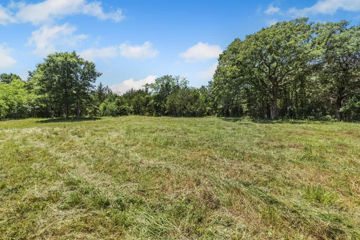
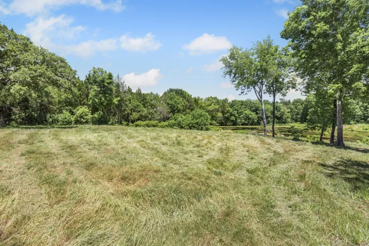
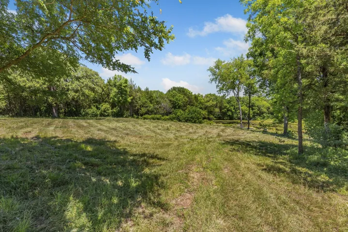
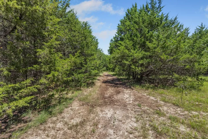
+"PropertySubType": "Improved Land"
+"StandardStatus": "Active"
+"ModificationTimestamp": "2025-07-16T15:46:46Z"
+"RFModificationTimestamp": "2025-07-16T16:10:49Z"
+"ListPrice": 475000.0
+"BathroomsTotalInteger": 0
+"BathroomsHalf": 0
+"BedroomsTotal": 0
+"LotSizeArea": 20.0
+"LivingArea": 0
+"BuildingAreaTotal": 0
+"City": "Wills Point"
+"PostalCode": "75169"
+"UnparsedAddress": "3670 Fm 2475, Wills Point, Texas 75169"
+"Coordinates": array:2 [
0 => -95.971099
1 => 32.799701
]
+"Latitude": 32.799701
+"Longitude": -95.971099
+"YearBuilt": 0
+"InternetAddressDisplayYN": true
+"FeedTypes": "IDX"
+"ListAgentFullName": "Joanna Arnwine"
+"ListOfficeName": "RE/MAX Four Corners"
+"ListAgentMlsId": "0539674"
+"ListOfficeMlsId": "RMFC01C"
+"OriginatingSystemName": "NTR"
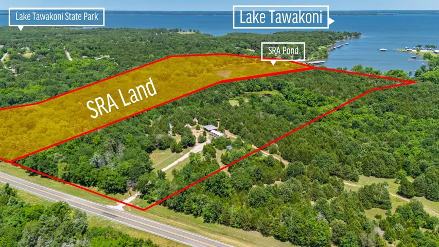
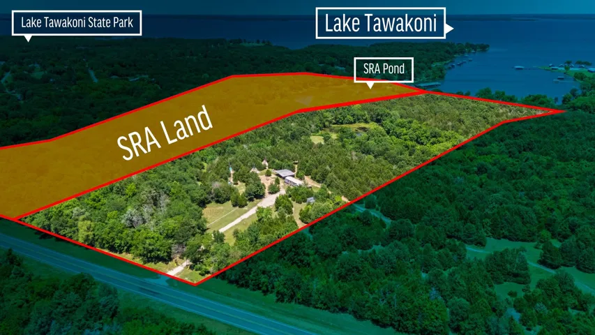
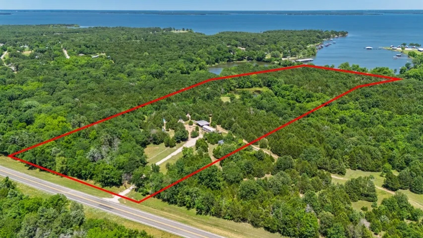
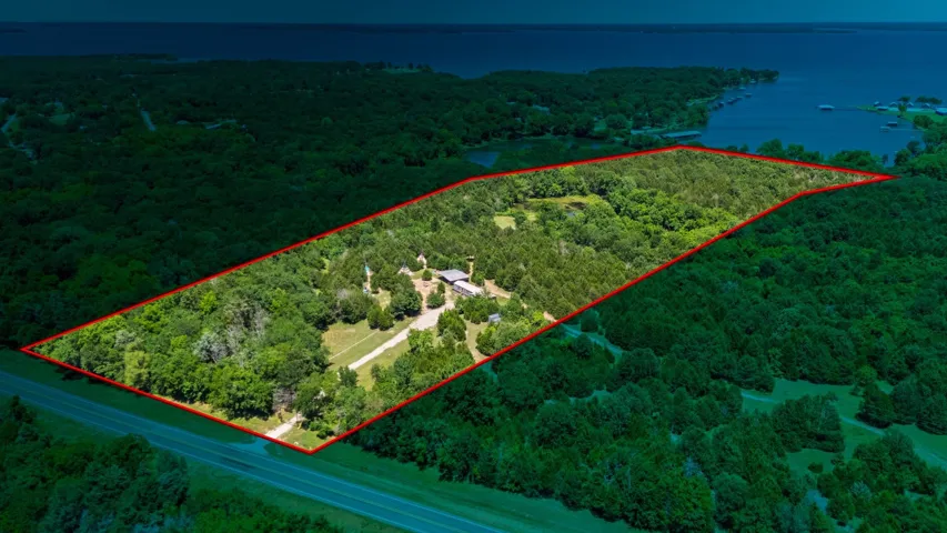
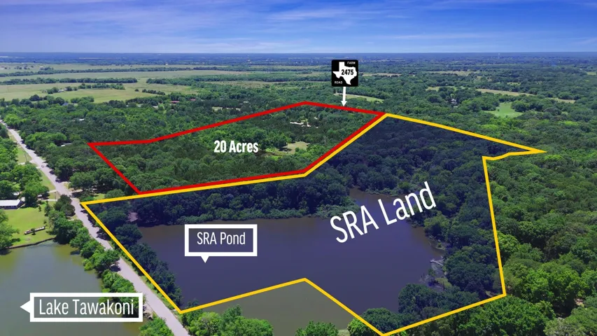
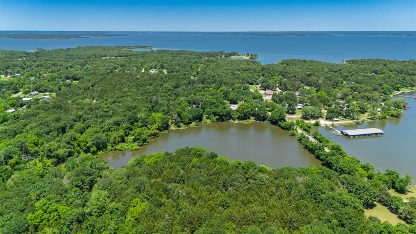
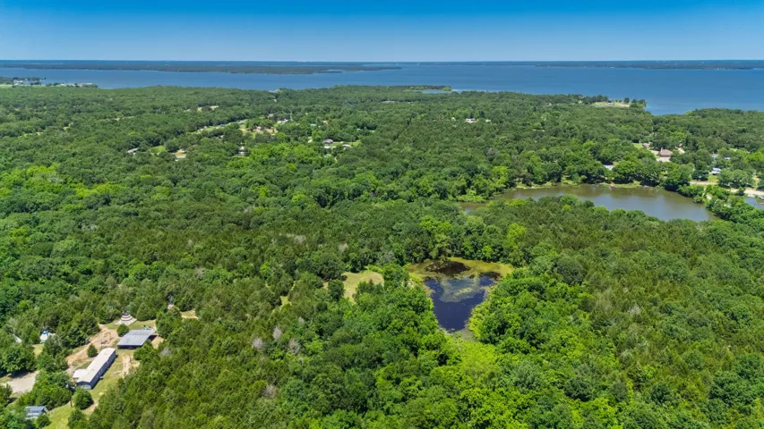
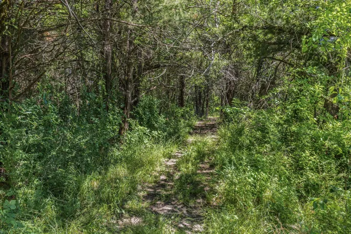
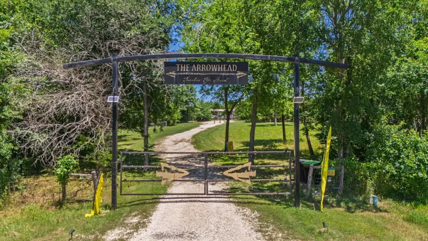
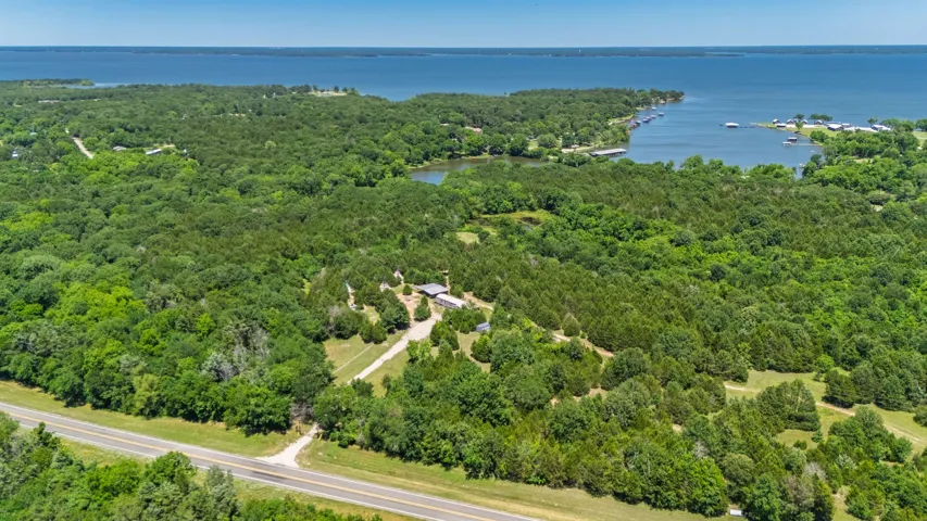
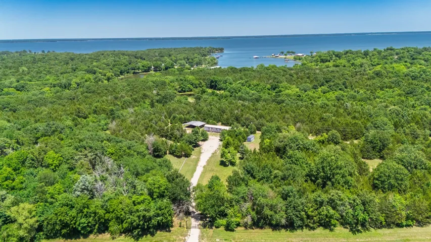
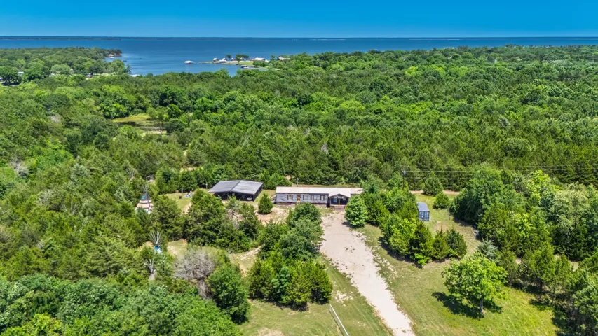
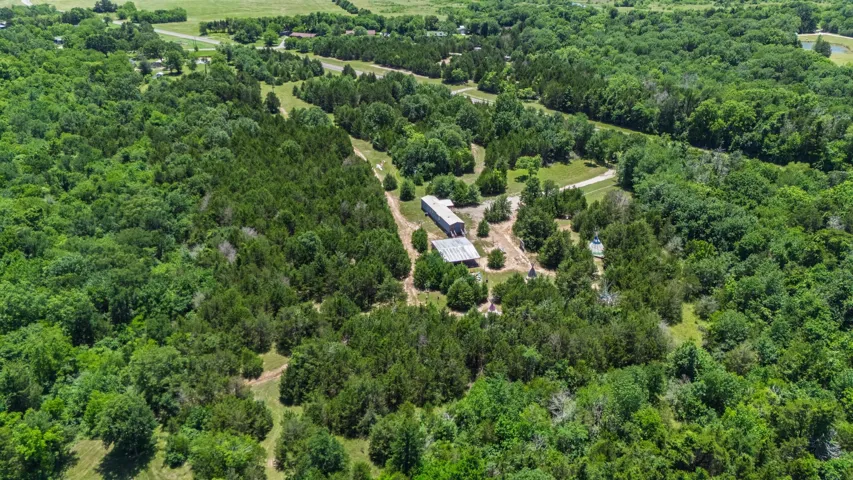
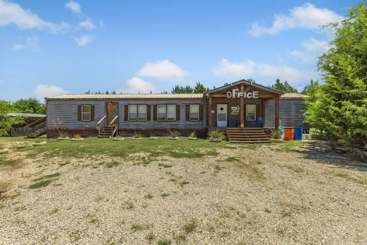
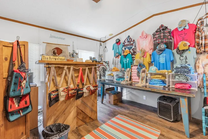
+"PublicRemarks": "A truly unique property with endless possibilities whether you are looking to build your dream home or looking for the perfect weekend getaway to enjoy the peace and quiet of the country! Located just one hour East of the Metroplex with quick Hwy access for an easy commute! Also situated just one mile South of the Lake Tawakoni State Park which features a 4-lane public boat ramp, 376 acres of oak forest, five miles of lakeshore, hiking trails, swimming, fishing, and so much more! The lake itself spans over 37,000 acres and is known for its recreation as well as its stock of catfish, crappie, and bass! The property boasts 20 Acres with beautiful mature trees, gated entrance, gravel drive, and a large pond approximately 1 acre in size! Water, electric, aerobic septic, and internet in place! There is a mobile home on-site that will convey! The home is used as community bathrooms, office, lobby, and make ready areas for the business currently being operated on-site. There is a floorplan sketch available in the transaction folder. There are a total of 3.1 baths with exterior access. Inside you will find 2 bedrooms, 1 full bath, laundry, living, kitchen, and breakfast area. Property sits adjacent to a large area of SRA leaseback of which the current owner leases a large portion including waterfront access to the lake cove on the West side of CR 3829 fed by Caney Creek as shown in the aerial photos! There is no direct access to open water via a boat, but you can take a kayak through the culvert! There is tons of wildlife in the area and excellent fishing in both the large cove as well as the pond on the deeded acreage! Enjoy hunting, fishing, and hiking trails of your very own while also having access to all that the State Park offers just minutes away! Bring your fishing pole, your binoculars, and your hiking shoes! Imagine yourself with a place like this to call home! Must have an appointment and agent present to view the property due to current business on-site!"
+"AttributionContact": "972-396-9100"
+"CLIP": 1171244855
+"CoListAgentDirectPhone": "903-456-9021"
+"CoListAgentEmail": "Haileyarnwine4@gmail.com"
+"CoListAgentFirstName": "Hailey"
+"CoListAgentFullName": "Hailey Alexander"
+"CoListAgentHomePhone": "903-456-9021"
+"CoListAgentKey": "21249491"
+"CoListAgentKeyNumeric": "21249491"
+"CoListAgentLastName": "Alexander"
+"CoListAgentMlsId": "0785729"
+"CoListOfficeKey": "4508080"
+"CoListOfficeKeyNumeric": "4508080"
+"CoListOfficeMlsId": "RMFC01C"
+"CoListOfficeName": "RE/MAX Four Corners"
+"CoListOfficePhone": "972-396-9100"
+"Cooling": "Central Air,Ceiling Fan(s),Electric"
+"CoolingYN": true
+"Country": "US"
+"CountyOrParish": "Van Zandt"
+"CreationDate": "2025-06-01T19:57:34.220384+00:00"
+"CumulativeDaysOnMarket": 45
+"CurrentUse": "Agricultural,Commercial,Hunting,Mobile Home,Other"
+"Directions": "GPS is correct! Sign on Property!"
+"DocumentsAvailable": "Floorplan, Aerial"
+"ElementarySchool": "Willspoint"
+"ElementarySchoolDistrict": "Wills Point ISD"
+"Exclusions": "Arrows and Arrowhead Tipi Resort signage on the front gate, all business personal property, tipis and platforms, and shipping container!"
+"ExteriorFeatures": "Awning(s)"
+"Fencing": "Barbed Wire,Partial"
+"Heating": "Central, Electric"
+"HeatingYN": true
+"HighSchool": "Willspoint"
+"HighSchoolDistrict": "Wills Point ISD"
+"RFTransactionType": "For Sale"
+"InternetAutomatedValuationDisplayYN": true
+"InternetConsumerCommentYN": true
+"InternetEntireListingDisplayYN": true
+"ListAgentAOR": "Collin County Association of Realtors Inc"
+"ListAgentDirectPhone": "903-456-5232"
+"ListAgentEmail": "joanna.arnwine@gmail.com"
+"ListAgentFirstName": "Joanna"
+"ListAgentKey": "20477477"
+"ListAgentKeyNumeric": "20477477"
+"ListAgentLastName": "Arnwine"
+"ListAgentMiddleName": "D"
+"ListOfficeKey": "4508080"
+"ListOfficeKeyNumeric": "4508080"
+"ListOfficePhone": "972-396-9100"
+"ListingAgreement": "Exclusive Right To Sell"
+"ListingContractDate": "2025-06-01"
+"ListingKeyNumeric": 1114773652
+"ListingTerms": "Cash,Conventional,1031 Exchange,Federal Land Bank"
+"LockBoxType": "Supra"
+"LotFeatures": "Acreage,Agricultural,Irregular Lot,Pond on Lot,Many Trees,Waterfront"
+"LotSizeAcres": 20.0
+"LotSizeSource": "Other"
+"LotSizeSquareFeet": 871200.0
+"MajorChangeTimestamp": "2025-06-01T14:50:35Z"
+"MiddleOrJuniorSchool": "Willspoint"
+"MlsStatus": "Active"
+"OccupantType": "Owner"
+"OriginalListPrice": 475000.0
+"OriginatingSystemKey": "456094690"
+"OwnerName": "See Tax"
+"ParcelNumber": "R000113235"
+"PatioAndPorchFeatures": "Covered"
+"PhotosChangeTimestamp": "2025-06-01T19:51:30Z"
+"PhotosCount": 40
+"Possession": "Negotiable"
+"PossibleUse": "Agricultural,Cattle,Commercial,Grazing,Horses,Hunting,Investment,Livestock,Mobile Home,Mixed Use,Pasture,Ranch,Residential,Recreational,Single Family"
+"PostalCodePlus4": "6823"
+"PrivateOfficeRemarks": "DO NOT send your clients out to walk the property without an appointment. The Arrowhead Tipi Resort is still hosting guests. Agents must be present with their clients and schedule a showing through Broker Bay!"
+"PrivateRemarks": "Tax office currently has 8 acres under commercial use. Per the appraisal district office this can be changed after the first of the year if the new owner does not intend to use the property for any commercial purposes. The remaining 12 acres are under a forestry ag exemption. The total of 20 acres is being surveyed out of a larger tract according to the approximate sketches found in the transaction folder. Aerial photos are approximate. Current owner leases a large portion of the adjacent SRA land which includes waterfront access to the lake cove on the West side of CR 3829 fed by Caney Creek as shown in aerial photos. There is no direct access to the open water of the lake from this cove by boat, but you can take a Kayak through the culvert. SRA leases are not transferrable. Buyer will have to sign a new lease with SRA. Buyer to complete all due diligence for any Tax questions or SRA questions with the appropriate offices."
+"RoadFrontageType": "Farm to Market Road,All Weather Road"
+"RoadSurfaceType": "Asphalt"
+"Sewer": "Aerobic Septic"
+"ShowingContactPhone": "(800) 257-1242"
+"ShowingContactType": "Showing Service"
+"ShowingInstructions": """
Do Not send your clients out to walk the property without an appointment. \r\n
Agent must be present!
"""
+"ShowingRequirements": "Appointment Only"
+"SpecialListingConditions": "Standard"
+"StateOrProvince": "TX"
+"StatusChangeTimestamp": "2025-06-01T14:50:35Z"
+"StreetName": "Fm 2475"
+"StreetNumber": "3670"
+"StreetNumberNumeric": "3670"
+"SubdivisionName": "none"
+"SyndicateTo": "Homes.com,IDX Sites,Realtor.com,RPR,Syndication Allowed"
+"TaxLegalDescription": "ACRES: 20 ABST: 4 SUR: E ALVARADO"
+"Utilities": "Electricity Available,Electricity Connected,Overhead Utilities,Septic Available,Separate Meters,Water Available"
+"Vegetation": "Partially Wooded"
+"VirtualTourURLUnbranded": "https://www.propertypanorama.com/instaview/ntreis/20953337"
+"WaterfrontFeatures": "Waterfront"
+"WaterfrontYN": true
+"ZoningDescription": """
Not Zoned\r\n
Tax office does have 8 acres currently under commercial use.
"""
+"Restrictions": "No Restrictions"
+"HumanModifiedYN": false
+"GarageDimensions": ",,"
+"OriginatingSystemSubName": "NTR_NTREIS"
+"@odata.id": "https://api.realtyfeed.com/reso/odata/Property('1114773652')"
+"provider_name": "NTREIS"
+"RecordSignature": -32045856
+"UniversalParcelId": "urn:reso:upi:2.0:US:48467:R000113235"
+"CountrySubdivision": "48467"
+"Media": array:40 [
0 => array:57 [ …57]
1 => array:57 [ …57]
2 => array:57 [ …57]
3 => array:57 [ …57]
4 => array:57 [ …57]
5 => array:57 [ …57]
6 => array:57 [ …57]
7 => array:57 [ …57]
8 => array:57 [ …57]
9 => array:57 [ …57]
10 => array:57 [ …57]
11 => array:57 [ …57]
12 => array:57 [ …57]
13 => array:57 [ …57]
14 => array:57 [ …57]
15 => array:57 [ …57]
16 => array:57 [ …57]
17 => array:57 [ …57]
18 => array:57 [ …57]
19 => array:57 [ …57]
20 => array:57 [ …57]
21 => array:57 [ …57]
22 => array:57 [ …57]
23 => array:57 [ …57]
24 => array:57 [ …57]
25 => array:57 [ …57]
26 => array:57 [ …57]
27 => array:57 [ …57]
28 => array:57 [ …57]
29 => array:57 [ …57]
30 => array:57 [ …57]
31 => array:57 [ …57]
32 => array:57 [ …57]
33 => array:57 [ …57]
34 => array:57 [ …57]
35 => array:57 [ …57]
36 => array:57 [ …57]
37 => array:57 [ …57]
38 => array:57 [ …57]
39 => array:57 [ …57]
]
+"ID": "145203"
}
2 => Realtyna\MlsOnTheFly\Components\CloudPost\SubComponents\RFClient\SDK\RF\Entities\RFProperty {#4625
+post_id: "30240"
+post_author: 1
+"ListingKey": "1108744994"
+"ListingId": "20873349"
+"PropertyType": "Land"
+"PropertySubType": "Unimproved Land"
+"StandardStatus": "Pending"
+"ModificationTimestamp": "2025-07-16T15:18:36Z"
+"RFModificationTimestamp": "2025-07-16T16:55:09Z"
+"ListPrice": 69900.0
+"BathroomsTotalInteger": 0
+"BathroomsHalf": 0
+"BedroomsTotal": 0
+"LotSizeArea": 0.16
+"LivingArea": 0
+"BuildingAreaTotal": 0
+"City": "Yantis"
+"PostalCode": "75497"
+"UnparsedAddress": "Tbd Private Road 5800, Yantis, Texas 75497"
+"Coordinates": array:2 [
0 => -95.59174927
1 => 32.87952802
]
+"Latitude": 32.87952802
+"Longitude": -95.59174927
+"YearBuilt": 2005
+"InternetAddressDisplayYN": true
+"FeedTypes": "IDX"
+"ListAgentFullName": "Paige Sanders"
+"ListOfficeName": "Century 21 NexGen Realty"
+"ListAgentMlsId": "0542814"
+"ListOfficeMlsId": "LROE01"
+"OriginatingSystemName": "NTR"
+"PublicRemarks": """
Nestled in the heart of Lake Fork, the Bass Capital of Texas, this fantastic property offers the perfect blend of comfort, convenience, and outdoor recreation. Situated within a gated community, this four-lot retreat is ideal for fishing enthusiasts, families, and anyone seeking a peaceful escape by the water.\r\n
\r\n
The 2005 Jayco Feather Lite trailer features a spacious master bedroom and a cozy bunk room, providing ample space for relaxation. Step outside and enjoy the covered deck, perfect for unwinding after a day on the lake. The property boasts two covered RV parking spots and a concrete driveway with plenty of room for both boats and cars. With two water and electric meters, you'll have all the utilities you need for extended stays or an additional trailer setup.\r\n
\r\n
Community amenities are second to none, including a refreshing pool, private boat ramps, a playground, gathering areas, showers, and several restrooms. Plus, this prime location is just a short drive from local restaurants and a golf course, offering the perfect balance of serenity and convenience. \r\n
\r\n
Located on the edge of the community, these lots offer added privacy with no neighbors behind, allowing you to enjoy a quiet, peaceful environment. Whether you're looking for a weekend retreat or a permanent lakeside home, this property on Lake Fork is a perfect choice!
"""
+"AssociationFee": "429.0"
+"AssociationFeeFrequency": "Annually"
+"AssociationFeeIncludes": "All Facilities"
+"AssociationName": "Sun Eagle Bay Owners Assoc"
+"AssociationPhone": "903-383-7900"
+"AttributionContact": "214-289-3071"
+"CLIP": 9875300351
+"Country": "US"
+"CountyOrParish": "Wood"
+"CreationDate": "2025-03-18T05:05:06.207453+00:00"
+"CumulativeDaysOnMarket": 120
+"DevelopmentStatus": "Site Plan Approved"
+"Directions": "From FM 515, turn onto CR 1970 beside Fisherman's One Stop store. Follow to right on CR 1977. This will take you to Sun Eagle Bay. Once inside the gate, stay to right on PR 5800. Property on right. Look for sign."
+"ElementarySchool": "Yantis"
+"ElementarySchoolDistrict": "Yantis ISD"
+"HighSchool": "Yantis"
+"HighSchoolDistrict": "Yantis ISD"
+"HumanModifiedYN": true
+"RFTransactionType": "For Sale"
+"InternetAutomatedValuationDisplayYN": true
+"InternetConsumerCommentYN": true
+"InternetEntireListingDisplayYN": true
+"ListAgentAOR": "Metrotex Association of Realtors Inc"
+"ListAgentDirectPhone": "214-289-3071"
+"ListAgentEmail": "paigesandersc21@gmail.com"
+"ListAgentFirstName": "Paige"
+"ListAgentKey": "20470489"
+"ListAgentKeyNumeric": "20470489"
+"ListAgentLastName": "Sanders"
+"ListOfficeKey": "4506704"
+"ListOfficeKeyNumeric": "4506704"
+"ListOfficePhone": "903-873-2141"
+"ListingAgreement": "Exclusive Right To Sell"
+"ListingContractDate": "2025-03-17"
+"ListingKeyNumeric": 1108744994
+"ListingTerms": "Cash, Conventional"
+"LockBoxType": "Combo"
+"LotFeatures": "Subdivision,Few Trees"
+"LotSizeAcres": 0.16
+"LotSizeSquareFeet": 6969.6
+"MajorChangeTimestamp": "2025-07-16T10:17:54Z"
+"MiddleOrJuniorSchool": "Yantis"
+"MlsStatus": "Pending"
+"OffMarketDate": "2025-07-15"
+"OriginalListPrice": 80000.0
+"OriginatingSystemKey": "452613283"
+"OwnerName": "Whitt"
+"ParcelNumber": "R57562"
+"PhotosChangeTimestamp": "2025-03-17T16:54:30Z"
+"PhotosCount": 25
+"Possession": "Negotiable"
+"PriceChangeTimestamp": "2025-06-26T16:32:11Z"
+"PrivateRemarks": """
Community does not have sewer connections. With HOA approval, it is possible to add holding tanks to a lot. There are restrooms and sanitation stations located in the park.\r\n
\r\n
Trail Runner RV and storage container have been removed since some photos were taken.\r\n
\r\n
It is the buyer and buyers agent's responsibility to verify all information
"""
+"PurchaseContractDate": "2025-07-15"
+"Sewer": "None"
+"ShowingContactPhone": "(800) 257-1242"
+"ShowingContactType": "Showing Service"
+"ShowingInstructions": "Contact Broker Bay for showing instructions"
+"ShowingRequirements": "Combination Lock Box"
+"SpecialListingConditions": "Standard"
+"StateOrProvince": "TX"
+"StatusChangeTimestamp": "2025-07-16T10:17:54Z"
+"StreetName": "Private Road 5800"
+"StreetNumber": "TBD"
+"SubdivisionName": "Sun Eagle Bay"
+"SyndicateTo": "Homes.com,IDX Sites,Realtor.com,RPR,Syndication Allowed"
+"TaxAnnualAmount": "490.0"
+"TaxLegalDescription": "LOT 1056-1059 SUN EAGLE BAY SEC 1"
+"TaxLot": "1056"
+"Utilities": "Electricity Available,Sewer Not Available"
+"VirtualTourURLUnbranded": "https://www.propertypanorama.com/instaview/ntreis/20873349"
+"ZoningDescription": "unknown"
+"Restrictions": "Development Restriction"
+"GarageDimensions": ",,"
+"TitleCompanyPhone": "214-942-1653"
+"TitleCompanyAddress": "400 S Zang, #100, Dallas, TX"
+"TitleCompanyPreferred": "Independence Title"
+"OriginatingSystemSubName": "NTR_NTREIS"
+"@odata.id": "https://api.realtyfeed.com/reso/odata/Property('1108744994')"
+"provider_name": "NTREIS"
+"RecordSignature": -696151602
+"UniversalParcelId": "urn:reso:upi:2.0:US:48499:R57562"
+"CountrySubdivision": "48499"
+"SellerConsiderConcessionYN": true
+"Media": array:25 [
0 => array:58 [ …58]
1 => array:58 [ …58]
2 => array:58 [ …58]
3 => array:58 [ …58]
4 => array:58 [ …58]
5 => array:58 [ …58]
6 => array:58 [ …58]
7 => array:58 [ …58]
8 => array:58 [ …58]
9 => array:58 [ …58]
10 => array:58 [ …58]
11 => array:58 [ …58]
12 => array:58 [ …58]
13 => array:58 [ …58]
14 => array:58 [ …58]
15 => array:58 [ …58]
16 => array:58 [ …58]
17 => array:58 [ …58]
18 => array:58 [ …58]
19 => array:58 [ …58]
20 => array:58 [ …58]
21 => array:58 [ …58]
22 => array:58 [ …58]
23 => array:58 [ …58]
24 => array:58 [ …58]
]
+"ID": "30240"
}
3 => Realtyna\MlsOnTheFly\Components\CloudPost\SubComponents\RFClient\SDK\RF\Entities\RFProperty {#4629
+post_id: "145086"
+post_author: 1
+"ListingKey": "1114328299"
+"ListingId": "20942616"
+"PropertyType": "Land"
+"PropertySubType": "Unimproved Land"
+"StandardStatus": "Active"
+"ModificationTimestamp": "2025-07-16T15:04:23Z"
+"RFModificationTimestamp": "2025-07-16T17:11:58Z"
+"ListPrice": 20000.0
+"BathroomsTotalInteger": 0
+"BathroomsHalf": 0
+"BedroomsTotal": 0
+"LotSizeArea": 0.4
+"LivingArea": 0
+"BuildingAreaTotal": 0
+"City": "Holly Lake Ranch"
+"PostalCode": "75765"
+"UnparsedAddress": "Tbd Rolling Ridge, Holly Lake Ranch, Texas 75765"
+"Coordinates": array:2 [
0 => -95.214293
1 => 32.730262
]
+"Latitude": 32.730262
+"Longitude": -95.214293
+"YearBuilt": 0
+"InternetAddressDisplayYN": true
+"FeedTypes": "IDX"
+"ListAgentFullName": "Reva Cotton"
+"ListOfficeName": "Century 21 First Group"
+"ListAgentMlsId": "0654568"
+"ListOfficeMlsId": "TCRI01"
+"OriginatingSystemName": "NTR"
+"PublicRemarks": "Perfect opportunity to build your dream home on this .40 acre lot in the sought after, gated community of Holly Lake Ranch. With utilities available at the road, this property is ready for development. Enjoy peaceful living with abundant wildlife including deer roaming freely, making it an ideal setting for nature lovers and outdoor enthusiasts. Amenities in this secure, resort style community include access to Holly and Greenbriar lakes, boat ramps, fishing docks, golf course, tennis courts, community swimming pool, gym, hiking trails, and parks. Holly Lake Ranch has so much to offer!"
+"AssociationFee": "159.0"
+"AssociationFeeFrequency": "Monthly"
+"AssociationFeeIncludes": "Security"
+"AssociationName": "Holly Lake Ranch"
+"AssociationPhone": "903-769-3646"
+"AttributionContact": "903-569-5405"
+"CLIP": 7698423071
+"Country": "US"
+"CountyOrParish": "Wood"
+"CreationDate": "2025-05-20T20:00:08.195733+00:00"
+"CumulativeDaysOnMarket": 122
+"DevelopmentStatus": "Streets Installed"
+"Directions": "Holly Lake Ranch. Turn right on Holly Trail and follow approx. 107 miles. Turn right onto Rolling Ridge. Lot is directly across from Cottontail Cove."
+"ElementarySchool": "Harmony"
+"ElementarySchoolDistrict": "Harmony ISD"
+"HighSchool": "Harmony"
+"HighSchoolDistrict": "Harmony ISD"
+"HumanModifiedYN": true
+"RFTransactionType": "For Sale"
+"InternetAutomatedValuationDisplayYN": true
+"InternetConsumerCommentYN": true
+"InternetEntireListingDisplayYN": true
+"ListAgentAOR": "Metrotex Association of Realtors Inc"
+"ListAgentDirectPhone": "903-330-8655"
+"ListAgentEmail": "revacotton21@gmail.com"
+"ListAgentFirstName": "Reva"
+"ListAgentKey": "20434960"
+"ListAgentKeyNumeric": "20434960"
+"ListAgentLastName": "Cotton"
+"ListAgentMiddleName": "R"
+"ListOfficeKey": "4509162"
+"ListOfficeKeyNumeric": "4509162"
+"ListOfficePhone": "903-569-5405"
+"ListingAgreement": "Exclusive Right To Sell"
+"ListingContractDate": "2025-05-19"
+"ListingKeyNumeric": 1114328299
+"LockBoxType": "None"
+"LotFeatures": "Many Trees,Subdivision"
+"LotSizeAcres": 0.4
+"LotSizeSquareFeet": 17424.0
+"MajorChangeTimestamp": "2025-07-16T09:11:12Z"
+"MlsStatus": "Active"
+"NumberOfLots": "1"
+"OriginalListPrice": 25000.0
+"OriginatingSystemKey": "455605763"
+"OwnerName": "Mary Garner"
+"ParcelNumber": "R28515"
+"PhotosChangeTimestamp": "2025-05-20T19:54:30Z"
+"PhotosCount": 6
+"Possession": "Close Of Escrow"
+"PriceChangeTimestamp": "2025-07-16T09:11:12Z"
+"PrivateRemarks": "There is a one time initiation fee of $7500.00 for the HOA. Buyer and Buyer's agent to verify all information. Driver's License and Real Estate license is required at the gate to show property."
+"RoadFrontageType": "All Weather Road"
+"ShowingContactPhone": "903-330-8655"
+"ShowingContactType": "Agent"
+"SpecialListingConditions": "Standard"
+"StateOrProvince": "TX"
+"StatusChangeTimestamp": "2025-05-20T14:53:43Z"
+"StreetName": "Rolling"
+"StreetNumber": "TBD"
+"StreetSuffix": "Ridge"
+"SubdivisionName": "Holly Lake Ranch"
+"SyndicateTo": "Homes.com,IDX Sites,Realtor.com,RPR,Syndication Allowed"
+"TaxLegalDescription": "LOT 21 Holly Lake Ranch (Sec 2)"
+"Utilities": "Electricity Available"
+"VirtualTourURLUnbranded": "https://www.propertypanorama.com/instaview/ntreis/20942616"
+"ZoningDescription": "Residential"
+"Restrictions": "Deed Restrictions"
+"GarageDimensions": ",,"
+"OriginatingSystemSubName": "NTR_NTREIS"
+"@odata.id": "https://api.realtyfeed.com/reso/odata/Property('1114328299')"
+"provider_name": "NTREIS"
+"RecordSignature": -1974808418
+"UniversalParcelId": "urn:reso:upi:2.0:US:48499:R28515"
+"CountrySubdivision": "48499"
+"Media": array:6 [
0 => array:57 [ …57]
1 => array:57 [ …57]
2 => array:57 [ …57]
3 => array:57 [ …57]
4 => array:57 [ …57]
5 => array:57 [ …57]
]
+"ID": "145086"
}
4 => Realtyna\MlsOnTheFly\Components\CloudPost\SubComponents\RFClient\SDK\RF\Entities\RFProperty {#4627
+post_id: "125067"
+post_author: 1
+"ListingKey": "1118734596"
+"ListingId": "20989519"
+"PropertyType": "Land"
+"PropertySubType": "Unimproved Land"
+"StandardStatus": "Active"
+"ModificationTimestamp": "2025-07-08T13:14:02Z"
+"RFModificationTimestamp": "2025-07-08T13:16:44Z"
+"ListPrice": 199990.0
+"BathroomsTotalInteger": 0
+"BathroomsHalf": 0
+"BedroomsTotal": 0
+"LotSizeArea": 1.0024
+"LivingArea": 0
+"BuildingAreaTotal": 0
+"City": "Ovilla"
+"PostalCode": "75154"
+"UnparsedAddress": "000 Woodridge Court, Ovilla, Texas 75154"
+"Coordinates": array:2 [
0 => -96.884774
1 => 32.513429
]
+"Latitude": 32.513429
+"Longitude": -96.884774
+"YearBuilt": 0
+"InternetAddressDisplayYN": true
+"FeedTypes": "IDX"
+"ListAgentFullName": "Karen James"
+"ListOfficeName": "Fathom Realty LLC"
+"ListAgentMlsId": "0470298"
+"ListOfficeMlsId": "FATH02EC"
+"OriginatingSystemName": "NTR"
+"PublicRemarks": "NO HOA!! 1 acre corner lot surrounded by custom homes in desirable Ovilla Oaks is ready for you. Build your dream home on this heavily treed property. Located in highly rated Midlothian ISD. High-speed Internet is available at this property too. Come see for yourself all this has to offer. By the way, according to the latest FEMA maps this lot NOT near a floodplain."
+"Country": "US"
+"CountyOrParish": "Ellis"
+"CreationDate": "2025-07-03T14:44:42.948671+00:00"
+"CumulativeDaysOnMarket": 254
+"CurrentUse": "Residential,Single Family"
+"DevelopmentStatus": "Zoned"
+"Directions": "Ovilla Rd to Ovilla Oaks follow it around to Ridgewood. Property on the corner. Sign on the lot."
+"ElementarySchool": "Dolores McClatchey"
+"ElementarySchoolDistrict": "Midlothian ISD"
+"HighSchool": "Heritage"
+"HighSchoolDistrict": "Midlothian ISD"
+"HumanModifiedYN": true
+"RFTransactionType": "For Sale"
+"InternetEntireListingDisplayYN": true
+"ListAgentAOR": "Arlington Board Of Realtors"
+"ListAgentDirectPhone": "214-616-5332"
+"ListAgentEmail": "karen@karenjamesre.com"
+"ListAgentFirstName": "Karen"
+"ListAgentKey": "20474482"
+"ListAgentKeyNumeric": "20474482"
+"ListAgentLastName": "James"
+"ListAgentMiddleName": "A"
+"ListOfficeKey": "5209181"
+"ListOfficeKeyNumeric": "5209181"
+"ListOfficePhone": "888-455-6040"
+"ListingAgreement": "Exclusive Right To Sell"
+"ListingContractDate": "2025-06-27"
+"ListingKeyNumeric": 1118734596
+"ListingTerms": "Cash, Conventional"
+"LockBoxType": "None"
+"LotFeatures": "Corner Lot,City Lot"
+"LotSizeAcres": 1.0024
+"LotSizeSquareFeet": 43664.54
+"MajorChangeTimestamp": "2025-07-08T08:13:48Z"
+"MiddleOrJuniorSchool": "Walnut Grove"
+"MlsStatus": "Active"
+"NumberOfLots": "1"
+"OriginalListPrice": 250000.0
+"OriginatingSystemKey": "457678749"
+"OwnerName": "Pinker"
+"ParcelNumber": "0000"
+"PhotosChangeTimestamp": "2025-07-03T14:36:31Z"
+"PhotosCount": 11
+"Possession": "Close Of Escrow"
+"PriceChangeTimestamp": "2025-07-08T08:13:48Z"
+"PrivateRemarks": """
The tax link does not connect to this property. Tax Record is provided. \r\n
Survey shows cross fencing. This has been removed since the survey was completed.
"""
+"RoadFrontageType": "City Street"
+"Sewer": "None"
+"ShowingContactPhone": "214 616 5332"
+"ShowingContactType": "Agent"
+"ShowingRequirements": "Go Direct"
+"SpecialListingConditions": "Standard"
+"StateOrProvince": "TX"
+"StatusChangeTimestamp": "2025-07-03T09:34:56Z"
+"StreetName": "Woodridge"
+"StreetNumber": "000"
+"StreetSuffix": "Court"
+"SubdivisionName": "Ovilla Oaks"
+"SyndicateTo": "Homes.com,IDX Sites,Realtor.com,RPR,Syndication Allowed"
+"TaxBlock": "B"
+"TaxLot": "17"
+"Utilities": "None,Sewer Not Available"
+"VirtualTourURLUnbranded": "https://www.propertypanorama.com/instaview/ntreis/20989519"
+"ZoningDescription": "Residential"
+"Restrictions": "Building Restrictions,No Mobile Home"
+"GarageDimensions": ",,"
+"TitleCompanyPhone": "972-645-8150"
+"TitleCompanyAddress": "2591 N. Hwy 77, Suite 102 Waxa"
+"TitleCompanyPreferred": "Verus Title Elite"
+"OriginatingSystemSubName": "NTR_NTREIS"
+"@odata.id": "https://api.realtyfeed.com/reso/odata/Property('1118734596')"
+"provider_name": "NTREIS"
+"RecordSignature": -597427226
+"UniversalParcelId": "urn:reso:upi:2.0:US:48139:0000"
+"CountrySubdivision": "48139"
+"Media": array:11 [
0 => array:57 [ …57]
1 => array:57 [ …57]
2 => array:57 [ …57]
3 => array:57 [ …57]
4 => array:57 [ …57]
5 => array:57 [ …57]
6 => array:57 [ …57]
7 => array:57 [ …57]
8 => array:57 [ …57]
9 => array:57 [ …57]
10 => array:57 [ …57]
]
+"ID": "125067"
}
5 => Realtyna\MlsOnTheFly\Components\CloudPost\SubComponents\RFClient\SDK\RF\Entities\RFProperty {#4624
+post_id: "87840"
+post_author: 1
+"ListingKey": "1075541649"
+"ListingId": "20619418"
+"PropertyType": "Land"
+"PropertySubType": "Unimproved Land"
+"StandardStatus": "Active"
+"ModificationTimestamp": "2025-07-08T13:06:09Z"
+"RFModificationTimestamp": "2025-07-08T13:11:25Z"
+"ListPrice": 1340000.0
+"BathroomsTotalInteger": 0
+"BathroomsHalf": 0
+"BedroomsTotal": 0
+"LotSizeArea": 31.062
+"LivingArea": 0
+"BuildingAreaTotal": 0
+"City": "Van Alstyne"
+"PostalCode": "75495"
+"UnparsedAddress": "Acres 31.062 Ballard Road, Van Alstyne, Texas 75495"
+"Coordinates": array:2 [
0 => -96.54448177
1 => 33.4161674
]
+"Latitude": 33.4161674
+"Longitude": -96.54448177
+"YearBuilt": 0
+"InternetAddressDisplayYN": true
+"FeedTypes": "IDX"
+"ListAgentFullName": "Traci McCarthy"
+"ListOfficeName": "EBBY HALLIDAY, REALTORS"
+"ListAgentMlsId": "0635043"
+"ListOfficeMlsId": "EBBY25"
+"OriginatingSystemName": "NTR"
+"PublicRemarks": """
Discover the perfect blend of small-town charm and modern convenience just outside the city limits of Van Alstyne, Tx! This exceptional piece of land offers an unparalleled opportunity to invest in a growing community known for its affordability and quality of life. Nestled amid rolling hills and lush greenery, the property boasts scenic beauty and tranquility, ideal for families, retirees, and investors alike.\r\n
Van Alstyne's prime location ensures easy access to Dallas and Fort Worth, providing big-city amenities, job markets, and cultural attractions while maintaining a peaceful lifestyle. The town's excellent schools, and vibrant community spirit create a welcoming environment for all.\r\n
With ongoing infrastructure improvements and development potential, this land is perfect for residential, commercial, or agricultural projects. Enjoy the rich cultural heritage, local events, and outdoor activities, all within a business-friendly environment that supports growth and innovation.
"""
+"AttributionContact": "903-893-5921"
+"Country": "US"
+"CountyOrParish": "Grayson"
+"CreationDate": "2024-06-30T19:08:24.620409+00:00"
+"CumulativeDaysOnMarket": 438
+"CurrentUse": "Agricultural"
+"Directions": "Take Exit 51 towards FM 121-Van Alstyne Pkwy, Go east on Van Alstyne Pkwy, Turn right onto N Waco St, Turn left onto E Jefferson St, Turn right onto S John Douglas St, Turn Let on Ballard Rd, property is 1 mile down on the right side of the road. Sign will be right next to gate to access property."
+"DocumentsAvailable": "Survey"
+"ElementarySchool": "Van Alstyne"
+"ElementarySchoolDistrict": "Van Alstyne ISD"
+"HighSchool": "Van Alstyne"
+"HighSchoolDistrict": "Van Alstyne ISD"
+"HumanModifiedYN": true
+"RFTransactionType": "For Sale"
+"InternetAutomatedValuationDisplayYN": true
+"InternetEntireListingDisplayYN": true
+"ListAgentAOR": "Greater Texoma Association Of Realtors"
+"ListAgentDirectPhone": "903-870-4767"
+"ListAgentEmail": "tracimccarthy@ebby.com"
+"ListAgentFirstName": "Traci"
+"ListAgentKey": "20456252"
+"ListAgentKeyNumeric": "20456252"
+"ListAgentLastName": "Mc Carthy"
+"ListOfficeKey": "4510154"
+"ListOfficeKeyNumeric": "4510154"
+"ListOfficePhone": "903-893-5921"
+"ListingAgreement": "Exclusive Right To Sell"
+"ListingContractDate": "2024-04-18"
+"ListingKeyNumeric": 1075541649
+"ListingTerms": "Cash, Conventional"
+"LockBoxLocation": "Left side of gate"
+"LockBoxType": "Supra"
+"LotFeatures": "Acreage"
+"LotSizeAcres": 31.062
+"LotSizeSquareFeet": 1353060.72
+"MajorChangeTimestamp": "2025-07-08T08:06:02Z"
+"MlsStatus": "Active"
+"OccupantType": "Owner"
+"OriginalListPrice": 1440000.0
+"OriginatingSystemKey": "439642937"
+"OwnerName": "Banfield"
+"ParcelNumber": "135999"
+"PhotosChangeTimestamp": "2024-05-17T23:35:31Z"
+"PhotosCount": 11
+"Possession": "Close Of Escrow"
+"PriceChangeTimestamp": "2024-10-07T11:56:49Z"
+"RoadFrontageType": "County Road"
+"ShowingContactPhone": "(800) 257-1242"
+"ShowingContactType": "Showing Service"
+"ShowingRequirements": "Call Before Showing"
+"SpecialListingConditions": "Standard"
+"StateOrProvince": "TX"
+"StatusChangeTimestamp": "2025-07-08T08:06:02Z"
+"StreetName": "Ballard"
+"StreetNumber": "Acres 31.062"
+"StreetSuffix": "Road"
+"SubdivisionName": "Creager WM"
+"SyndicateTo": "Homes.com,IDX Sites,Realtor.com,RPR,Syndication Allowed"
+"TaxLegalDescription": "G-0201 CREAGER WM A-G0201, ACRES 31.062"
+"VirtualTourURLUnbranded": "https://www.propertypanorama.com/instaview/ntreis/20619418"
+"ZoningDescription": "Residential"
+"Restrictions": "No Restrictions"
+"GarageDimensions": ",,"
+"TitleCompanyPhone": "9038684446"
+"TitleCompanyAddress": "421 N Crockett St, Sherman Tx"
+"TitleCompanyPreferred": "Red River Title"
+"OriginatingSystemSubName": "NTR_NTREIS"
+"@odata.id": "https://api.realtyfeed.com/reso/odata/Property('1075541649')"
+"provider_name": "NTREIS"
+"RecordSignature": -1352257892
+"UniversalParcelId": "urn:reso:upi:2.0:US:48181:135999"
+"CountrySubdivision": "48181"
+"Media": array:11 [
0 => array:54 [ …54]
1 => array:54 [ …54]
2 => array:54 [ …54]
3 => array:54 [ …54]
4 => array:54 [ …54]
5 => array:54 [ …54]
6 => array:54 [ …54]
7 => array:54 [ …54]
8 => array:54 [ …54]
9 => array:54 [ …54]
10 => array:54 [ …54]
]
+"ID": "87840"
}
6 => Realtyna\MlsOnTheFly\Components\CloudPost\SubComponents\RFClient\SDK\RF\Entities\RFProperty {#4623
+post_id: "72580"
+post_author: 1
+"ListingKey": "1109305038"
+"ListingId": "20883751"
+"PropertyType": "Land"
+"PropertySubType": "Unimproved Land"
+"StandardStatus": "Active"
+"ModificationTimestamp": "2025-07-08T14:14:55Z"
+"RFModificationTimestamp": "2025-07-08T14:33:01Z"
+"ListPrice": 995000.0
+"BathroomsTotalInteger": 0
+"BathroomsHalf": 0
+"BedroomsTotal": 0
+"LotSizeArea": 0.92
+"LivingArea": 0
+"BuildingAreaTotal": 0
+"City": "Dallas"
+"PostalCode": "75210"
+"UnparsedAddress": "2200 Robert B Cullum Boulevard, Dallas, Texas 75210"
+"Coordinates": array:2 [
0 => -96.755614
1 => 32.769519
]
+"Latitude": 32.769519
+"Longitude": -96.755614
+"YearBuilt": 0
+"InternetAddressDisplayYN": true
+"FeedTypes": "IDX"
+"ListAgentFullName": "Jp Findley"
+"ListOfficeName": "Compass RE Texas, LLC"
+"ListAgentMlsId": "0669753"
+"ListOfficeMlsId": "CMPS04"
+"OriginatingSystemName": "NTR"
+"PublicRemarks": "Five contiguous commercial lots near Fair Park area totaling just under an acre, available for commercial use. Lots include the following addresses: 2204 Robert B Cullum Blvd (.24 acres), 2200 Robert B Cullum Blvd (.13 acres), 3410 Metropolitan Ave (.10 acres), 2305 S 2nd Ave (.30 acres), and 2311 S 2nd Ave (.15 acres). Ingress and egress from 3 sides; essentially an entire city block. Zoned general commercial, this parcel would make an incredible parcel for a multi family builder or investor. Utilities, sewer and water located very close to the property. Based on another nearby development, 40 units of multi-family with parking appear to be possible. Any zoning and potential usage questions should be made directly to the city of Dallas and the city's zoning department. Seller and listing agent make no representation as to what uses will be allowed by the city of Dallas."
+"AttributionContact": "214-418-0455"
+"CLIP": 7361595785
+"CommunityFeatures": "Fenced Yard,Curbs"
+"Cooling": "None"
+"Country": "US"
+"CountyOrParish": "Dallas"
+"CreationDate": "2025-03-28T10:33:21.210838+00:00"
+"CumulativeDaysOnMarket": 103
+"CurrentUse": "Unimproved, Vacant"
+"DevelopmentStatus": "Streets Installed,Zoned"
+"Directions": "Use Apple Maps."
+"DocumentsAvailable": "Aerial"
+"ElementarySchool": "Dunbar"
+"ElementarySchoolDistrict": "Dallas ISD"
+"Fencing": "Chain Link"
+"Heating": "None"
+"HighSchool": "Madison"
+"HighSchoolDistrict": "Dallas ISD"
+"HumanModifiedYN": true
+"RFTransactionType": "For Sale"
+"InternetAutomatedValuationDisplayYN": true
+"InternetConsumerCommentYN": true
+"InternetEntireListingDisplayYN": true
+"ListAgentAOR": "Metrotex Association of Realtors Inc"
+"ListAgentDirectPhone": "214-418-0455"
+"ListAgentEmail": "JP.Findley@Compass.com"
+"ListAgentFirstName": "JP"
+"ListAgentKey": "20438523"
+"ListAgentKeyNumeric": "20438523"
+"ListAgentLastName": "Findley"
+"ListOfficeKey": "4511604"
+"ListOfficeKeyNumeric": "4511604"
+"ListOfficePhone": "469-210-8288"
+"ListingAgreement": "Exclusive Right To Sell"
+"ListingContractDate": "2025-03-27"
+"ListingKeyNumeric": 1109305038
+"ListingTerms": "Cash, Conventional"
+"LockBoxType": "None"
+"LotFeatures": "Cleared,Corner Lot,Subdivided,City Lot,Level"
+"LotSizeAcres": 0.92
+"LotSizeSource": "Public Records"
+"LotSizeSquareFeet": 40075.2
+"MajorChangeTimestamp": "2025-07-08T09:14:50Z"
+"MiddleOrJuniorSchool": "Dade"
+"MlsStatus": "Active"
+"NumberOfLots": "5"
+"OccupantType": "Vacant"
+"OriginalListPrice": 1200000.0
+"OriginatingSystemKey": "453052049"
+"OwnerName": "Thind Homes LLC"
+"ParcelNumber": "00000176740000000"
+"PhotosChangeTimestamp": "2025-03-27T15:58:30Z"
+"PhotosCount": 10
+"Possession": "Close Of Escrow"
+"PossibleUse": "Commercial,Development,Industrial,Investment,Multi-Family,Mini Storage,Mixed Use,Place of Worship,Retail,Unimproved,Vacant,Warehouse"
+"PostalCodePlus4": "2602"
+"PriceChangeTimestamp": "2025-07-08T09:14:50Z"
+"PrivateRemarks": "The seller and listing agent are not guaranteeing the accuracy of any information regarding the school district, school ratings, or any other school-related details. Any zoning and potential usage questions should be made directly to the city of Dallas and the city's zoning department. Seller and listing agent make no representation as to what uses will be allowed by the city of Dallas."
+"RoadFrontageType": "City Street"
+"RoadSurfaceType": "Concrete"
+"Sewer": "Public Sewer"
+"ShowingContactPhone": "214-418-0455"
+"ShowingContactType": "Agent"
+"ShowingInstructions": "Go & Show - no appointment needed. Please text listing agent with any questions."
+"ShowingRequirements": "Go Direct"
+"SpecialListingConditions": "Standard"
+"StateOrProvince": "TX"
+"StatusChangeTimestamp": "2025-03-27T10:57:35Z"
+"StreetName": "Robert B Cullum"
+"StreetNumber": "2200"
+"StreetNumberNumeric": "2200"
+"StreetSuffix": "Boulevard"
+"SubdivisionName": "Harris H"
+"SyndicateTo": "Homes.com,IDX Sites,Realtor.com,RPR,Syndication Allowed"
+"TaxAnnualAmount": "1054.0"
+"TaxBlock": "71793"
+"TaxLegalDescription": "HARRIS H BLK 7/1793 PTS 7 & 8 75X77"
+"Topography": "Level"
+"Utilities": "Cable Available,Electricity Available,Natural Gas Available,Phone Available,Sewer Available,Water Available"
+"Vegetation": "Cleared"
+"VirtualTourURLUnbranded": "https://www.propertypanorama.com/instaview/ntreis/20883751"
+"ZoningDescription": "Commercial"
+"Restrictions": "No Restrictions"
+"GarageDimensions": ",,"
+"TitleCompanyPhone": "214-520-9999"
+"TitleCompanyAddress": "4131 N Central Expy Suite 450"
+"TitleCompanyPreferred": "National Title - L Pou"
+"OriginatingSystemSubName": "NTR_NTREIS"
+"@odata.id": "https://api.realtyfeed.com/reso/odata/Property('1109305038')"
+"provider_name": "NTREIS"
+"RecordSignature": 1406599784
+"UniversalParcelId": "urn:reso:upi:2.0:US:48113:00000176740000000"
+"CountrySubdivision": "48113"
+"Media": array:10 [
0 => array:58 [ …58]
1 => array:58 [ …58]
2 => array:58 [ …58]
3 => array:58 [ …58]
4 => array:58 [ …58]
5 => array:58 [ …58]
6 => array:58 [ …58]
7 => array:58 [ …58]
8 => array:58 [ …58]
9 => array:58 [ …58]
]
+"ID": "72580"
}
7 => Realtyna\MlsOnTheFly\Components\CloudPost\SubComponents\RFClient\SDK\RF\Entities\RFProperty {#4630
+post_id: "88324"
+post_author: 1
+"ListingKey": "1100928749"
+"ListingId": "20807059"
+"PropertyType": "Land"
+"PropertySubType": "Ranch"
+"StandardStatus": "Active"
+"ModificationTimestamp": "2025-07-08T13:35:25Z"
+"RFModificationTimestamp": "2025-07-08T13:46:55Z"
+"ListPrice": 2715648.0
+"BathroomsTotalInteger": 0
+"BathroomsHalf": 0
+"BedroomsTotal": 0
+"LotSizeArea": 282.88
+"LivingArea": 0
+"BuildingAreaTotal": 0
+"City": "Nocona"
+"PostalCode": "76255"
+"UnparsedAddress": "0 Hwy 103, Nocona, Texas 76255"
+"Coordinates": array:2 [
0 => -97.6194
1 => 33.899492
]
+"Latitude": 33.899492
+"Longitude": -97.6194
+"YearBuilt": 0
+"InternetAddressDisplayYN": true
+"FeedTypes": "IDX"
+"ListAgentFullName": "SUE MEEK"
+"ListOfficeName": "C-21 SUE ANN DENTON, BRIDGEPORT"
+"ListAgentMlsId": "0524905"
+"ListOfficeMlsId": "SADP01WI"
+"OriginatingSystemName": "NTR"
+"PublicRemarks": "Beautiful 282+ acres with endless possibilities. Less than a mile out of Nocona this property is perfect location for a future development, lovely dream home, perfect place for crops and livestock. The owner has made this property more desirable with improved grasses, coastal Bermuda, fences and cross fences. There are 4 stock tanks and a wet weather creek running thru the property. Possible unrestricted free water from unprocessed city water line to give water for crops. You can build whatever you want on this beautiful ag exempt property. Enjoy the country life just a very short distance from the city and major Hwy 82."
+"AttributionContact": "940-683-3080"
+"CLIP": 1012234205
+"CoListAgentDirectPhone": "940-393-8738"
+"CoListAgentEmail": "trevor.meek123@gmail.com"
+"CoListAgentFirstName": "Robert"
+"CoListAgentFullName": "Robert Meek"
+"CoListAgentKey": "20439475"
+"CoListAgentKeyNumeric": "20439475"
+"CoListAgentLastName": "Meek"
+"CoListAgentMiddleName": "Trevor"
+"CoListAgentMlsId": "0652214"
+"CoListAgentMobilePhone": "940-393-8738"
+"CoListOfficeKey": "4502958"
+"CoListOfficeKeyNumeric": "4502958"
+"CoListOfficeMlsId": "SADP01WI"
+"CoListOfficeName": "C-21 SUE ANN DENTON, BRIDGEPORT"
+"CoListOfficePhone": "940-683-3080"
+"Country": "US"
+"CountyOrParish": "Montague"
+"CreationDate": "2025-01-02T17:35:56.322946+00:00"
+"CumulativeDaysOnMarket": 187
+"CurrentUse": "Cattle, Grazing, Livestock"
+"Directions": "From Bowie, take Hwy 59 to Nocona, R on Hwy 82 then immediately L on Hwy 103 through downtown. After the S curve you will see a bus stop for Prairie View Schools on the R. The land entrance is the first R gate."
+"ElementarySchool": "Nocona"
+"ElementarySchoolDistrict": "Nocona ISD"
+"Fencing": "Barbed Wire,Cross Fenced,Gate,Perimeter,Wire"
+"HighSchool": "Nocona"
+"HighSchoolDistrict": "Nocona ISD"
+"HumanModifiedYN": true
+"RFTransactionType": "For Sale"
+"InternetEntireListingDisplayYN": true
+"ListAgentAOR": "Greater Denton Wise Association Of Realtors"
+"ListAgentDirectPhone": "940-393-9607"
+"ListAgentEmail": "suemeek21@earthlink.net"
+"ListAgentFirstName": "SUE"
+"ListAgentKey": "20442590"
+"ListAgentKeyNumeric": "20442590"
+"ListAgentLastName": "MEEK"
+"ListAgentMiddleName": "M"
+"ListOfficeKey": "4502958"
+"ListOfficeKeyNumeric": "4502958"
+"ListOfficePhone": "940-683-3080"
+"ListingAgreement": "Exclusive Right To Sell"
+"ListingContractDate": "2025-01-02"
+"ListingKeyNumeric": 1100928749
+"ListingTerms": "Cash, Conventional"
+"LockBoxType": "Combo"
+"LotFeatures": "Acreage,Agricultural,Cleared,Pasture,Pond on Lot,Few Trees"
+"LotSizeAcres": 282.88
+"LotSizeSquareFeet": 12322252.8
+"MajorChangeTimestamp": "2025-07-08T08:35:04Z"
+"MiddleOrJuniorSchool": "Nocona"
+"MlsStatus": "Active"
+"OccupantType": "Owner"
+"OriginalListPrice": 2758000.0
+"OriginatingSystemKey": "447945387"
+"OwnerName": "Withheld"
+"ParcelNumber": "0"
+"PhotosChangeTimestamp": "2025-02-09T12:07:44Z"
+"PhotosCount": 9
+"Possession": "Close Of Escrow"
+"PossibleUse": "Agricultural,Cattle,Commercial,Dairy,Development,Grazing,Horses,Investment,Livestock,Manufactured Home,Mobile Home,Orchard,Pasture,Place of Worship,Ranch,Residential,Recreational,Single Family,Vacant"
+"PriceChangeTimestamp": "2025-07-08T08:35:04Z"
+"RoadFrontageType": "All Weather Road"
+"RoadSurfaceType": "Asphalt"
+"Sewer": "None"
+"ShowingContactPhone": "(817) 858-0055"
+"ShowingContactType": "Showing Service"
+"ShowingInstructions": "Call showing time for apt and gate code. Cows on the property. Please make sure to keep the gates closed while showing and lock when leaving."
+"ShowingRequirements": "Appointment Only,Combination Lock Box"
+"SpecialListingConditions": "Standard"
+"StateOrProvince": "TX"
+"StatusChangeTimestamp": "2025-01-02T11:27:28Z"
+"StreetName": "Hwy 103"
+"StreetNumber": "0"
+"SubdivisionName": "0"
+"SyndicateTo": "Homes.com,IDX Sites,Realtor.com,RPR,Syndication Allowed"
+"TaxLegalDescription": "282.88 acres AB 83 BBB&C RR CO Survey"
+"Topography": "Varied"
+"Utilities": "Overhead Utilities,Sewer Not Available,Water Available"
+"Vegetation": "Cleared,Grassed,Partially Wooded"
+"VirtualTourURLUnbranded": "https://www.propertypanorama.com/instaview/ntreis/20807059"
+"ZoningDescription": "unzoned"
+"Restrictions": "No Restrictions"
+"GarageDimensions": ",,"
+"TitleCompanyPhone": "940-872-6131"
+"TitleCompanyAddress": "Bowie"
+"TitleCompanyPreferred": "Cross Timbers Title"
+"OriginatingSystemSubName": "NTR_NTREIS"
+"@odata.id": "https://api.realtyfeed.com/reso/odata/Property('1100928749')"
+"provider_name": "NTREIS"
+"RecordSignature": 1118833672
+"UniversalParcelId": "urn:reso:upi:2.0:US:48337:0"
+"CountrySubdivision": "48337"
+"Media": array:9 [
0 => array:58 [ …58]
1 => array:57 [ …57]
2 => array:57 [ …57]
3 => array:58 [ …58]
4 => array:58 [ …58]
5 => array:57 [ …57]
6 => array:57 [ …57]
7 => array:57 [ …57]
8 => array:57 [ …57]
]
+"ID": "88324"
}
8 => Realtyna\MlsOnTheFly\Components\CloudPost\SubComponents\RFClient\SDK\RF\Entities\RFProperty {#4631
+post_id: "120018"
+post_author: 1
+"ListingKey": "1118831980"
+"ListingId": "20992228"
+"PropertyType": "Land"
+"PropertySubType": "Unimproved Land"
+"StandardStatus": "Active"
+"ModificationTimestamp": "2025-07-08T13:27:07Z"
+"RFModificationTimestamp": "2025-07-08T13:29:05Z"
+"ListPrice": 3350635.0
+"BathroomsTotalInteger": 0
+"BathroomsHalf": 0
+"BedroomsTotal": 0
+"LotSizeArea": 6.41
+"LivingArea": 0
+"BuildingAreaTotal": 0
+"City": "North Richland Hills"
+"PostalCode": "76182"
+"UnparsedAddress": "7821 Davis Blvd Boulevard, North Richland Hills, Texas 76182"
+"Coordinates": array:2 [
0 => -97.204247
1 => 32.890329
]
+"Latitude": 32.890329
+"Longitude": -97.204247
+"YearBuilt": 0
+"InternetAddressDisplayYN": true
+"FeedTypes": "IDX"
+"ListAgentFullName": "Marty Rader"
+"ListOfficeName": "DFW Realty Partners"
+"ListAgentMlsId": "0462664"
+"ListOfficeMlsId": "RLTP01"
+"OriginatingSystemName": "NTR"
+"PublicRemarks": """
Positioned at the signalized intersection of Davis Boulevard and Bursey Road, this 6.41-acre parcel\r\n
offers outstanding visibility and access in the heart of North Richland Hills. It is the last available\r\n
vacant commercial land corner over 5 acres with a traffic light at this key intersection, located\r\n
between Loop 820 and Highway 114. With frontage on three sides and strong traffic counts, the site\r\n
is ideal for retail or mixed-use development. Zoned C-1, utilities are readily available, and the seller is\r\n
open to subdividing and creating pad sites to suit buyer needs.\r\n
Prime corner location on a major 6-lane arterial (Davis Blvd)\r\n
Signalized intersection at Davis Blvd & Bursey Rd with 31K+ combined daily traffic\r\n
Triple frontage: Davis Blvd, Bursey Rd, and Green Valley Dr\r\n
Utilities in place: 8” water (Green Valley), 16” water & 8” sewer (Bursey)\r\n
C-1 Zoning – flexible for commercial use
"""
+"CLIP": 8284315363
+"CommunityFeatures": "Curbs"
+"Country": "US"
+"CountyOrParish": "Tarrant"
+"CreationDate": "2025-07-07T16:46:59.285931+00:00"
+"CumulativeDaysOnMarket": 20
+"CurrentUse": "Commercial"
+"DevelopmentStatus": "Streets Installed,Zoned"
+"Directions": """
From North Tarrant Pkwy South to Land approximately 2.42 Acres\r\n
From Mid Cities Blvd North to Land approximately 3.83 Acres\r\n
It is the last available vacant commercial land corner over 5 acres with a traffic light at this key intersection, located between Loop 820 and \r\n
Highway 114.
"""
+"DocumentsAvailable": "Other, Aerial, Survey"
+"ElementarySchool": "Smithfield"
+"ElementarySchoolDistrict": "Birdville ISD"
+"HighSchool": "Birdville"
+"HighSchoolDistrict": "Birdville ISD"
+"HumanModifiedYN": true
+"RFTransactionType": "For Sale"
+"InternetAutomatedValuationDisplayYN": true
+"InternetConsumerCommentYN": true
+"InternetEntireListingDisplayYN": true
+"ListAgentAOR": "Metrotex Association of Realtors Inc"
+"ListAgentEmail": "mrader@dfwrp.com"
+"ListAgentFirstName": "Marty"
+"ListAgentKey": "20422707"
+"ListAgentKeyNumeric": "20422707"
+"ListAgentLastName": "Rader"
+"ListOfficeKey": "5269940"
+"ListOfficeKeyNumeric": "5269940"
+"ListOfficePhone": "817-903-2294"
+"ListingAgreement": "Exclusive Right To Sell"
+"ListingContractDate": "2025-06-18"
+"ListingKeyNumeric": 1118831980
+"LockBoxType": "None"
+"LotFeatures": "Acreage,City Lot"
+"LotSizeAcres": 6.41
+"LotSizeSquareFeet": 279219.6
+"MajorChangeTimestamp": "2025-07-08T08:26:54Z"
+"MiddleOrJuniorSchool": "Smithfield"
+"MlsStatus": "Active"
+"OriginalListPrice": 4188294.0
+"OriginatingSystemKey": "457801114"
+"OwnerName": "HIGHLAND MEADOWS CHRISTIAN CHURCH"
+"ParcelNumber": "40258955"
+"PhotosChangeTimestamp": "2025-07-07T15:43:31Z"
+"PhotosCount": 1
+"Possession": "Close Of Escrow"
+"PriceChangeTimestamp": "2025-07-08T08:26:54Z"
+"RoadFrontageType": "City Street,All Weather Road"
+"RoadSurfaceType": "Asphalt"
+"Sewer": "Public Sewer"
+"SpecialListingConditions": "Standard"
+"StateOrProvince": "TX"
+"StatusChangeTimestamp": "2025-07-07T10:40:44Z"
+"StreetName": "Davis"
+"StreetNumber": "7821"
+"StreetNumberNumeric": "7821"
+"StreetSuffix": "Boulevard"
+"SubdivisionName": "Ember Oaks Addition - III"
+"SyndicateTo": "Homes.com,IDX Sites,Realtor.com,RPR,Syndication Allowed"
+"Utilities": "Cable Available,Electricity Available,Natural Gas Available,Overhead Utilities,Phone Available,Sewer Available,Underground Utilities,Water Available"
+"ZoningDescription": "C-1 Commercial General Retail, Office, Restaurant , Senior Living"
+"Restrictions": "No Restrictions"
+"GarageDimensions": ",,"
+"OriginatingSystemSubName": "NTR_NTREIS"
+"@odata.id": "https://api.realtyfeed.com/reso/odata/Property('1118831980')"
+"provider_name": "NTREIS"
+"RecordSignature": 823078417
+"UniversalParcelId": "urn:reso:upi:2.0:US:48439:40258955"
+"CountrySubdivision": "48439"
+"Media": array:1 [
0 => array:57 [ …57]
]
+"ID": "120018"
}
9 => Realtyna\MlsOnTheFly\Components\CloudPost\SubComponents\RFClient\SDK\RF\Entities\RFProperty {#4632
+post_id: "137234"
+post_author: 1
+"ListingKey": "1118583539"
+"ListingId": "20985587"
+"PropertyType": "Land"
+"PropertySubType": "Unimproved Land"
+"StandardStatus": "Active"
+"ModificationTimestamp": "2025-07-08T14:13:45Z"
+"RFModificationTimestamp": "2025-07-08T14:16:02Z"
+"ListPrice": 438000.0
+"BathroomsTotalInteger": 0
+"BathroomsHalf": 0
+"BedroomsTotal": 0
+"LotSizeArea": 58.46
+"LivingArea": 0
+"BuildingAreaTotal": 0
+"City": "Overton"
+"PostalCode": "75684"
+"UnparsedAddress": "00 State Highway 259, Overton, Texas 75684"
+"Coordinates": array:2 [
0 => -94.8691
1 => 32.3005
]
+"Latitude": 32.3005
+"Longitude": -94.8691
+"YearBuilt": 0
+"InternetAddressDisplayYN": true
+"FeedTypes": "IDX"
+"ListAgentFullName": "Cody Robertson"
+"ListOfficeName": "Whitetail Properties Real Estate"
+"ListAgentMlsId": "0588216"
+"ListOfficeMlsId": "WTPRE00SV"
+"OriginatingSystemName": "NTR"
+"PublicRemarks": """
This 58.46-ac tract is an ideal combination of seclusion and accessibility, located between Kilgore and Henderson in northwestern Rusk County. With frontage along both US Hwy 259 and CR 146, this property offers multiple access points and excellent visibility for a variety of uses. Whether you're looking for a recreational retreat, small cattle operation, or future homesite, this versatile tract has the natural features and infrastructure to support your vision.\r\n
The property features gently rolling terrain with elevations ranging from approximately 390 feet to 420 feet above sea level. The land is irregular in shape and offers approximately 1,125 feet of frontage along US Hwy 259 and an additional 480 feet along CR 146. Most of the property is wooded, with a blend of native hardwoods and planted pine, providing habitat for wildlife and potential future timber value.\r\n
A centrally located improved pasture, estimated at just over eight acres, offers a great opportunity for hay production, livestock grazing, or even a future homesite with a scenic backdrop. The mix of open and wooded acreage, along with the shape and layout of the tract, creates excellent privacy and visual appeal while still maintaining functionality.\r\n
Electricity crosses the front portion of the property, and community water is reportedly available through Jacobs Water Supply Corporation, adding convenience for residential or agricultural development. The dual frontage and access make it easy to envision multiple building sites or subdividing potential, if desired. The elevation and soil composition appear suitable for barns, equipment sheds, or even a cabin or permanent residence. There is an existing well site on the southern portion of the property. It is accessed from the neighbor’s tract to the south.\r\n
The wooded portions of the tract offer excellent cover and browse for wildlife, including white-tailed deer, raccoons, squirrels, and songbirds common to East Texas.
"""
+"CLIP": 6586388059
+"Country": "US"
+"CountyOrParish": "Rusk"
+"CreationDate": "2025-06-30T17:37:55.812461+00:00"
+"CumulativeDaysOnMarket": 8
+"Directions": "Geo Coordinates: 32.3005, -94.8691"
+"DocumentsAvailable": "Aerial"
+"ElementarySchool": "Kilgore"
+"ElementarySchoolDistrict": "Kilgore ISD"
+"HighSchool": "Kilgore"
+"HighSchoolDistrict": "Kilgore ISD"
+"HumanModifiedYN": true
+"RFTransactionType": "For Sale"
+"InternetAutomatedValuationDisplayYN": true
+"InternetEntireListingDisplayYN": true
+"ListAgentAOR": "Stephenville Association Of Realtors"
+"ListAgentDirectPhone": "(903) 681-0713"
+"ListAgentEmail": "cody.robertson@whitetailproperties.com"
+"ListAgentFirstName": "Cody"
+"ListAgentKey": "20455817"
+"ListAgentKeyNumeric": "20455817"
+"ListAgentLastName": "Robertson"
+"ListAgentMiddleName": "Matthew"
+"ListOfficeKey": "5244996"
+"ListOfficeKeyNumeric": "5244996"
+"ListOfficePhone": "(217) 285-9000"
+"ListingAgreement": "Exclusive Right To Sell"
+"ListingContractDate": "2025-06-30"
+"ListingKeyNumeric": 1118583539
+"LockBoxType": "Call Listing Office"
+"LotFeatures": "Acreage"
+"LotSizeAcres": 58.46
+"LotSizeSquareFeet": 2546517.6
+"MajorChangeTimestamp": "2025-06-30T12:19:06Z"
+"MlsStatus": "Active"
+"OriginalListPrice": 438000.0
+"OriginatingSystemKey": "457505500"
+"OwnerName": "Mc Crory"
+"ParcelNumber": "12293"
+"PhotosChangeTimestamp": "2025-06-30T17:22:48Z"
+"PhotosCount": 26
+"Possession": "Close Of Escrow"
+"ShowingContactPhone": "9036810713"
+"ShowingContactType": "Agent"
+"ShowingInstructions": """
Please contact the Listing Agent for Showing Instructions\r\n
Cody Robertson 903-681-0713
"""
+"ShowingRequirements": "Email Listing Agent"
+"SpecialListingConditions": "Standard"
+"StateOrProvince": "TX"
+"StatusChangeTimestamp": "2025-06-30T12:19:06Z"
+"StreetName": "State Highway 259"
+"StreetNumber": "00"
+"SubdivisionName": "NA"
+"SyndicateTo": "Homes.com,IDX Sites,Realtor.com,RPR,Syndication Allowed"
+"Utilities": "Electricity Available"
+"VirtualTourURLUnbranded": "https://www.propertypanorama.com/instaview/ntreis/20985587"
+"ZoningDescription": "NA"
+"Restrictions": "No Restrictions"
+"GarageDimensions": ",,"
+"TitleCompanyPhone": "903-534-8000"
+"TitleCompanyAddress": "Tyler"
+"TitleCompanyPreferred": "Landmark Title"
+"OriginatingSystemSubName": "NTR_NTREIS"
+"@odata.id": "https://api.realtyfeed.com/reso/odata/Property('1118583539')"
+"provider_name": "NTREIS"
+"RecordSignature": -1853541717
+"UniversalParcelId": "urn:reso:upi:2.0:US:48401:12293"
+"CountrySubdivision": "48401"
+"Media": array:26 [
0 => array:57 [ …57]
1 => array:57 [ …57]
2 => array:57 [ …57]
3 => array:57 [ …57]
4 => array:57 [ …57]
5 => array:57 [ …57]
6 => array:57 [ …57]
7 => array:57 [ …57]
8 => array:57 [ …57]
9 => array:57 [ …57]
10 => array:57 [ …57]
11 => array:57 [ …57]
12 => array:57 [ …57]
13 => array:57 [ …57]
14 => array:57 [ …57]
15 => array:57 [ …57]
16 => array:57 [ …57]
17 => array:57 [ …57]
18 => array:57 [ …57]
19 => array:57 [ …57]
20 => array:57 [ …57]
21 => array:57 [ …57]
22 => array:57 [ …57]
23 => array:57 [ …57]
24 => array:57 [ …57]
25 => array:57 [ …57]
]
+"ID": "137234"
}
10 => Realtyna\MlsOnTheFly\Components\CloudPost\SubComponents\RFClient\SDK\RF\Entities\RFProperty {#4633
+post_id: "118331"
+post_author: 1
+"ListingKey": "1114287375"
+"ListingId": "20941209"
+"PropertyType": "Land"
+"PropertySubType": "Improved Land"
+"StandardStatus": "Pending"
+"ModificationTimestamp": "2025-07-08T14:07:07Z"
+"RFModificationTimestamp": "2025-07-08T14:42:17Z"
+"ListPrice": 159999.0
+"BathroomsTotalInteger": 0
+"BathroomsHalf": 0
+"BedroomsTotal": 0
+"LotSizeArea": 12.189
+"LivingArea": 0
+"BuildingAreaTotal": 0
+"City": "Brazoria"
+"PostalCode": "77422"
+"UnparsedAddress": "8734 Fm 521, Brazoria, Texas 77422"
+"Coordinates": array:2 [
0 => -95.666423
1 => 28.986073
]
+"Latitude": 28.986073
+"Longitude": -95.666423
+"YearBuilt": 0
+"InternetAddressDisplayYN": true
+"FeedTypes": "IDX"
+"ListAgentFullName": "Greg Helton"
+"ListOfficeName": "Powerstar Realty"
+"ListAgentMlsId": "0626733"
+"ListOfficeMlsId": "HFNT01"
+"OriginatingSystemName": "NTR"
+"PublicRemarks": "AG EXEMPT, 12.189 ACRES IMPROVED PROPERTY WITH NO DEED RESTRICTIONS. Discover the perfect canvas for your dream home. This unique property offers a blank slate, ready to become your ideal retreat or stunning Barndominium. Nestled just minutes from Bay City, Brazoria, and Sweeny, this location combines peaceful county living with convenient access to town life.As you drive down the long driveway, you'll appreciate the thoughtful design with FM culverts already in place. Powering your new home will be a breeze with underground utilities connected to a ground transformer, complete with a meter set, a 200 amp electric box, and a 50 amp RV plug.Imagine sipping coffee on your porch gazing at the wide-open Texas skies, or taking the weekend to dive into the many adventures right outside your door. Whether you fancy a tranquil ranchette lifestyle or a cozy weekend getaway, this spot is poised to become your next dream home location. This would be amazing opportunity to be close to the brazos for fishing and a family get away"
+"AttributionContact": "855-659-3400"
+"CLIP": 1021429486
+"Country": "US"
+"CountyOrParish": "Brazoria"
+"CreationDate": "2025-05-19T20:41:54.225614+00:00"
+"CumulativeDaysOnMarket": 10
+"CurrentUse": "Agricultural"
+"DevelopmentStatus": "Other"
+"Directions": "Coming from Brazoria on FM 521 Once you cross the intersection in Four forks the property will be a couple of miles down on the right hand side of road.Just past county road 809, we are the only ones to have culverts installed off FM 521 just past the silver older barn after CR 809. Sign at entrance"
+"DocumentsAvailable": "Survey"
+"ElementarySchool": "Sweeny"
+"ElementarySchoolDistrict": "Sweeny ISD"
+"HighSchool": "Sweeny"
+"HighSchoolDistrict": "Sweeny ISD"
+"HumanModifiedYN": true
+"RFTransactionType": "For Sale"
+"InternetAutomatedValuationDisplayYN": true
+"InternetConsumerCommentYN": true
+"InternetEntireListingDisplayYN": true
+"ListAgentAOR": "Metrotex Association of Realtors Inc"
+"ListAgentDirectPhone": "972-762-1205"
+"ListAgentEmail": "realtorhelton@gmail.com"
+"ListAgentFirstName": "Greg"
+"ListAgentKey": "20469961"
+"ListAgentKeyNumeric": "20469961"
+"ListAgentLastName": "Helton"
+"ListAgentMiddleName": "W"
+"ListOfficeKey": "4507605"
+"ListOfficeKeyNumeric": "4507605"
+"ListOfficePhone": "855-659-3400"
+"ListingAgreement": "Exclusive Right To Sell"
+"ListingContractDate": "2025-05-19"
+"ListingKeyNumeric": 1114287375
+"ListingTerms": "Cash,Conventional,FHA,USDA Loan,VA Loan"
+"LockBoxType": "None"
+"LotFeatures": "Acreage, Cleared, Pasture"
+"LotSizeAcres": 12.189
+"LotSizeSource": "Public Records"
+"LotSizeSquareFeet": 530952.84
+"MajorChangeTimestamp": "2025-07-08T09:07:01Z"
+"MlsStatus": "Pending"
+"OccupantType": "Vacant"
+"OffMarketDate": "2025-07-08"
+"OriginalListPrice": 189999.0
+"OriginatingSystemKey": "455550033"
+"OwnerName": "Greg Helton"
+"ParcelNumber": "0073-0046-116"
+"PhotosChangeTimestamp": "2025-05-19T20:27:31Z"
+"PhotosCount": 40
+"Possession": "Close Of Escrow"
+"PossibleUse": "Agricultural,Cattle,Development,Horses,Livestock,Manufactured Home,Mobile Home,Ranch,Residential,Recreational,Single Family,See Remarks"
+"PriceChangeTimestamp": "2025-05-22T15:24:00Z"
+"PrivateRemarks": """
Have been told by drainage district that if proper procedures were followed and lot sizes were over 1 acre that THEY felt since this property has direct access to drainage district slew that it could get approval though county engineer and the drainage district and health and safety to be subdivided. We never started that process but did lay some ideas out and could get approx. 7-8 lots that would meet county requirements. Again never filed for or had any plating done.\r\n
\r\n
Buyer and buyer’s agent to verify accuracy of all information including room & lot sizes, schools, taxes-exemptions, amenities, HOA and rules, AG Exemptions, shared wells, restrictions on deed, mineral rights, survey, Flood Zones and Exclusions to listing. Neither Sellers nor listing agent make any warranties or representation as to accuracy
"""
+"PurchaseContractDate": "2025-07-08"
+"RoadFrontageType": "County Road"
+"ShowingContactPhone": "972-762-1205"
+"ShowingContactType": "Agent"
+"ShowingInstructions": "Call or Text listing agent owner for approval"
+"SpecialListingConditions": "Standard"
+"StateOrProvince": "TX"
+"StatusChangeTimestamp": "2025-07-08T09:07:01Z"
+"StreetName": "FM 521"
+"StreetNumber": "8734"
+"StreetNumberNumeric": "8734"
+"SubdivisionName": "West of the Brazos"
+"SyndicateTo": "Homes.com,IDX Sites,Realtor.com,RPR,Syndication Allowed"
+"TaxAnnualAmount": "5646.0"
+"Utilities": "Electricity Available,None,Underground Utilities,Water Available"
+"Vegetation": "Cleared, Grassed"
+"VirtualTourURLUnbranded": "https://www.propertypanorama.com/instaview/ntreis/20941209"
+"ZoningDescription": "Residential"
+"Restrictions": "No Restrictions"
+"GarageDimensions": ",,"
+"TitleCompanyAddress": "Seller choice - Mobile closing"
+"OriginatingSystemSubName": "NTR_NTREIS"
+"@odata.id": "https://api.realtyfeed.com/reso/odata/Property('1114287375')"
+"provider_name": "NTREIS"
+"RecordSignature": -142975447
+"UniversalParcelId": "urn:reso:upi:2.0:US:48039:0073-0046-116"
+"CountrySubdivision": "48039"
+"Media": array:40 [
0 => array:57 [ …57]
1 => array:57 [ …57]
2 => array:57 [ …57]
3 => array:57 [ …57]
4 => array:57 [ …57]
5 => array:57 [ …57]
6 => array:57 [ …57]
7 => array:57 [ …57]
8 => array:57 [ …57]
9 => array:57 [ …57]
10 => array:57 [ …57]
11 => array:57 [ …57]
12 => array:57 [ …57]
13 => array:57 [ …57]
14 => array:57 [ …57]
15 => array:57 [ …57]
16 => array:57 [ …57]
17 => array:57 [ …57]
18 => array:57 [ …57]
19 => array:57 [ …57]
20 => array:57 [ …57]
21 => array:57 [ …57]
22 => array:57 [ …57]
23 => array:57 [ …57]
24 => array:57 [ …57]
25 => array:57 [ …57]
26 => array:57 [ …57]
27 => array:57 [ …57]
28 => array:57 [ …57]
29 => array:57 [ …57]
30 => array:57 [ …57]
31 => array:57 [ …57]
32 => array:57 [ …57]
33 => array:57 [ …57]
34 => array:57 [ …57]
35 => array:57 [ …57]
36 => array:57 [ …57]
37 => array:57 [ …57]
38 => array:57 [ …57]
39 => array:57 [ …57]
]
+"ID": "118331"
}
11 => Realtyna\MlsOnTheFly\Components\CloudPost\SubComponents\RFClient\SDK\RF\Entities\RFProperty {#4634
+post_id: "32962"
+post_author: 1
+"ListingKey": "1107244939"
+"ListingId": "20847088"
+"PropertyType": "Land"
+"PropertySubType": "Unimproved Land"
+"StandardStatus": "Pending"
+"ModificationTimestamp": "2025-07-07T21:31:18Z"
+"RFModificationTimestamp": "2025-07-07T23:05:55Z"
+"ListPrice": 79900.0
+"BathroomsTotalInteger": 0
+"BathroomsHalf": 0
+"BedroomsTotal": 0
+"LotSizeArea": 0.5
+"LivingArea": 0
+"BuildingAreaTotal": 0
+"City": "Fort Worth"
+"PostalCode": "76126"
+"UnparsedAddress": "Tbd 2 Big Bear Lane, Fort Worth, Texas 76126"
+"Coordinates": array:2 [
0 => -97.500281
1 => 32.593379
]
+"Latitude": 32.593379
+"Longitude": -97.500281
+"YearBuilt": 0
+"InternetAddressDisplayYN": true
+"FeedTypes": "IDX"
+"ListAgentFullName": "Charles Morgan"
+"ListOfficeName": "RE/MAX Associates of Arlington"
+"ListAgentMlsId": "0444575"
+"ListOfficeMlsId": "RMAX02FW"
+"OriginatingSystemName": "NTR"
+"PublicRemarks": "LOT SIZE IS APPROXIMATE, LOTS ARE NOMINAL 0.25 ACRES * READY TO BUILD YOUR DREAM HOME * LOCATED NEAR THE TOP OF THE HILL ON BEAR CREEK ROAD E * STEEL PIPE FENCE ON PART OF LOT * NEW HOMES GOING UP ALL ALONG BEAR CREEK ROAD * NO RESTRICTIONS SO A HORSE IS ALLOWED * NO MOBILES ALLOWED, ONLY SITE-BUILT HOMES * SHORT WALK TO BENBROOK LAKE * RAMPS FOR BOAT OR JET SKIS NEARBY * LAKE BENBROOK EQUESTRIAN TRAILHEAD WITHIN WALKING DISTANCE * BEAUTIFUL WILD FLOWERS ARE INDIGENOUS IN THE SPRINGTIME * THIS LOT IS PART OF A 4 LOT CONTINUUM * OWNER WOULD PREFER TO SELL ALL LOTS TO A SINGLE BUYER, BUT WILL SELL THESE LOTS SEPARATELY * LOTS 12 AND 13 ARE PART OF A PROPOSED PLAT OF BLOCK E, BUT IS CURRENTLY IDENTIFIED AS COUNTY PARCEL TR1FF BEING AN APPROXIMATE ONE HALF ACRE THAT MUST BE OFFICIALLY DIVIDED BY A SURVEYOR * SELLER DOES NOT HAVE AN ACTUAL SURVEY, BUT THE SURVEY IN THE PICTURE IS OF A PROPOSED PLAT FROM AN EARLIER DEVELOPER."
+"CLIP": 4060057883
+"Country": "US"
+"CountyOrParish": "Tarrant"
+"CreationDate": "2025-02-17T23:25:39.610369+00:00"
+"CumulativeDaysOnMarket": 140
+"CurrentUse": "Pasture,Residential,Single Family"
+"DevelopmentStatus": "Site Plan Approved"
+"Directions": "FOLLOW GPS."
+"ElementarySchool": "Westpark"
+"ElementarySchoolDistrict": "Fort Worth ISD"
+"Exclusions": "MINERAL RIGHTS"
+"HighSchool": "Benbrook"
+"HighSchoolDistrict": "Fort Worth ISD"
+"HumanModifiedYN": true
+"RFTransactionType": "For Sale"
+"InternetAutomatedValuationDisplayYN": true
+"InternetConsumerCommentYN": true
+"InternetEntireListingDisplayYN": true
+"ListAgentAOR": "Greater Fort Worth Association Of Realtors"
+"ListAgentDirectPhone": "817-292-9700"
+"ListAgentEmail": "charlie@charliemorgan.com"
+"ListAgentFirstName": "Charles"
+"ListAgentKey": "20439145"
+"ListAgentKeyNumeric": "20439145"
+"ListAgentLastName": "Morgan"
+"ListAgentMiddleName": "W"
+"ListOfficeKey": "5656901"
+"ListOfficeKeyNumeric": "5656901"
+"ListOfficePhone": "817-861-6565"
+"ListingAgreement": "Exclusive Right To Sell"
+"ListingContractDate": "2025-02-17"
+"ListingKeyNumeric": 1107244939
+"LockBoxType": "None"
+"LotFeatures": "Acreage"
+"LotSizeAcres": 0.5
+"LotSizeSquareFeet": 21780.0
+"MajorChangeTimestamp": "2025-07-07T16:31:04Z"
+"MiddleOrJuniorSchool": "Benbrook"
+"MlsStatus": "Pending"
+"NumberOfLots": "4"
+"OffMarketDate": "2025-07-07"
+"OriginalListPrice": 79900.0
+"OriginatingSystemKey": "449653404"
+"OwnerName": "Kevin Jasick"
+"ParcelNumber": "05977185"
+"PhotosChangeTimestamp": "2025-02-17T23:24:30Z"
+"PhotosCount": 20
+"Possession": "Negotiable"
+"PriceChangeTimestamp": "2025-02-17T17:21:46Z"
+"PurchaseContractDate": "2025-07-07"
+"RoadSurfaceType": "Gravel"
+"Sewer": "Septic Tank"
+"SpecialListingConditions": "Standard"
+"StateOrProvince": "TX"
+"StatusChangeTimestamp": "2025-07-07T16:31:04Z"
+"StreetName": "Big Bear"
+"StreetNumber": "TBD 2"
+"StreetSuffix": "Lane"
+"SubdivisionName": "BEAR CREEK CLUB ESTATES"
+"SyndicateTo": "Homes.com,IDX Sites,Realtor.com,RPR,Syndication Allowed"
+"TaxBlock": "E"
+"TaxLot": "12,13"
+"Utilities": "Electricity Available,Septic Available,Sewer Not Available,Water Available"
+"VirtualTourURLUnbranded": "https://www.propertypanorama.com/instaview/ntreis/20847088"
+"ZoningDescription": "Residential"
+"Restrictions": "No Restrictions"
+"GarageDimensions": ",,"
+"TitleCompanyPhone": "8179215990"
+"TitleCompanyAddress": "4536 HARTWOOD"
+"TitleCompanyPreferred": "RATTIKIN TITLE COMPANY"
+"OriginatingSystemSubName": "NTR_NTREIS"
+"@odata.id": "https://api.realtyfeed.com/reso/odata/Property('1107244939')"
+"provider_name": "NTREIS"
+"RecordSignature": -1231877004
+"UniversalParcelId": "urn:reso:upi:2.0:US:48439:05977185"
+"CountrySubdivision": "48439"
+"Media": array:20 [
0 => array:58 [ …58]
1 => array:58 [ …58]
2 => array:58 [ …58]
3 => array:58 [ …58]
4 => array:58 [ …58]
5 => array:58 [ …58]
6 => array:58 [ …58]
7 => array:58 [ …58]
8 => array:58 [ …58]
9 => array:58 [ …58]
10 => array:58 [ …58]
11 => array:58 [ …58]
12 => array:58 [ …58]
13 => array:58 [ …58]
14 => array:58 [ …58]
15 => array:58 [ …58]
16 => array:58 [ …58]
17 => array:58 [ …58]
18 => array:58 [ …58]
19 => array:58 [ …58]
]
+"ID": "32962"
}
]
+success: true
+page_size: 12
+page_count: 7445
+count: 89333
+after_key: ""
}
"RF Response Time" => "0.43 seconds"
]
]